- 데이터 세트 제공
- 1978-11-01T00:00:00Z–2025-12-19T00:00:00Z
- 데이터 세트 제공업체
- NASA / GES DISC
- 주기
- 1일
- 태그
설명
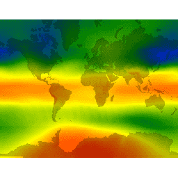
TOMS(Total Ozone Mapping Spectrometer) 데이터는 위성 관측기를 사용해 지난 25년간 전체 오존의 전 세계 및 지역 추세를 모니터링하고 장기간 지속적으로 기록한 것입니다. 이 데이터는 NASA 고다드 우주 비행 센터의 대기 연구소에서 생성됩니다. 버전 8 TOMS 데이터 제품에는 레벨 3 그리드 데이터(1.0 x 1.25도)가 포함됩니다. Aura 위성(2004년 7월~현재)에 탑재된 OMI(Ozone Monitoring Instrument)는 해상도가 더 높습니다(1.0 x 1.0도).
이 데이터는 TOMS/EarthProbe, TOMS/Nimbus-7, TOMS/Meteor-3, OMI/Aura의 병합된 오존 제품과 데이터가 없는 날짜에 대한 USGS 보간 데이터를 나타냅니다.
밴드
픽셀 크기
111,000미터
밴드
| 이름 | 단위 | 최소 | 최대 | 픽셀 크기 | 설명 |
|---|---|---|---|---|---|
ozone |
Dobson | 73* | 983* | 미터 | 전체 열 오존 |
이용약관
이용약관
GES DISC(Goddard Earth Sciences Data and Information Services Center)의 데이터 배포는 NASA의 SMD(Science Mission Directorate)의 지원을 받습니다. NASA 지구과학 데이터 및 정보 정책에 따라 GES DISC 보관 파일의 데이터는 사용자 커뮤니티에 무료로 제공됩니다. 자세한 내용은 GES DISC 데이터 정책 페이지를 참고하세요.
인용
데이터를 사용할 때는 데이터 세트 소스를 적절하게 인용해야 합니다. 공식 참조는 다음과 같은 형식으로 표시합니다. \<저자\\>, 2012년, 2013년 최종 업데이트: \
. NASA/GSFC, Greenbelt, MD, USA, NASA GES DISC(Goddard Earth Sciences Data and Information Services Center). 액세스 데이터 \ </저자\\>\<doi\\> 출처, Parsons 외., 2010년, doi:10.1029/2010EO340001</doi\\>
Earth Engine으로 탐색
코드 편집기(JavaScript)
var dataset = ee.ImageCollection('TOMS/MERGED')
                  .filter(ee.Filter.date('2018-08-01', '2018-08-10'));
var columnOzone = dataset.select('ozone');
var columnOzoneVis = {
  min: 100,
  max: 500,
  palette: ['1621a2', 'cyan', 'green', 'yellow', 'orange', 'red'],
};
Map.setCenter(6.75, 46.53, 2);
Map.addLayer(columnOzone, columnOzoneVis, 'Column Ozone');