The Tropical Rainfall Measuring Mission (TRMM) is a
joint mission between NASA and the Japan Aerospace Exploration
Agency (JAXA) designed to monitor and study tropical rainfall.
The 34B2 product contains a gridded, TRMM-adjusted, merged infrared
precipitation (mm/hr) and RMS precipitation-error estimate, with
a 3-hour temporal resolution and a 0.25 degree spatial resolution.
Satellite observation time minus the time of the granule.
In case of overlapping satellite observations, the two or more
observation times are equal-weighting averaged.
Adler, R.F., G.J. Huffman, A. Chang, R. Ferraro, P. Xie, J. Janowiak,
B. Rudolf, U. Schneider, S. Curtis, D. Bolvin, A. Gruber, J. Susskind,
P. Arkin, E.J. Nelkin, 2003: The Version 2 Global Precipitation
Climatology Project (GPCP) Monthly Precipitation Analysis (1979-Present).
J. Hydrometeor., 4(6), 1147-1167.
Huffman, G.J., 1997: Estimates of Root-Mean-Square Random Error
for Finite Samples of Estimated Precipitation, J. Appl. Meteor.,
1191-1201.
Huffman, G.J., 2012: Algorithm Theoretical Basis Document (ATBD)
Version 3.0 for the NASA Global Precipitation Measurement (GPM)
Integrated Multi-satellitE Retrievals for GPM (I-MERG). GPM Project,
Greenbelt, MD, 29 pp.
Huffman, G.J., R.F. Adler, P. Arkin, A. Chang, R. Ferraro, A.
Gruber, J. Janowiak, A. McNab, B. Rudolph, and U. Schneider, 1997:
The Global Precipitation Climatology Project (GPCP) Combined Precipitation
Dataset, Bul. Amer. Meteor. Soc., 78, 5-20.
Huffman, G.J., R.F. Adler, D.T. Bolvin, G. Gu, E.J. Nelkin, K.P.
Bowman, Y. Hong, E.F. Stocker, D.B. Wolff, 2007: The TRMM Multi-satellite
Precipitation Analysis: Quasi-Global, Multi-Year, Combined-Sensor
Precipitation Estimates at Fine Scale. J. Hydrometeor., 8(1), 38-55.
Huffman, G.J., R.F. Adler, M. Morrissey, D.T. Bolvin, S. Curtis,
R. Joyce, B McGavock, J. Susskind, 2001: Global Precipitation at
One-Degree Daily Resolution from Multi-Satellite Observations. J.
Hydrometeor., 2(1), 36-50.
Huffman, G.J., R.F. Adler, B. Rudolph, U. Schneider, and P. Keehn,
1995: Global Precipitation Estimates Based on a Technique for Combining
Satellite-Based Estimates, Rain Gauge Analysis, and NWP Model Precipitation
Information, J. Clim., 8, 1284-1295.
The Tropical Rainfall Measuring Mission (TRMM) is a joint mission between NASA and the Japan Aerospace Exploration Agency (JAXA) designed to monitor and study tropical rainfall. The 34B2 product contains a gridded, TRMM-adjusted, merged infrared precipitation (mm/hr) and RMS precipitation-error estimate, with a 3-hour temporal resolution and a 0.25 degree …
[null,null,[],[[["\u003cp\u003eThe TRMM 3B42 dataset provides 3-hourly precipitation estimates from 1998 to 2019, covering tropical regions.\u003c/p\u003e\n"],["\u003cp\u003eIt is a joint mission between NASA and JAXA to monitor and study tropical rainfall.\u003c/p\u003e\n"],["\u003cp\u003eThe dataset includes merged microwave/IR precipitation estimates, error estimates, and source flags.\u003c/p\u003e\n"],["\u003cp\u003eData is gridded at a 0.25-degree spatial resolution and is freely available in the public domain.\u003c/p\u003e\n"],["\u003cp\u003eUsers can access and analyze the dataset using Google Earth Engine.\u003c/p\u003e\n"]]],[],null,["# TRMM 3B42: 3-Hourly Precipitation Estimates\n\nDataset Availability\n: 1998-01-01T00:00:00Z--2019-12-31T21:00:00Z\n\nDataset Provider\n:\n\n\n [NASA GES DISC at NASA Goddard Space Flight Center](https://doi.org/10.5067/TRMM/TMPA/3H/7)\n\nCadence\n: 3 Hours\n\nTags\n:\n[3-hourly](/earth-engine/datasets/tags/3-hourly) [climate](/earth-engine/datasets/tags/climate) [geophysical](/earth-engine/datasets/tags/geophysical) [jaxa](/earth-engine/datasets/tags/jaxa) [nasa](/earth-engine/datasets/tags/nasa) [precipitation](/earth-engine/datasets/tags/precipitation) [rainfall](/earth-engine/datasets/tags/rainfall) [trmm](/earth-engine/datasets/tags/trmm) [weather](/earth-engine/datasets/tags/weather) \n\n#### Description\n\nThe Tropical Rainfall Measuring Mission (TRMM) is a\njoint mission between NASA and the Japan Aerospace Exploration\nAgency (JAXA) designed to monitor and study tropical rainfall.\nThe 34B2 product contains a gridded, TRMM-adjusted, merged infrared\nprecipitation (mm/hr) and RMS precipitation-error estimate, with\na 3-hour temporal resolution and a 0.25 degree spatial resolution.\n\nSee the [algorithm description](https://trmm.gsfc.nasa.gov/3b42.html)\nand the [file specification](https://storm.pps.eosdis.nasa.gov/storm/data/docs/filespec.TRMM.V7.3B42.pdf)\nfor details.\n\nDocumentation:\n\n- [PI Documentation](https://docserver.gesdisc.eosdis.nasa.gov/public/project/GPM/3B42_3B43_doc_V7.pdf)\n\n- [File Specification for TRMM Products](https://pps.gsfc.nasa.gov/Documents/filespec.TRMM.V7.pdf)\n\n- [Comparison between TRMM versions 6 and 7](https://pps.gsfc.nasa.gov/Documents/formatChangesV7.pdf)\n\n- [Readme](https://disc2.gesdisc.eosdis.nasa.gov/data/TRMM_L3/TRMM_3B42/doc/README.TRMM_V7.pdf)\n\n- [Details of the TMPA algorithm used in this product](https://pmm.nasa.gov/sites/default/files/imce/3B42_3B43_TMPA_restart.pdf)\n\n- [TRMM Data Gaps](https://web.archive.org/web/20200701000000*/ftp://gpmweb2.pps.eosdis.nasa.gov/tsdis/AB/docs/anomalous.html)\n\n- [Transition from TMPA to IMERG](https://docserver.gesdisc.eosdis.nasa.gov/public/project/GPM/TMPA-to-IMERG_transition.pdf)\n\n### Bands\n\n\n**Pixel Size**\n\n27830 meters\n\n**Bands**\n\n| Name | Units | Min | Max | Pixel Size | Description |\n|--------------------------|-------|-----|-----|------------|--------------------------------------------------------------------------------------------------------------------------------------------------------------------------|---|---|---|---|---|---|---|---|---|---|---|---|---|---|---|---|---|---|---|---|---|---|---|---|---|---|---|---|---|---|---|---|---|---|---|---|---|---|---|---|---|---|---|---|---|---|---|---|---|---|---|---|---|---|---|---|---|---|---|---|---|---|---|---|---|---|---|---|---|---|---|---|---|---|---|---|---|---|---|---|---|---|---|---|---|---|---|---|---|---|---|---|---|---|\n| `precipitation` | mm/hr | 0 | 100 | meters | Merged microwave/IR precipitation estimate |\n| `relativeError` | mm/hr | 0 | 100 | meters | Merged microwave/IR precipitation random error estimate |\n| `satPrecipitationSource` | | | | meters | Flag to show source of data |\n| Bitmask for satPrecipitationSource - Bits 0-5: Source - 0: No observation - 1: AMSU - 2: TMI - 3: AMSR - 4: SSMI - 5: SSMI/S - 6: MHS - 7: TCI - 30: AMSU/MHS average - 31: Conical scanner average - 50: IR ||||||||||||||||||||||||||||||||||||||||||||||||||||||||||||||||||||||||||||||||||||||||||||||||||||\n| `HQprecipitation` | mm/hr | 0 | 100 | meters | Pre-gauge-adjusted microwave precipitation estimate |\n| `IRprecipitation` | mm/hr | 0 | 100 | meters | Pre-gauge-adjusted infrared precipitation estimate |\n| `satObservationTime` | min | -90 | 90 | meters | Satellite observation time minus the time of the granule. In case of overlapping satellite observations, the two or more observation times are equal-weighting averaged. |\n\n### Terms of Use\n\n**Terms of Use**\n\nThis dataset is in the public domain and is available\nwithout restriction on use and distribution. See [NASA's\nEarth Science Data \\& Information Policy](https://www.earthdata.nasa.gov/engage/open-data-services-and-software/data-and-information-policy)\nfor additional information.\n\n### Citations\n\nCitations:\n\n- Adler, R.F., G.J. Huffman, A. Chang, R. Ferraro, P. Xie, J. Janowiak,\n B. Rudolf, U. Schneider, S. Curtis, D. Bolvin, A. Gruber, J. Susskind,\n P. Arkin, E.J. Nelkin, 2003: The Version 2 Global Precipitation\n Climatology Project (GPCP) Monthly Precipitation Analysis (1979-Present).\n J. Hydrometeor., 4(6), 1147-1167.\n- Huffman, G.J., 1997: Estimates of Root-Mean-Square Random Error\n for Finite Samples of Estimated Precipitation, J. Appl. Meteor.,\n 1191-1201.\n- Huffman, G.J., 2012: Algorithm Theoretical Basis Document (ATBD)\n Version 3.0 for the NASA Global Precipitation Measurement (GPM)\n Integrated Multi-satellitE Retrievals for GPM (I-MERG). GPM Project,\n Greenbelt, MD, 29 pp.\n- Huffman, G.J., R.F. Adler, P. Arkin, A. Chang, R. Ferraro, A.\n Gruber, J. Janowiak, A. McNab, B. Rudolph, and U. Schneider, 1997:\n The Global Precipitation Climatology Project (GPCP) Combined Precipitation\n Dataset, Bul. Amer. Meteor. Soc., 78, 5-20.\n- Huffman, G.J., R.F. Adler, D.T. Bolvin, G. Gu, E.J. Nelkin, K.P.\n Bowman, Y. Hong, E.F. Stocker, D.B. Wolff, 2007: The TRMM Multi-satellite\n Precipitation Analysis: Quasi-Global, Multi-Year, Combined-Sensor\n Precipitation Estimates at Fine Scale. J. Hydrometeor., 8(1), 38-55.\n- Huffman, G.J., R.F. Adler, M. Morrissey, D.T. Bolvin, S. Curtis,\n R. Joyce, B McGavock, J. Susskind, 2001: Global Precipitation at\n One-Degree Daily Resolution from Multi-Satellite Observations. J.\n Hydrometeor., 2(1), 36-50.\n- Huffman, G.J., R.F. Adler, B. Rudolph, U. Schneider, and P. Keehn,\n 1995: Global Precipitation Estimates Based on a Technique for Combining\n Satellite-Based Estimates, Rain Gauge Analysis, and NWP Model Precipitation\n Information, J. Clim., 8, 1284-1295.\n\n### 
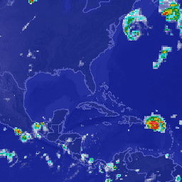
Explore with Earth Engine\n\n| **Important:** Earth Engine is a platform for petabyte-scale scientific analysis and visualization of geospatial datasets, both for public benefit and for business and government users. Earth Engine is free to use for research, education, and nonprofit use. To get started, please [register for Earth Engine access.](https://console.cloud.google.com/earth-engine)\n\n### Code Editor (JavaScript)\n\n```javascript\nvar dataset = ee.ImageCollection('TRMM/3B42')\n .filter(ee.Filter.date('2018-04-01', '2018-04-10'));\nvar precipitation =\n dataset.select(['precipitation', 'HQprecipitation', 'IRprecipitation']);\nvar precipitationVis = {\n min: 0,\n max: 12,\n gamma: 5,\n};\nMap.setCenter(-79.98, 23.32, 4);\nMap.addLayer(precipitation, precipitationVis, 'Precipitation');\n```\n[Open in Code Editor](https://code.earthengine.google.com/?scriptPath=Examples:Datasets/TRMM/TRMM_3B42) \n[TRMM 3B42: 3-Hourly Precipitation Estimates](/earth-engine/datasets/catalog/TRMM_3B42) \nThe Tropical Rainfall Measuring Mission (TRMM) is a joint mission between NASA and the Japan Aerospace Exploration Agency (JAXA) designed to monitor and study tropical rainfall. The 34B2 product contains a gridded, TRMM-adjusted, merged infrared precipitation (mm/hr) and RMS precipitation-error estimate, with a 3-hour temporal resolution and a 0.25 degree ... \nTRMM/3B42, 3-hourly,climate,geophysical,jaxa,nasa,precipitation,rainfall,trmm,weather \n1998-01-01T00:00:00Z/2019-12-31T21:00:00Z \n-50 -180 50 180 \nGoogle Earth Engine \nhttps://developers.google.com/earth-engine/datasets\n\n- [](https://doi.org/https://doi.org/10.5067/TRMM/TMPA/3H/7)\n- [](https://doi.org/https://developers.google.com/earth-engine/datasets/catalog/TRMM_3B42)"]]