Page Summary
-
BigEarthNet is a large-scale archive of 590,326 Sentinel-2 image patches collected over 10 European countries between June 2017 and May 2018.
-
The image patches are atmospherically corrected and annotated with multiple land-cover classes derived from the CORINE Land Cover database.
-
The dataset includes various bands covering different wavelengths from Aerosols to SWIR 2.
-
Image properties include a list of landcover types, the source Sentinel-2 product ID, and tile coordinates.
-
The BigEarthNet Archive is licensed under the Community Data License Agreement - Permissive, Version 1.0.
- Dataset Availability
- 2017-06-01T00:00:00Z–2018-05-31T00:00:00Z
- Dataset Producer
- BigEarthNet
- Tags
Description
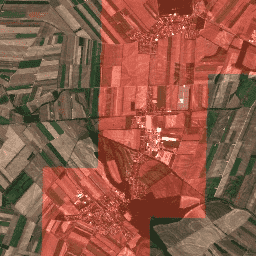
BigEarthNet is a new large-scale Sentinel-2 benchmark archive, consisting of 590,326 Sentinel-2 image patches. To construct BigEarthNet, 125 Sentinel-2 tiles were acquired between June 2017 and May 2018 over the 10 countries (Austria, Belgium, Finland, Ireland, Kosovo, Lithuania, Luxembourg, Portugal, Serbia, Switzerland) of Europe. All the tiles were atmospherically corrected by the Sentinel-2 Level 2A product generation and formatting tool (sen2cor). Then, they were divided into 590,326 non-overlapping image patches. Each image patch was annotated by the multiple land-cover classes (i.e., multi-labels) that were provided from the CORINE Land Cover database of the year 2018 (CLC 2018).
Bands
Bands
Pixel size: varies
| Name | Scale | Pixel Size | Wavelength | Description |
|---|---|---|---|---|
B1 |
0.0001 | 60 meters | 443.9nm (S2A) / 442.3nm (S2B) | Aerosols |
B2 |
0.0001 | 10 meters | 496.6nm (S2A) / 492.1nm (S2B) | Blue |
B3 |
0.0001 | 10 meters | 560nm (S2A) / 559nm (S2B) | Green |
B4 |
0.0001 | 10 meters | 664.5nm (S2A) / 665nm (S2B) | Red |
B5 |
0.0001 | 20 meters | 703.9nm (S2A) / 703.8nm (S2B) | Red Edge 1 |
B6 |
0.0001 | 20 meters | 740.2nm (S2A) / 739.1nm (S2B) | Red Edge 2 |
B7 |
0.0001 | 20 meters | 782.5nm (S2A) / 779.7nm (S2B) | Red Edge 3 |
B8 |
0.0001 | 10 meters | 835.1nm (S2A) / 833nm (S2B) | NIR |
B9 |
0.0001 | 60 meters | 945nm (S2A) / 943.2nm (S2B) | Water vapor |
B10 |
0.0001 | 60 meters | 1373.5nm (S2A) / 1376.9nm (S2B) | Cirrus |
B11 |
0.0001 | 20 meters | 1613.7nm (S2A) / 1610.4nm (S2B) | SWIR 1 |
B12 |
0.0001 | 20 meters | 2202.4nm (S2A) / 2185.7nm (S2B) | SWIR 2 |
B8A |
0.0001 | 20 meters | 864.8nm (S2A) / 864nm (S2B) | Red Edge 4 |
Image Properties
Image Properties
| Name | Type | Description |
|---|---|---|
| labels | STRING_LIST | List of landcover types found in this image |
| source | STRING | Product ID of the corresponding Sentinel-2 1C image |
| tile_x | DOUBLE | X coordinate of tile in source image |
| tile_y | DOUBLE | Y coordinate of tile in source image |
Terms of Use
Terms of Use
The BigEarthNet Archive is licensed under the Community Data License Agreement - Permissive, Version 1.0. For more information, please refer to https://cdla.dev/permissive-1-0.
Citations
G. Sumbul, M. Charfuelan, B. Demir, V. Markl, BigEarthNet: A Large-Scale Benchmark Archive for Remote Sensing Image Understanding, IEEE International Conference on Geoscience and Remote Sensing Symposium, pp. 5901-5904, Yokohama, Japan, 2019.
Explore with Earth Engine
Code Editor (JavaScript)
var geometry = ee.Geometry.Polygon(
    [[
      [16.656886757418057, 48.27086673747943],
      [16.656886757418057, 48.21359065567954],
      [16.733276070162198, 48.21359065567954],
      [16.733276070162198, 48.27086673747943]]]);

var ic = ee.ImageCollection('TUBerlin/BigEarthNet/v1');

var filtered = ic.filterBounds(geometry);

var tiles = filtered.map(function(image) {
  var labels = ee.List(image.get('labels'));

  var urban = labels.indexOf('Discontinuous urban fabric').gte(0);
  var highlight_urban = ee.Image(urban).toInt().multiply(1000);

  return image.addBands(
      {srcImg: image.select(['B4']).add(highlight_urban), overwrite: true});
});

var image = tiles.mosaic().clip(geometry);

var visParams = {bands: ['B4', 'B3', 'B2'], min: 0, max: 3000};

Map.addLayer(image, visParams);
Map.centerObject(image, 13);