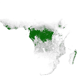
일차 습윤 열대림은 수많은 전 세계 생태계 서비스를 제공하지만 경제적 요인으로 인해 지속적으로 벌채 위협에 직면하고 있습니다. 국토 이용 계획을 촉진하고 경제 발전과 생태계 서비스 유지의 목표를 균형 있게 조정하기 위해 UMD GLAD팀에서 1차 습윤 열대 우림 지도를 만들었습니다. 기본 산림 범위는 전 세계에서 획득하고 무료로 제공되며 일관되게 처리된 Landsat 이미지를 사용하여 2001년의 경우 30미터의 공간 해상도로 매핑되었습니다.
대역
픽셀 크기 30미터
대역
이름
픽셀 크기
설명
Primary_HT_forests
미터
일차 습윤 열대 우림
Primary_HT_forests 클래스 표
값
색상
설명
1
#008000
일차 습윤 열대 우림
이용약관
이용약관
이 데이터는 허가, 라이선스 또는 로열티 지불 없이 누구나 언제 어디서나 사용할 수 있습니다.
권장 인용을 사용한 저작자 표시는 요청됩니다.
인용
인용:
Turubanova S., Potapov P., Tyukavina, A., Hansen M. (2018) 브라질, 콩고 민주공화국, 인도네시아에서 지속적인 원시림 손실이 발생하고 있습니다. Environmental
Research Letters.
https://doi.org/10.1088/1748-9326/aacd1c
1차 습윤 열대 우림은 수많은 글로벌 생태계 서비스를 제공하지만 경제적 동인으로 인한 벌목의 위협이 계속되고 있습니다. 국토 이용 계획을 촉진하고 경제 발전과 생태계 서비스 유지의 목표를 균형 있게 조정하기 위해 UMD GLAD팀에서 기본 습윤 열대 우림 지도를 만들었습니다. …
[null,null,[],[[["\u003cp\u003eThis dataset provides a 30-meter resolution map of primary humid tropical forests for the year 2001.\u003c/p\u003e\n"],["\u003cp\u003eIt was created by the UMD GLAD team using Landsat imagery to support land use planning and ecosystem service maintenance.\u003c/p\u003e\n"],["\u003cp\u003eThe data is freely available for use without restrictions, although attribution is requested.\u003c/p\u003e\n"],["\u003cp\u003eThe dataset highlights the ongoing threat to primary forests from economic drivers, emphasizing the need for balancing development with conservation.\u003c/p\u003e\n"],["\u003cp\u003eUsers can explore and analyze this dataset using Google Earth Engine.\u003c/p\u003e\n"]]],[],null,["# Primary Humid Tropical Forests\n\nDataset Availability\n: 2001-01-01T00:00:00Z--2002-01-01T00:00:00Z\n\nDataset Provider\n:\n\n\n [UMD/GLAD](https://glad.umd.edu/dataset/primary-forest-humid-tropics)\n\nTags\n:\n [forest](/earth-engine/datasets/tags/forest) [forest-biomass](/earth-engine/datasets/tags/forest-biomass) [global](/earth-engine/datasets/tags/global) [landsat-derived](/earth-engine/datasets/tags/landsat-derived) [umd](/earth-engine/datasets/tags/umd) \nglad \n\n#### Description\n\nPrimary humid tropical forests provide numerous global ecosystem services,\nbut are under continuing threat of clearing from economic drivers. To facilitate\nnational land use planning and balancing the goals of economic development and\nmaintenance of ecosystem services, a primary humid tropical forest map was\ncreated by the UMD GLAD team. The primary forest extent was mapped\nfor the year 2001 at a spatial resolution of 30 meters using globally acquired,\nfree-of-charge, and consistently processed Landsat imagery.\n\n### Bands\n\n\n**Pixel Size**\n\n30 meters\n\n**Bands**\n\n| Name | Pixel Size | Description |\n|----------------------|------------|--------------------------------|\n| `Primary_HT_forests` | meters | Primary Humid Tropical Forests |\n\n**Primary_HT_forests Class Table**\n\n| Value | Color | Description |\n|-------|---------|--------------------------------|\n| 1 | #008000 | Primary Humid Tropical Forests |\n\n### Terms of Use\n\n**Terms of Use**\n\nThe data may be used by anyone, anywhere, anytime without permission,\nlicense or royalty payment.\nAttribution using the recommended citation is requested.\n\n### Citations\n\nCitations:\n\n- Turubanova S., Potapov P., Tyukavina, A., and Hansen M. (2018) Ongoing primary forest\n loss in Brazil, Democratic Republic of the Congo, and Indonesia. Environmental\n Research Letters.\n \u003chttps://doi.org/10.1088/1748-9326/aacd1c\u003e\n\n### Explore with Earth Engine\n\n| **Important:** Earth Engine is a platform for petabyte-scale scientific analysis and visualization of geospatial datasets, both for public benefit and for business and government users. Earth Engine is free to use for research, education, and nonprofit use. To get started, please [register for Earth Engine access.](https://console.cloud.google.com/earth-engine)\n\n### Code Editor (JavaScript)\n\n```javascript\nvar dataset = ee.ImageCollection(\n 'UMD/GLAD/PRIMARY_HUMID_TROPICAL_FORESTS/v1').mosaic().selfMask();\n\nvar visualization = {\n bands: ['Primary_HT_forests'],\n min: 1.0,\n max: 1.0,\n palette: ['008000']\n};\n\nMap.setCenter(0.0, 0.0, 2);\n\nMap.addLayer(dataset, visualization, 'Primary HT forests');\n```\n[Open in Code Editor](https://code.earthengine.google.com/?scriptPath=Examples:Datasets/UMD/UMD_GLAD_PRIMARY_HUMID_TROPICAL_FORESTS_v1) \n[Primary Humid Tropical Forests](/earth-engine/datasets/catalog/UMD_GLAD_PRIMARY_HUMID_TROPICAL_FORESTS_v1) \nPrimary humid tropical forests provide numerous global ecosystem services, but are under continuing threat of clearing from economic drivers. To facilitate national land use planning and balancing the goals of economic development and maintenance of ecosystem services, a primary humid tropical forest map was created by the UMD GLAD team. ... \nUMD/GLAD/PRIMARY_HUMID_TROPICAL_FORESTS/v1, forest,forest-biomass,global,landsat-derived,umd \n2001-01-01T00:00:00Z/2002-01-01T00:00:00Z \n-90 -180 90 180 \nGoogle Earth Engine \nhttps://developers.google.com/earth-engine/datasets\n\n- [](https://doi.org/https://glad.umd.edu/dataset/primary-forest-humid-tropics)\n- [](https://doi.org/https://developers.google.com/earth-engine/datasets/catalog/UMD_GLAD_PRIMARY_HUMID_TROPICAL_FORESTS_v1)"]]