- 데이터 세트 사용 가능 기간
- 1986-01-01T00:00:00Z–2020-01-01T00:00:00Z
- 데이터 세트 제공업체
- University of Montana Numerical Terradynamic Simulation Group (NTSG)
- Cadence
- 1년
- 태그
설명
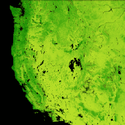
Landsat 순기초 생산량 (NPP) CONUS 데이터 세트는 CONUS의 Landsat 표면 반사율을 사용하여 NPP를 추정합니다. NPP는 호흡으로 인한 손실을 고려한 후 생태계에서 식물에 의해 포착된 탄소의 양입니다. NPP는 Landsat 표면 반사율, gridMET, National Land Cover Database와 함께 MOD17 알고리즘 (MOD17 사용자 가이드 참고)을 사용하여 계산됩니다.
대역
픽셀 크기
30미터
대역
| 이름 | 단위 | 최소 | 최대 | 확장 | 픽셀 크기 | 설명 |
|---|---|---|---|---|---|---|
annualNPP |
kg*C/m^2 | 0 | 65535 | 0.0001 | 미터 | 연간 순 일차 생산량 |
QC |
% | 0 | 255 | 미터 | 갭이 채워진 Landsat 16일 컴포지트의 비율입니다. 누락된 데이터, 높은 클라우드 오염, 잘못된 픽셀로 인해 간격이 발생합니다. 값 255는 갭 채우기 방법의 실패로 인해 데이터가 불완전함을 나타냅니다. |
이용약관
이용약관
이 저작물은 공개 도메인에 속하며 알려진 저작권 제한이 없습니다. 사용자는 이 데이터 세트의 사용으로 생성된 보고서 및 간행물에 사용된 소스를 적절하게 인용하고 데이터가 획득된 날짜를 기록해야 합니다.
인용
인용:
Robinson, N.P., B.W. Allred, W.K. Smith, M.O. Jones, A. Moreno, T.A. Erickson, D.E. Naugle, and S.W. Running. 2018년. Landsat 30m 및 MODIS 250m에서 파생된 미국 본토의 육상 1차 생산량입니다. Remote Sensing in Ecology and Conservation. doi:10.1002/rse2.74
Earth Engine으로 탐색하기
코드 편집기(JavaScript)
var dataset = ee.ImageCollection('UMT/NTSG/v2/LANDSAT/NPP')
                  .filter(ee.Filter.date('2016-01-01', '2016-12-31'));
var npp = dataset.select('annualNPP');
var nppVis = {
  min: 0.0,
  max: 20000.0,
  palette: ['bbe029', '0a9501', '074b03'],
};
Map.setCenter(-98.26, 39.32, 5);
Map.addLayer(npp, nppVis, 'NPP');