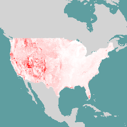
이 데이터 세트는 다음 조건을 충족하는 미국 내 모든 토지의 산불 위험 구성요소를 보여줍니다. 1) 전반적인 지형(즉, 지형의 모든 픽셀에서 측정 가능) 2) 현장 위험을 나타냄(즉, 지형에서 부정적인 영향이 발생하는 위치의 위험)
USDA Forest Service, Rocky Mountain Research Station, Pyrologix LLC에서 생성한 연간 화재 발생 확률 및 화재 강도의 국가 산불 위험 데이터 세트가 커뮤니티의 산불 위험 데이터의 기반을 형성합니다. LANDFIRE 2020(버전 2.2.0)의 식생 및 야생 연료 데이터는 서로 다르지만 관련이 있는 두 가지 지리 공간 화재 시뮬레이션 시스템의 입력으로 사용되었습니다. 연간 화재 발생 확률은 USFS 지리공간 화재 시뮬레이터 (FSim)를 사용하여 비교적 거친 셀 크기인 270미터 (m)로 생성되었습니다. 번 확률 래스터 데이터는 LANDFIRE 연료 및 식생 데이터의 기본 30m 해상도로 업샘플링되어 데이터를 지역 사회의 위험과 위험을 평가하는 데 더 유용한 미세 해상도로 가져왔습니다. 이 업샘플링 프로세스에서 제공자는 모델링된 연소 확률 값을 LANDFIRE 연료 데이터에 연소 불가능으로 표시된 개발 지역으로도 확산시켰습니다.
화재 발생 확률 래스터는 2020년 말의 지형 조건을 나타냅니다. 화재 강도 특성은 화재 시즌에 발생하는 전체 범위의 날씨 관련 특성을 포괄하는 FlamMap 실행을 수행한 다음 이러한 실행을 이러한 날씨 유형이 발생할 가능성에 따라 다양한 결과로 통합하는 프로세스를 사용하여 30m 해상도로 모델링되었습니다. 화재 강도 모델링 전에 2021년과 2022년에 발생한 연료 교란을 반영하도록 LANDFIRE 2020 데이터가 업데이트되었습니다. 따라서 화재 강도 데이터 세트는 2022년 말의 지형 조건을 나타냅니다.
대역
픽셀 크기 30미터
대역
이름
단위
최소
최대
픽셀 크기
설명
BP
0
0.14
미터
연간 화재 발생 확률입니다.
CFL
피트
0
861.7
미터
조건부 화염 길이: 화재가 발생할 경우 최대 확산 방향으로 연소되는 화재의 평균 화염 길이입니다. 산불 강도의 평균 측정값입니다.
CRPS
0
100
미터
잠재적 구조물에 대한 조건부 위험: 화재가 발생하고 해당 위치에 주택이 있는 경우 특정 위치의 주택에 대한 화재의 잠재적 결과입니다.
Exposure
0
1
미터
주택이 산불에 얼마나 노출되는지를 측정한 값입니다. 값 1은 '직접' 노출입니다. 0과 1 사이의 값은 '간접' 노출을 나타내며, 값이 클수록 직접 노출된 영역에 더 가까이 있음을 나타냅니다.
FLEP4
0
1
미터
화염 길이 초과 확률 - 4피트: 화재 발생 시 픽셀의 화염 길이가 4피트를 초과할 조건부 확률입니다. 중간에서 높은 산불 강도의 가능성을 나타냅니다.
FLEP8
0
1
미터
농장 길이 초과 확률 - 8피트: 화재 발생 시 픽셀의 화염 길이가 8피트를 초과할 조건부 확률입니다. 산불 강도가 높을 가능성을 나타냅니다.
RPS
0
13.2
미터
잠재적 구조물에 대한 위험: 해당 위치에 집이 있는 경우 집의 상대적 위험입니다.
WHP
0
99.853
미터
산불 위험 가능성 지수입니다.
이용약관
이용약관
데이터 간행물은 재배포, 인용, 알림, 배포 책임과 같은 사용 조건을 설명하는 데이터 사용 계약에 따라 일반에 무료로 제공됩니다. 이 저장소에서 데이터를 획득하는 모든 사용자는 오픈 액세스 - 데이터 사용 계약에 암묵적으로 동의한 것으로 간주됩니다.
공식적으로 보관 파일로 게시된 데이터 세트는 크리에이티브 커먼즈 CC-BY 라이선스 구조에 따라 출시됩니다. 이를 통해 데이터 출처를 인용하여 사용을 문서화하고 저자의 지적 작업을 인정해야 한다는 기대치를 유지하면서 광범위하게 사용하고 재사용할 수 있습니다.
인용
인용:
Scott, Joe H.; Dillon, Gregory K.; Jaffe, Melissa R.; Vogler, Kevin C.;
Olszewski, Julia H.; Callahan, Michael N.; Karau, Eva C.; Lazarz,
Mitchell T.; Short, Karen C.; Riley, Karin L.; Finney, Mark A.; Grenfell,
Isaac C. 2024년 커뮤니티의 산불 위험: 미국의 전반적인 산불 위험 구성요소의 공간 데이터 세트입니다. 2판.
Fort Collins, CO: Forest Service Research Data Archive.
doi:10.2737/RDS-2020-0016-2
[null,null,[],[[["\u003cp\u003eThis dataset, provided by the USDA Forest Service Research Data Archive, offers a comprehensive view of wildfire risk components across all lands in the United States, spanning from 2020-12-31 to 2022-12-31.\u003c/p\u003e\n"],["\u003cp\u003eThe data includes annual burn probability and fire intensity metrics, with burn probability data upsampled to a 30m resolution and fire intensity data reflecting landscape conditions as of the end of 2022.\u003c/p\u003e\n"],["\u003cp\u003eThe dataset includes multiple bands, including \u003ccode\u003eBP\u003c/code\u003e (Annual Burn Probability), \u003ccode\u003eCFL\u003c/code\u003e (Conditional Flame Length), \u003ccode\u003eCRPS\u003c/code\u003e (Conditional Risk to Potential Structures), and \u003ccode\u003eWHP\u003c/code\u003e (Wildfire Hazard Potential index), each offering specific insights into wildfire risk.\u003c/p\u003e\n"],["\u003cp\u003eThis data can be accessed via an Earth Engine snippet, and is freely available to the public under a data use agreement, which includes attribution and citation guidelines as a condition of use.\u003c/p\u003e\n"],["\u003cp\u003eThe data is used to depict risk that is landscape-wide and represents in situ risk, with more information on its generation and usage available through the provided USDA website and the data publication's DOI.\u003c/p\u003e\n"]]],[],null,["# Wildfire Risk to Communities v0\n\nDataset Availability\n: 2020-12-31T00:00:00Z--2022-12-31T00:00:00Z\n\nDataset Provider\n:\n\n\n [USDA Forest Service Research Data Archive](https://www.fs.usda.gov/rds/archive/catalog/RDS-2020-0016-2)\n\nTags\n:\n[burn](/earth-engine/datasets/tags/burn) [fire](/earth-engine/datasets/tags/fire) [usda](/earth-engine/datasets/tags/usda) [wildfire](/earth-engine/datasets/tags/wildfire) \n\n#### Description\n\nThis dataset depicts components of wildfire risk for all lands in the United\nStates that: 1) are landscape-wide (i.e., measurable at every pixel across\nthe landscape); and 2) represent in situ risk - risk at the location where\nthe adverse effects take place on the landscape.\n\nNational wildfire hazard datasets of annual burn probability and fire\nintensity, generated by the USDA Forest Service, Rocky Mountain Researc\nStation and Pyrologix LLC, form the foundation of the Wildfire Risk to\nCommunities data. Vegetation and wildland fuels data from LANDFIRE 2020\n(version 2.2.0) were used as input to two different but related geospatial\nfire simulation systems. Annual burn probability was produced with the USFS\ngeospatial fire simulator (FSim) at a relatively coarse cell size of 270\nmeters (m). The burn probability raster data was upsampled to the native\n30 m resolution of the LANDFIRE fuel and vegetation data, to bring the data\ndown to a finer resolution more useful for assessing hazard and risk to\ncommunities. In this upsampling process, the provider also spread values of\nmodeled burn probability into developed areas represented in LANDFIRE fuels\ndata as non-burnable.\n\nBurn probability rasters represent landscape\nconditions as of the end of 2020. Fire intensity characteristics were\nmodeled at 30 m resolution using a process that performs a comprehensive\nset of FlamMap runs spanning the full range of weather-related\ncharacteristics that occur during a fire season and then integrates those\nruns into a variety of results based on the likelihood of those weather\ntypes occurring. Before the fire intensity modeling, the LANDFIRE 2020 data\nwere updated to reflect fuels disturbances occurring in 2021 and 2022. As\nsuch, the fire intensity datasets represent landscape conditions as of the\nend of 2022.\n\n### Bands\n\n\n**Pixel Size**\n\n30 meters\n\n**Bands**\n\n| Name | Units | Min | Max | Pixel Size | Description |\n|------------|-------|-----|--------|------------|---------------------------------------------------------------------------------------------------------------------------------------------------------------------------------------------------------------------------------|\n| `BP` | | 0 | 0.14 | meters | Annual Burn Probability. |\n| `CFL` | ft | 0 | 861.7 | meters | Conditional Flame Length; mean flame length for fire burning in direction of maximum spread if a fire were to occur. Avg. measure of wildfire intensity. |\n| `CRPS` | | 0 | 100 | meters | Conditional Risk to Potential Structures; potential consequences of fire to a home at a given location, if a fire occurs there and if a home were located there. |\n| `Exposure` | | 0 | 1 | meters | Measure of how exposed a housing unit would be to wildfire. A value of 1 is \"direct\" exposure. Values between 0 and 1 represent \"indirect\" exposure, with higher values representing closer proximity to directly exposed areas |\n| `FLEP4` | | 0 | 1 | meters | Flame Length Exceedance Probability - 4 ft; conditional probability that flame length at a pixel will exceed 4 feet if a fire occurs; indicates the potential for moderate to high wildfire intensity. |\n| `FLEP8` | | 0 | 1 | meters | Farm Length Exceedance Probability - 8 ft; conditional probability that flame length at a pixel will exceed 8 feet if a fire occurs; indicates the potential for high wildfire intensity. |\n| `RPS` | | 0 | 13.2 | meters | Risk to Potential Structures; relative risk to a house if one existed at that location. |\n| `WHP` | | 0 | 99.853 | meters | Wildfire Hazard Potential index. |\n\n### Terms of Use\n\n**Terms of Use**\n\n[CC-BY-4.0](https://spdx.org/licenses/CC-BY-4.0.html)\n\n### Citations\n\nCitations:\n\n- Scott, Joe H.; Dillon, Gregory K.; Jaffe, Melissa R.; Vogler, Kevin C.;\n Olszewski, Julia H.; Callahan, Michael N.; Karau, Eva C.; Lazarz,\n Mitchell T.; Short, Karen C.; Riley, Karin L.; Finney, Mark A.; Grenfell,\n Isaac C. 2024. Wildfire Risk to Communities: Spatial datasets of\n landscape-wide wildfire risk components for the United States. 2nd Edition.\n Fort Collins, CO: Forest Service Research Data Archive.\n [doi:10.2737/RDS-2020-0016-2](https://doi.org/10.2737/RDS-2020-0016-2)\n\n### DOIs\n\n- \u003chttps://doi.org/10.2737/RDS-2020-0016-2\u003e\n\n### Explore with Earth Engine\n\n| **Important:** Earth Engine is a platform for petabyte-scale scientific analysis and visualization of geospatial datasets, both for public benefit and for business and government users. Earth Engine is free to use for research, education, and nonprofit use. To get started, please [register for Earth Engine access.](https://console.cloud.google.com/earth-engine)\n\n### Code Editor (JavaScript)\n\n```javascript\nvar dataset = ee.ImageCollection('USDA/WRC/v0').mosaic()\nvar cfl = dataset.select('CFL');\nvar vis = {min: 0, max: 30, palette: ['white', 'red']}\nMap.addLayer(cfl, vis, 'Conditional Flame Length');\nMap.setCenter(-101, 39, 4)\n```\n[Open in Code Editor](https://code.earthengine.google.com/?scriptPath=Examples:Datasets/USDA/USDA_WRC_v0) \n[Wildfire Risk to Communities v0](/earth-engine/datasets/catalog/USDA_WRC_v0) \nThis dataset depicts components of wildfire risk for all lands in the United States that: 1) are landscape-wide (i.e., measurable at every pixel across the landscape); and 2) represent in situ risk - risk at the location where the adverse effects take place on the landscape. National wildfire hazard datasets ... \nUSDA/WRC/v0, burn,fire,usda,wildfire \n2020-12-31T00:00:00Z/2022-12-31T00:00:00Z \n-67.933 -180 63.904 18.854 \nGoogle Earth Engine \nhttps://developers.google.com/earth-engine/datasets\n\n- [https://doi.org/10.2737/RDS-2020-0016-2](https://doi.org/https://www.fs.usda.gov/rds/archive/catalog/RDS-2020-0016-2)\n- [https://doi.org/10.2737/RDS-2020-0016-2](https://doi.org/https://developers.google.com/earth-engine/datasets/catalog/USDA_WRC_v0)"]]