- Dataset-Verfügbarkeit
- 2015-01-01T00:00:00Z–2006-01-01T00:00:00Z
- Dataset-Anbieter
- United States Geological Survey
- Tags
Beschreibung
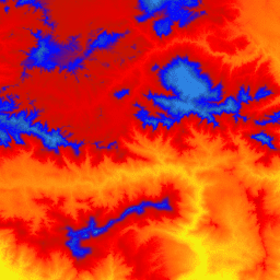
Dies ist eine gekachelte Sammlung von Bildern mit einer Pixelgröße von 1 m aus dem 3D Elevation Program (3DEP). Die 3DEP-Datenbestände dienen als Höhenschicht der National Map und liefern grundlegende Höheninformationen für geowissenschaftliche Studien und Kartierungsanwendungen in den USA.
Die Höhen in diesem DEM stellen die topografische Oberfläche der Erde dar. DEMs mit einer Standard-Pixelgröße von 1 m der USGS werden ausschließlich aus hochauflösenden Lidar-Quelldaten (Light Detection and Ranging) von Bildern mit einer Pixelgröße von 1 m oder höherer Auflösung erstellt. DEM-Oberflächen mit einer Pixelgröße von 1 m sind innerhalb von Erfassungsprojekten nahtlos, aber nicht unbedingt projektübergreifend. Der für Kacheln des DEM mit einer Pixelgröße von 1 m in den angrenzenden Vereinigten Staaten (CONUS) verwendete Raumbezug ist Universal Transverse Mercator (UTM) in Metern und in Übereinstimmung mit dem North American Datum von 1983 (NAD83). Alle Werte für die Höhe des Erdbodens sind in Metern angegeben und beziehen sich auf das North American Vertical Datum of 1988 (NAVD88). Jede Kachel wird in der UTM-Zone verteilt, in der sie sich befindet. Wenn eine Kachel zwei UTM-Zonen durchläuft, wird sie in beiden Zonen bereitgestellt. In diesem und anderen Fällen von Bildüberlappungen können die Höhenwerte in verschiedenen Bildern, die denselben Bereich abdecken, leicht unterschiedlich sein.
Das DEM mit einer Pixelgröße von 1 m ist das Standard-DEM mit der höchsten Auflösung, das in der 3DEP-Produktreihe angeboten wird. Das 3DEP-Dataset mit einer Auflösung von 10 m ist unter USGS_3DEP_10m verfügbar.
Bänder
Bänder
| Name | Einheiten | Pixelgröße | Beschreibung |
|---|---|---|---|
elevation |
m | 1 Meter | Höhe (NAVD88) |
Nutzungsbedingungen
Nutzungsbedingungen
Die meisten Informationen des United States Geological Survey (USGS) sind öffentlich und dürfen ohne Einschränkung verwendet werden. Weitere Informationen zum Angeben oder Erwähnen der USGS als Informationsquelle
Zitate
U.S. Geological Survey, 3D Elevation Program, digitales Höhenmodell mit einer Auflösung von 1 Meter.
Earth Engine nutzen
Code-Editor (JavaScript)
var dataset = ee.ImageCollection('USGS/3DEP/1m');
var visualization = {
  min: 0,
  max: 3000,
  palette: [
    '3ae237', 'b5e22e', 'd6e21f', 'fff705', 'ffd611', 'ffb613', 'ff8b13',
    'ff6e08', 'ff500d', 'ff0000', 'de0101', 'c21301', '0602ff', '235cb1',
    '307ef3', '269db1', '30c8e2', '32d3ef', '3be285', '3ff38f', '86e26f'
  ],
};
Map.setCenter(-119.0, 34.6, 10);
Map.addLayer(dataset, visualization, 'elevation');