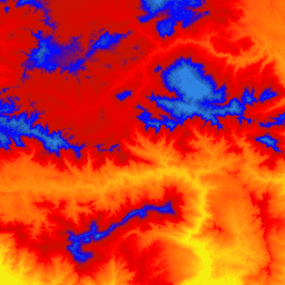
3D 고도 프로그램 (3DEP)의 1m 픽셀 크기 이미지가 타일로 구성된 컬렉션입니다. 3DEP 데이터 보유량은 National Map의 고도 레이어 역할을 하며 미국에서 지구 과학 연구 및 매핑 애플리케이션을 위한 기본적인 고도 정보를 제공합니다.
이 DEM의 고도는 지형의 노출된 지표면을 나타냅니다.
USGS 표준 1m 픽셀 크기 DEM은 1m 픽셀 크기 또는 그 이상의 해상도를 가진 이미지의 고해상도 광선 감지 및 거리 측정 (lidar) 소스 데이터에서만 생성됩니다. 1m 픽셀 크기 DEM 표면은 컬렉션 프로젝트 내에서는 원활하지만 프로젝트 간에는 원활하지 않을 수 있습니다.
미국 본토 (CONUS) 내 1m 픽셀 크기 DEM 타일에 사용되는 공간 참조는 미터 단위의 범용 횡단 메르카토르 (UTM)이며 1983년 북미 기준점(NAD83)을 준수합니다. 모든 지표면 고도 값은 미터 단위이며 1988년 북미 수직 기준점 (NAVD88)을 참조합니다. 각 타일은 해당 타일이 있는 UTM 영역에 배포됩니다. 타일이 두 개의 UTM 영역을 교차하는 경우 두 영역 모두에 제공됩니다.
이 경우와 이미지 중복의 다른 경우에 동일한 영역을 포함하는 여러 이미지의 고도 값이 약간 다를 수 있습니다.
1m 픽셀 크기 DEM은 3DEP 제품군에서 제공되는 최고 해상도 표준 DEM입니다. 10m 3DEP 데이터세트는 USGS_3DEP_10m에서 확인할 수 있습니다.
대역
대역
이름
단위
픽셀 크기
설명
elevation
m
1미터
고도 (NAVD88)
이용약관
이용약관
대부분의 미국 지질조사국 (USGS) 정보는 퍼블릭 도메인에 있으며 제한 없이 사용할 수 있습니다. 정보 소스로 USGS를 인용 또는 표시에 관한 추가 정보를 확인할 수 있습니다.
[null,null,[],[[["\u003cp\u003eThe USGS 3DEP 1m dataset provides elevation data for the United States with 1-meter resolution.\u003c/p\u003e\n"],["\u003cp\u003eThis dataset is primarily derived from high-resolution LiDAR data and represents bare-earth topography.\u003c/p\u003e\n"],["\u003cp\u003eElevation values are referenced to NAVD88 and the dataset is available as a tiled image collection in Earth Engine.\u003c/p\u003e\n"],["\u003cp\u003eWhile seamless within projects, tiles may have slight elevation differences where they overlap.\u003c/p\u003e\n"],["\u003cp\u003eThe dataset is freely available for research, education, and non-profit use through the USGS and Earth Engine.\u003c/p\u003e\n"]]],["The USGS 3DEP 1m dataset provides 1-meter resolution elevation data for the United States, from 2006 to 2015. Data is sourced from high-resolution lidar and is accessible via the Earth Engine using the `ee.ImageCollection(\"USGS/3DEP/1m\")` snippet. The dataset's elevations represent bare-earth surfaces referenced to the NAVD88 vertical datum, and the dataset is seamless within collection projects. Tiles use UTM projection and are available in overlapping zones. Public domain use is permitted with USGS acknowledgment.\n"],null,["# USGS 3DEP 1m National Map\n\nDataset Availability\n: 2015-01-01T00:00:00Z--2006-01-01T00:00:00Z\n\nDataset Provider\n:\n\n\n [United States Geological Survey](https://www.sciencebase.gov/catalog/item/543e6b86e4b0fd76af69cf4c)\n\nTags\n:\n[3dep](/earth-engine/datasets/tags/3dep) [dem](/earth-engine/datasets/tags/dem) [elevation](/earth-engine/datasets/tags/elevation) [elevation-topography](/earth-engine/datasets/tags/elevation-topography) [geophysical](/earth-engine/datasets/tags/geophysical) [topography](/earth-engine/datasets/tags/topography) [usgs](/earth-engine/datasets/tags/usgs) \n\n#### Description\n\nThis is a tiled collection of images with 1m pixel size from the 3D\nElevation Program (3DEP). The 3DEP data holdings serve as the elevation\nlayer of The National Map and provide foundational elevation information for\nearth science studies and mapping applications in the United States.\n\nThe elevations in this DEM represent the topographic bare-earth surface.\nUSGS standard 1m pixel size DEMs are produced exclusively from high\nresolution light detection and ranging (lidar) source data of images with 1m\npixel size or higher resolution. 1m pixel size DEM surfaces are seamless\nwithin collection projects but not necessarily seamless across projects.\nThe spatial reference used for tiles of the 1m pixel size DEM within the\nconterminous United States (CONUS) is Universal Transverse Mercator (UTM) in\nunits of meters and in conformance with the North American Datum of 1983\n(NAD83). All bare earth elevation values are in meters and are referenced to\nthe North American Vertical Datum of 1988 (NAVD88). Each tile is distributed\nin the UTM Zone in which it lies. If a tile crosses two UTM zones, it is\ndelivered in both zones.\nIn this and other cases of image overlaps, elevation values might be\nslightly different in different images covering the same area.\n\nThe 1m pixel size DEM is the highest resolution standard DEM offered in the\n3DEP product suite. The 10m 3DEP dataset is available at\n[USGS_3DEP_10m](/earth-engine/datasets/catalog/USGS_3DEP_10m).\n\n### Bands\n\n**Bands**\n\n| Name | Units | Pixel Size | Description |\n|-------------|-------|------------|--------------------|\n| `elevation` | m | 1 meters | Elevation (NAVD88) |\n\n### Terms of Use\n\n**Terms of Use**\n\nMost U.S. Geological Survey (USGS) information resides\nin the public domain and may be used without restriction. Additional\ninformation on [Acknowledging or Crediting USGS as Information\nSource](https://www.usgs.gov/information-policies-and-instructions/crediting-usgs)\nis available.\n\n### Citations\n\nCitations:\n\n- U.S. Geological Survey, 3D Elevation Program 1-Meter Resolution Digital\n Elevation Model.\n\n### Explore with Earth Engine\n\n| **Important:** Earth Engine is a platform for petabyte-scale scientific analysis and visualization of geospatial datasets, both for public benefit and for business and government users. Earth Engine is free to use for research, education, and nonprofit use. To get started, please [register for Earth Engine access.](https://console.cloud.google.com/earth-engine)\n\n### Code Editor (JavaScript)\n\n```javascript\nvar dataset = ee.ImageCollection('USGS/3DEP/1m');\nvar visualization = {\n min: 0,\n max: 3000,\n palette: [\n '3ae237', 'b5e22e', 'd6e21f', 'fff705', 'ffd611', 'ffb613', 'ff8b13',\n 'ff6e08', 'ff500d', 'ff0000', 'de0101', 'c21301', '0602ff', '235cb1',\n '307ef3', '269db1', '30c8e2', '32d3ef', '3be285', '3ff38f', '86e26f'\n ],\n};\nMap.setCenter(-119.0, 34.6, 10);\nMap.addLayer(dataset, visualization, 'elevation');\n```\n[Open in Code Editor](https://code.earthengine.google.com/?scriptPath=Examples:Datasets/USGS/USGS_3DEP_1m) \n[USGS 3DEP 1m National Map](/earth-engine/datasets/catalog/USGS_3DEP_1m) \nThis is a tiled collection of images with 1m pixel size from the 3D Elevation Program (3DEP). The 3DEP data holdings serve as the elevation layer of The National Map and provide foundational elevation information for earth science studies and mapping applications in the United States. The elevations in this ... \nUSGS/3DEP/1m, 3dep,dem,elevation,elevation-topography,geophysical,topography,usgs \n2015-01-01T00:00:00Z/2006-01-01T00:00:00Z \n-16.6 -171 76.9 164 \nGoogle Earth Engine \nhttps://developers.google.com/earth-engine/datasets\n\n- [](https://doi.org/https://www.sciencebase.gov/catalog/item/543e6b86e4b0fd76af69cf4c)\n- [](https://doi.org/https://developers.google.com/earth-engine/datasets/catalog/USGS_3DEP_1m)"]]