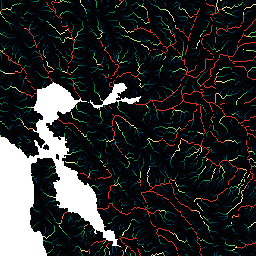
HydroSHEDS는 일관된 형식으로 지역 및 전역 규모 애플리케이션에 수문학 정보를 제공하는 매핑 제품입니다. 하천 네트워크, 유역 경계, 배수 방향, 흐름 누적 등 다양한 규모의 지리 참조 데이터 세트 (벡터 및 래스터)를 제공합니다. HydroSHEDS는 2000년에 NASA의 셔틀 레이더 지형 임무 (SRTM)에서 획득한 고도 데이터를 기반으로 합니다.
이 흐름 누적 데이터 세트는 각 셀로 배수되는 상류 영역의 양 (셀 수)을 정의합니다. 배수 방향 레이어는 타겟 셀로 흐르는 셀을 정의하는 데 사용됩니다. 누적된 셀 수는 기본적으로 업스트림 집수 지역의 측정값입니다. 하지만 HydroSHEDS 데이터 세트의 셀 크기는 위도에 따라 달라지므로 셀 누적 값을 제곱킬로미터 단위의 유역 면적으로 직접 변환할 수는 없습니다. 값은 지형이 높은 곳 (강의 수원)의 1부터 큰 강의 하구에 있는 매우 큰 수 (수백만 개의 셀)까지 다양합니다.
이 데이터 세트는 15초 해상도입니다. 15초에서 사용할 수 있는 데이터 세트는 수문학적 조건 DEM, 배수(흐름) 방향, 흐름 누적입니다.
기본 SRTM 고도 데이터를 사용할 수 없어 더 조잡한 해상도의 DEM (USGS에서 제공한 HYDRO1k)이 사용되었기 때문에 북위 60도 이상의 지역에서는 HydroSHEDS 데이터의 품질이 크게 낮습니다.
HydroSHEDS는 세계자연기금 (WWF) 보존 과학 프로그램이 미국 지질조사국, 국제 열대 농업 센터, 네이처 컨서번시, 독일 카셀 대학교 환경 시스템 연구 센터와 협력하여 개발했습니다.
대역
픽셀 크기 463.83미터
대역
이름
최소
최대
픽셀 크기
설명
b1
1*
2.78651e+07*
미터
흐름 누적
* 예상 최솟값 또는 최댓값
이용약관
이용약관
HydroSHEDS 데이터는 비상업적 및 상업적 용도로 무료로 사용할 수 있습니다. 자세한 내용은 라이선스 계약을 참고하세요.
인용
인용:
Lehner, B., Verdin, K., Jarvis, A. (2008): New global hydrography
derived from spaceborne elevation data. Eos, Transactions, AGU,
89(10): 93-94.
HydroSHEDS는 지역 및 전 세계 규모 애플리케이션에 수문학 정보를 일관된 형식으로 제공하는 매핑 제품입니다. 하천 네트워크, 유역 경계, 배수 방향, 흐름 누적 등 다양한 규모의 지리 참조 데이터 세트 (벡터 및 래스터)를 제공합니다. HydroSHEDS는 2000년에 획득한 고도 데이터를 기반으로 합니다.
[null,null,[],[[["\u003cp\u003eHydroSHEDS provides hydrographic information like river networks, watershed boundaries, and flow accumulation, globally at various scales.\u003c/p\u003e\n"],["\u003cp\u003eThis dataset, at 15 arc-second resolution, specifically represents the amount of upstream area draining into each cell, derived from SRTM elevation data.\u003c/p\u003e\n"],["\u003cp\u003eData quality is lower above 60 degrees northern latitude due to reliance on coarser-resolution DEM.\u003c/p\u003e\n"],["\u003cp\u003eHydroSHEDS data is free for both non-commercial and commercial use under the provided license agreement.\u003c/p\u003e\n"],["\u003cp\u003eDeveloped by WWF in partnership with USGS, CIAT, TNC, and the University of Kassel.\u003c/p\u003e\n"]]],[],null,["# WWF HydroSHEDS Flow Accumulation, 15 Arc-Seconds\n\nDataset Availability\n: 2000-02-11T00:00:00Z--2000-02-22T00:00:00Z\n\nDataset Provider\n:\n\n\n [WWF](https://www.hydrosheds.org/)\n\nTags\n:\n[accumulation](/earth-engine/datasets/tags/accumulation) [drainage](/earth-engine/datasets/tags/drainage) [flow](/earth-engine/datasets/tags/flow) [geophysical](/earth-engine/datasets/tags/geophysical) [hydrography](/earth-engine/datasets/tags/hydrography) [hydrology](/earth-engine/datasets/tags/hydrology) [hydrosheds](/earth-engine/datasets/tags/hydrosheds) [srtm](/earth-engine/datasets/tags/srtm) [surface-ground-water](/earth-engine/datasets/tags/surface-ground-water) [water](/earth-engine/datasets/tags/water) [wwf](/earth-engine/datasets/tags/wwf) \n\n#### Description\n\nHydroSHEDS is a mapping product that provides hydrographic\ninformation for regional and global-scale applications in a consistent\nformat. It offers a suite of geo-referenced datasets (vector and\nraster) at various scales, including river networks, watershed\nboundaries, drainage directions, and flow accumulations. HydroSHEDS\nis based on elevation data obtained in 2000 by NASA's Shuttle Radar\nTopography Mission (SRTM).\n\nThis flow accumulation dataset defines the amount of\nupstream area (in number of cells) draining into each cell. The\ndrainage direction layer is used to define which cells flow into\nthe target cell. The number of accumulated cells is essentially\na measure of the upstream catchment area. However, since the\ncell size of the HydroSHEDS data set depends on latitude, the\ncell accumulation value cannot directly be translated into drainage\nareas in square kilometers. Values range from 1 at topographic\nhighs (river sources) to very large numbers (on the order of\nmillions of cells) at the mouths of large rivers.\n\nThis dataset is at 15 arc-second resolution. The datasets available\nat 15 arc-seconds are the Hydrologically Conditioned DEM, Drainage\n(Flow) Direction, and Flow Accumulation.\n\nNote that the quality of the HydroSHEDS data is significantly lower for regions above\n60 degrees northern latitude as there is no underlying SRTM elevation data available\nand thus a coarser-resolution DEM was (HYDRO1k provided by USGS).\n\nHydroSHEDS was developed by the World Wildlife Fund (WWF)\nConservation Science Program in partnership with the U.S. Geological\nSurvey, the International Centre for Tropical Agriculture, The\nNature Conservancy, and the Center for Environmental Systems Research\nof the University of Kassel, Germany.\n\n### Bands\n\n\n**Pixel Size**\n\n463.83 meters\n\n**Bands**\n\n| Name | Min | Max | Pixel Size | Description |\n|------|-----|---------------|------------|-------------------|\n| `b1` | 1\\* | 2.78651e+07\\* | meters | Flow accumulation |\n\n\\* estimated min or max value\n\n### Terms of Use\n\n**Terms of Use**\n\nHydroSHEDS data are free for non-commercial and commercial\nuse. For more information, please refer to the [License Agreement](https://www.hydrosheds.org/page/license).\n\n### Citations\n\nCitations:\n\n- Lehner, B., Verdin, K., Jarvis, A. (2008): New global hydrography\n derived from spaceborne elevation data. Eos, Transactions, AGU,\n 89(10): 93-94.\n\n### Explore with Earth Engine\n\n| **Important:** Earth Engine is a platform for petabyte-scale scientific analysis and visualization of geospatial datasets, both for public benefit and for business and government users. Earth Engine is free to use for research, education, and nonprofit use. To get started, please [register for Earth Engine access.](https://console.cloud.google.com/earth-engine)\n\n### Code Editor (JavaScript)\n\n```javascript\nvar dataset = ee.Image('WWF/HydroSHEDS/15ACC');\nvar flowAccumulation = dataset.select('b1');\nvar flowAccumulationVis = {\n min: 0.0,\n max: 500.0,\n palette: [\n '000000', '023858', '006837', '1a9850', '66bd63', 'a6d96a', 'd9ef8b',\n 'ffffbf', 'fee08b', 'fdae61', 'f46d43', 'd73027'\n ],\n};\nMap.setCenter(-121.652, 38.022, 8);\nMap.addLayer(flowAccumulation, flowAccumulationVis, 'Flow Accumulation');\n```\n[Open in Code Editor](https://code.earthengine.google.com/?scriptPath=Examples:Datasets/WWF/WWF_HydroSHEDS_15ACC) \n[WWF HydroSHEDS Flow Accumulation, 15 Arc-Seconds](/earth-engine/datasets/catalog/WWF_HydroSHEDS_15ACC) \nHydroSHEDS is a mapping product that provides hydrographic information for regional and global-scale applications in a consistent format. It offers a suite of geo-referenced datasets (vector and raster) at various scales, including river networks, watershed boundaries, drainage directions, and flow accumulations. HydroSHEDS is based on elevation data obtained in 2000 ... \nWWF/HydroSHEDS/15ACC, accumulation,drainage,flow,geophysical,hydrography,hydrology,hydrosheds,srtm,surface-ground-water,water,wwf \n2000-02-11T00:00:00Z/2000-02-22T00:00:00Z \n-67.3 -180 62 180 \nGoogle Earth Engine \nhttps://developers.google.com/earth-engine/datasets\n\n- [](https://doi.org/https://www.hydrosheds.org/)\n- [](https://doi.org/https://developers.google.com/earth-engine/datasets/catalog/WWF_HydroSHEDS_15ACC)"]]