Бесшовная карта страны USGS 3DEP 10 м (1/3 угловой секунды) 
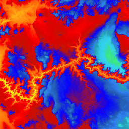
Это набор данных 3DEP DEM для США с полным покрытием 48 сопредельных штатов, Гавайев и других территорий США. Покрытие Аляски уже частично доступно и расширяется до охвата всего штата в рамках Инициативы по картографированию Аляски. Расстояние между точками на местности… 3dep dem altitude altitude-topography геофизическая топография Национальная карта USGS 3DEP 1m 
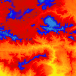
Это мозаичная коллекция изображений размером 1 м из Программы трёхмерной съемки рельефа (3DEP). Данные 3DEP служат слоем рельефа Национальной карты и предоставляют основополагающую информацию о рельефе для геологических исследований и картографических приложений в Соединённых Штатах… 3dep dem altitude altitude-topography геофизическая топография Пространственные метаданные национальной карты USGS 3DEP, 1/3 угловой секунды (10 м) 
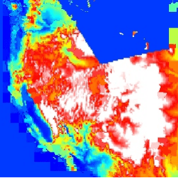
Это таблица с метаданными для ресурса 3DEP 10m DEM. Единица работы Extent Spatial Metadata (WESM) содержит текущую доступность лидарных данных и основную информацию о лидарных проектах, включая уровень качества лидарных данных, даты получения данных и ссылки на метаданные уровня проекта. Подробнее… 3DEP таблица высот и топографии USGS
Datasets tagged 3dep in Earth Engine
[null,null,[],[[["\u003cp\u003eThe USGS 3DEP provides seamless 10m resolution elevation data for the conterminous U.S., Hawaii, and U.S. territories, with expanding coverage for Alaska.\u003c/p\u003e\n"],["\u003cp\u003eMetadata for the 3DEP 10m DEM is available, including lidar data availability, quality level, acquisition dates, and project-level metadata links.\u003c/p\u003e\n"],["\u003cp\u003eThe USGS 3DEP also offers a tiled collection of 1m resolution elevation images, serving as the elevation layer of The National Map for various applications.\u003c/p\u003e\n"]]],["The USGS 3DEP dataset offers seamless DEM data for the US, including the 48 contiguous states, Hawaii, and US territories, with partial coverage of Alaska that is being expanded. This data is available at 10m and 1m resolution. The 10m DEM has corresponding metadata table for lidar data availability. This 3DEP information serves as the elevation layer for the National Map and supports earth science studies and mapping applications.\n"],null,["# Datasets tagged 3dep in Earth Engine\n\n-\n\n |-------------------------------------------------------------------------------------------------------------------------------------------------------------------------------------------------------------------------------------------------------------------------------------------------------------------------|\n | [### USGS 3DEP 10m National Map Seamless (1/3 Arc-Second)](/earth-engine/datasets/catalog/USGS_3DEP_10m_collection) |\n | This is the seamless 3DEP DEM dataset for the U.S. with full coverage of the 48 conterminous states, Hawaii, and U.S. territories. Alaska coverage is partially available now and is being expanded to statewide coverage as part of the Alaska Mapping Initiative. Ground spacing is ... |\n | [3dep](/earth-engine/datasets/tags/3dep) [dem](/earth-engine/datasets/tags/dem) [elevation](/earth-engine/datasets/tags/elevation) [elevation-topography](/earth-engine/datasets/tags/elevation-topography) [geophysical](/earth-engine/datasets/tags/geophysical) [topography](/earth-engine/datasets/tags/topography) |\n\n-\n\n |-------------------------------------------------------------------------------------------------------------------------------------------------------------------------------------------------------------------------------------------------------------------------------------------------------------------------|\n | [### USGS 3DEP 1m National Map](/earth-engine/datasets/catalog/USGS_3DEP_1m) |\n | This is a tiled collection of images with 1m pixel size from the 3D Elevation Program (3DEP). The 3DEP data holdings serve as the elevation layer of The National Map and provide foundational elevation information for earth science studies and mapping applications in the United ... |\n | [3dep](/earth-engine/datasets/tags/3dep) [dem](/earth-engine/datasets/tags/dem) [elevation](/earth-engine/datasets/tags/elevation) [elevation-topography](/earth-engine/datasets/tags/elevation-topography) [geophysical](/earth-engine/datasets/tags/geophysical) [topography](/earth-engine/datasets/tags/topography) |\n\n-\n\n |--------------------------------------------------------------------------------------------------------------------------------------------------------------------------------------------------------------------------------------------------------------------------------------------------------------|\n | [### USGS 3DEP National Map Spatial Metadata 1/3 Arc-Second (10m)](/earth-engine/datasets/catalog/USGS_3DEP_10m_metadata) |\n | This is a table with metadata for the 3DEP 10m DEM asset. The Work unit Extent Spatial Metadata (WESM) contains current lidar data availability and basic information about lidar projects, including lidar quality level, data acquisition dates, and links to project-level metadata. See more details ... |\n | [3dep](/earth-engine/datasets/tags/3dep) [elevation-topography](/earth-engine/datasets/tags/elevation-topography) [table](/earth-engine/datasets/tags/table) [usgs](/earth-engine/datasets/tags/usgs) |"]]