-
iSDAsoil 유효 양이온 교환 용량
유효 염기 교환 용량이 토양 깊이 0~20cm 및 20~50cm에서 예측된 평균 및 표준 편차인 경우 픽셀 값을 exp(x/10)-1로 다시 변환해야 합니다. 밀도가 높은 정글 (일반적으로 아프리카 중부) 지역에서는 모델 정확도가 낮으므로 밴딩 (스트리핑)과 같은 아티팩트가 발생할 수 있습니다. 아프리카 알루미늄 isda soil -
iSDAsoil 총 탄소
토양 깊이 0~20cm 및 20~50cm의 총 탄소, 예측 평균 및 표준 편차 픽셀 값은 exp(x/10)-1로 다시 변환해야 합니다. 밀도가 높은 정글 (일반적으로 아프리카 중부) 지역에서는 모델 정확도가 낮으므로 밴딩 (스트리핑)과 같은 아티팩트가 발생할 수 있습니다. 아프리카 알루미늄 isda soil -
iSDAsoil USDA 텍스처 클래스
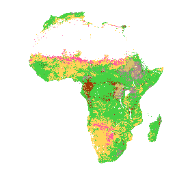
토양 깊이 0~20cm 및 20~50cm의 USDA 텍스처 클래스 밀도가 높은 정글 (일반적으로 아프리카 중부) 지역에서는 모델 정확도가 낮으므로 밴딩 (스트리핑)과 같은 아티팩트가 표시될 수 있습니다. Innovative Solutions for Decision …에서 토양 속성 예측을 수행했습니다. 아프리카 알루미늄 isda soil -
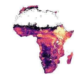
iSDAsoil 추출 가능한 알루미늄
토양 깊이 0~20cm 및 20~50cm에서 추출 가능한 알루미늄, 예측 평균 및 표준 편차 픽셀 값은 exp(x/10)-1로 다시 변환해야 합니다. Innovative Solutions for Decision Agriculture Ltd.(iSDA)는 머신러닝과 결합된 30m(픽셀) 해상도를 사용하여 토양 속성 예측을 수행했습니다. 아프리카 알루미늄 isda soil
Datasets tagged aluminium in Earth Engine
[null,null,[],[[["\u003cp\u003eThis dataset provides soil property predictions for Africa at 30m pixel size, including extractable aluminum, total carbon, effective cation exchange capacity, and USDA texture class.\u003c/p\u003e\n"],["\u003cp\u003ePredictions are available for two soil depths: 0-20 cm and 20-50 cm, and include predicted mean and standard deviation.\u003c/p\u003e\n"],["\u003cp\u003eData is back-transformed using exp(x/10)-1 for analysis.\u003c/p\u003e\n"],["\u003cp\u003eModel accuracy is lower in dense jungle areas (generally over central Africa), potentially leading to artifacts like banding.\u003c/p\u003e\n"],["\u003cp\u003ePredictions were generated by Innovative Solutions for Decision Agriculture Ltd.(iSDA) using machine learning techniques.\u003c/p\u003e\n"]]],["iSDA provides soil data for Africa at 30m pixel size, focusing on depths of 0-20 cm and 20-50 cm. This includes extractable aluminium, total carbon, effective cation exchange capacity, and USDA texture class. Data includes predicted mean and standard deviation. Pixel values require back-transformation using the formula exp(x/10)-1. Model accuracy may be low in dense jungle areas, potentially showing banding artifacts. Machine learning is employed for soil property predictions.\n"],null,["# Datasets tagged aluminium in Earth Engine\n\n-\n\n |-----------------------------------------------------------------------------------------------------------------------------------------------------------------------------------------------------------------------------------------------------------------------------------------------------------------|\n | [### iSDAsoil Effective Cation Exchange Capacity](/earth-engine/datasets/catalog/ISDASOIL_Africa_v1_cation_exchange_capacity) |\n | Effective Cation Exchange Capacity predicted mean and standard deviation at soil depths of 0-20 cm and 20-50 cm, Pixel values must be back-transformed with exp(x/10)-1. In areas of dense jungle (generally over central Africa), model accuracy is low and therefore artifacts such as banding (striping) ... |\n | [africa](/earth-engine/datasets/tags/africa) [aluminium](/earth-engine/datasets/tags/aluminium) [isda](/earth-engine/datasets/tags/isda) [soil](/earth-engine/datasets/tags/soil) |\n\n-\n\n |-----------------------------------------------------------------------------------------------------------------------------------------------------------------------------------------------------------------------------------------------------------------------------------------------------|\n | [### iSDAsoil Total Carbon](/earth-engine/datasets/catalog/ISDASOIL_Africa_v1_carbon_total) |\n | Total carbon at soil depths of 0-20 cm and 20-50 cm, predicted mean and standard deviation. Pixel values must be back-transformed with exp(x/10)-1. In areas of dense jungle (generally over central Africa), model accuracy is low and therefore artifacts such as banding (striping) might be ... |\n | [africa](/earth-engine/datasets/tags/africa) [aluminium](/earth-engine/datasets/tags/aluminium) [isda](/earth-engine/datasets/tags/isda) [soil](/earth-engine/datasets/tags/soil) |\n\n-\n\n |-------------------------------------------------------------------------------------------------------------------------------------------------------------------------------------------------------------------------------------------------------------------------------------------|\n | [### iSDAsoil USDA Texture Class](/earth-engine/datasets/catalog/ISDASOIL_Africa_v1_texture_class) |\n | USDA Texture Class at soil depths of 0-20 cm and 20-50 cm. In areas of dense jungle (generally over central Africa), model accuracy is low and therefore artifacts such as banding (striping) might be seen. Soil property predictions were made by Innovative Solutions for Decision ... |\n | [africa](/earth-engine/datasets/tags/africa) [aluminium](/earth-engine/datasets/tags/aluminium) [isda](/earth-engine/datasets/tags/isda) [soil](/earth-engine/datasets/tags/soil) |\n\n-\n\n |---------------------------------------------------------------------------------------------------------------------------------------------------------------------------------------------------------------------------------------------------------------------------------------------------------------------|\n | [### iSDAsoil extractable Aluminium](/earth-engine/datasets/catalog/ISDASOIL_Africa_v1_aluminium_extractable) |\n | Extractable aluminium at soil depths of 0-20 cm and 20-50 cm, predicted mean and standard deviation. Pixel values must be back-transformed with exp(x/10)-1. Soil property predictions were made by Innovative Solutions for Decision Agriculture Ltd. (iSDA) at 30 m pixel size using machine learning coupled ... |\n | [africa](/earth-engine/datasets/tags/africa) [aluminium](/earth-engine/datasets/tags/aluminium) [isda](/earth-engine/datasets/tags/isda) [soil](/earth-engine/datasets/tags/soil) |"]]