-
RCMAP Rangeland Component Timeseries (1985-2023), v06
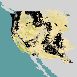
'Der RCMAP-Datensatz (Rangeland Condition Monitoring Assessment and Projection) quantifiziert den prozentualen Anteil der Rangeland-Komponenten in West-Nordamerika anhand von Landsat-Bildern aus dem Zeitraum 1985 bis 2023. Die RCMAP-Produktfamilie besteht aus zehn fraktionierten Komponenten: jährliche krautige Vegetation, unbewachsener Boden, krautige Vegetation, Streu, Nicht-Beifuß-Sträucher, mehrjährige krautige Vegetation, Beifuß usw. climate-change disturbance landsat-derived landuse-landcover nlcd rangeland> -
RCMAP Rangeland Trends Year for Component Timeseries (1985-2023), v06
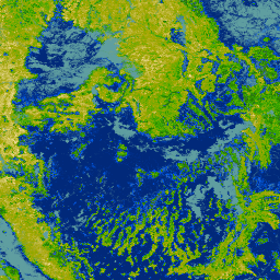
Diese Sammlung umfasst jährliche RCMAP-Produkte von 1985 bis 2023. Im RCMAP-Dataset (Rangeland Condition Monitoring Assessment and Projection) wird der prozentuale Anteil der Rangeland-Komponenten in West-Nordamerika anhand von Landsat-Bildern aus dem Zeitraum 1985 bis 2023 quantifiziert. Die RCMAP-Produktreihe besteht aus zehn fraktionierten Komponenten: jährlich … climate-change disturbance landsat-derived landuse-landcover nlcd rangeland> -
RCMAP Rangeland Trends for Component Timeseries (1985-2023), v06
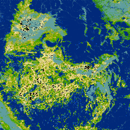
Im RCMAP-Dataset (Rangeland Condition Monitoring Assessment and Projection) wird der prozentuale Anteil der Rangeland-Komponenten in West-Nordamerika anhand von Landsat-Bildern aus dem Zeitraum 1985 bis 2023 quantifiziert. Die RCMAP-Produktfamilie besteht aus zehn fraktionierten Komponenten: jährliche krautige Vegetation, unbewachsener Boden, krautige Vegetation, Streu, Nicht-Beifuß-Sträucher, mehrjährige krautige Vegetation, Beifuß usw. climate-change disturbance landsat-derived landuse-landcover nlcd rangeland>
Datasets tagged disturbance in Earth Engine
[null,null,[],[],["The RCMAP dataset, spanning 1985-2023, uses Landsat imagery to measure the percent cover of ten rangeland components in western North America. These components include annual herbaceous, bare ground, litter, sagebrush, and others. The dataset includes timeseries data, trends, and yearly products, enabling analysis of rangeland changes. This data helps assess climate change, disturbances, and rangeland trends.\n"]]