-
MTBS 소실 지역 경계

Monitoring Trends in Burn Severity (MTBS) 소실 지역 경계 데이터 세트에는 미국 본토, 알래스카, 하와이, 푸에르토리코에서 현재 완료된 모든 MTBS 화재의 소실 지역 범위 다각형이 포함되어 있습니다. NBR은 '정규화된 연소 비율'을 나타내고 dNBR은 … eros fire gtac mtbs table usda -
번 심각도 추세 모니터링 (MTBS) 번 심각도 이미지
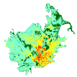
연소 심각도 모자이크는 미국 본토, 알래스카, 하와이, 푸에르토리코에서 현재 완료된 모든 MTBS 화재에 대한 MTBS 연소 심각도 등급의 주제별 래스터 이미지로 구성됩니다. 모자이크 처리된 화상 심각도 이미지는 미국 주별로 매년 컴파일되며 … eros fire forest gtac landcover landsat-derived -
USFS Landscape Change Monitoring System v2024.10 (미국 본토 및 미국 외 지역)
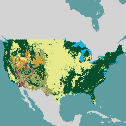
이 제품은 Landscape Change Monitoring System (LCMS) 데이터 모음의 일부입니다. 매년 LCMS 모델링된 변화, 토지 피복, 토지 이용 분류를 보여주며 미국 본토 (CONUS)와 알래스카 (AK), 푸에르토리코 등 미국 본토 외 지역 (OCONUS)을 포함합니다. change-detection forest gtac landcover landuse landuse-landcover -
USFS 트리 캐노피 범위 v2023-5 (미국 본토 및 미국 외 지역)
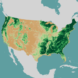
개요 미국 농무부 산림청 (USFS)에서 제작한 수관 밀도 (TCC) 데이터 세트는 1985년부터 2023년까지의 연간 원격 감지 기반 지도 출력입니다. 이 데이터는 미국 지질 조사국에서 관리하는 국토 피복 데이터베이스 (NLCD) 프로젝트를 지원합니다. forest gtac landuse-landcover redcastle-resources usda usfs -
USFS TreeMap v2016 (미국 본토)

이 제품은 TreeMap 데이터 제품군의 일부입니다. 2016년 미국 본토의 전체 산림 범위에 걸쳐 살아 있는 나무와 죽은 나무의 수, 바이오매스, 탄소 등 산림 특성에 관한 자세한 공간 정보를 제공합니다. TreeMap v2016에는 이미지 하나가 포함되어 있습니다. biomass carbon climate-change conus forest forest-biomass -
USFS TreeMap v2020

이 제품은 TreeMap 데이터 제품군의 일부입니다. 2020년 미국 전체 산림 지역의 생존 및 고사 나무 수, 바이오매스, 탄소 등 산림 특성에 관한 자세한 공간 정보를 제공합니다. TreeMap v2020에는 22개 밴드 30x30m … aboveground biomass carbon climate-change conus forest -
USFS TreeMap v2022
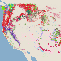
이 제품은 TreeMap 데이터 제품군의 일부입니다. 2022년 미국 전체 산림 지역의 생존 및 고사 나무 수, 바이오매스, 탄소 등 산림 특성에 관한 상세한 공간 정보를 제공합니다. TreeMap v2022에는 22개 밴드, 30x30m … aboveground biomass carbon climate-change conus forest
Datasets tagged gtac in Earth Engine
[null,null,[],[],[]]