-
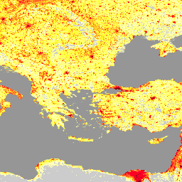
2022년 1월 우크라이나의 LandScan 고해상도 데이터
LandScan 고해상도 (HD)는 3초 (~100m) 해상도로 그리드화된 인구 추정치를 제공합니다. 각 LandScan HD 셀의 값은 대기 (즉, 24시간 평균) 인구 추정치를 나타냅니다. 이렇게 하면 데이터가 과정 전반에서 사용자의 잠재적 활동 공간을 모두 캡처할 수 있습니다. landscan 인구 -
LandScan 인구 데이터 전 세계 1km
오크리지 국립 연구소 (ORNL)에서 제공하는 LandScan 데이터 세트는 포괄적이고 고해상도의 전 세계 인구 분포 데이터 세트를 제공하며, 이는 다양한 애플리케이션에 유용한 리소스입니다. 최신 공간 모델링 기법과 고급 지리정보 데이터 소스를 활용하는 LandScan은 인구 및 인구 밀도에 관한 자세한 정보를 제공합니다. community-dataset demography landscan population sat-io
Datasets tagged landscan in Earth Engine
[null,null,[],[[["\u003cp\u003eLandScan HD provides high-resolution (approximately 100m) gridded population estimates for Ukraine, reflecting the average daily population distribution.\u003c/p\u003e\n"],["\u003cp\u003eLandScan Global offers a 1km resolution global population distribution dataset using advanced spatial modeling and various data sources.\u003c/p\u003e\n"],["\u003cp\u003eBoth datasets are valuable resources for diverse applications requiring population data, with the former focusing on Ukraine and the latter providing a global perspective.\u003c/p\u003e\n"]]],["LandScan HD provides population estimates for Ukraine at a 3 arc-second (~100m) resolution, representing a 24-hour average population count per cell. LandScan Global, from Oak Ridge National Laboratory, offers a high-resolution global population distribution dataset. It utilizes spatial modeling and geospatial data to provide detailed population information for diverse applications. Both datasets are tagged with \"landscan\" and \"population,\" indicating their focus on population distribution analysis.\n"],null,["# Datasets tagged landscan in Earth Engine\n\n-\n\n |----------------------------------------------------------------------------------------------------------------------------------------------------------------------------------------------------------------------------------------------------------------------------------------------------------------------|\n | [### LandScan High Definition Data for Ukraine, January 2022](/earth-engine/datasets/catalog/DOE_ORNL_LandScan_HD_Ukraine_202201) |\n | LandScan High Definition (HD) provides gridded population estimates at 3 arc-second (\\~100m) resolution. Values for each LandScan HD cell represent an ambient (i.e. 24 hour average) population count estimate. In this way, the data capture the full potential activity space of people throughout the course ... |\n | [landscan](/earth-engine/datasets/tags/landscan) [population](/earth-engine/datasets/tags/population) |\n\n-\n\n |-----------------------------------------------------------------------------------------------------------------------------------------------------------------------------------------------------------------------------------------------------------------------------------------------------------------------------------------------------------------|\n | [### LandScan Population Data Global 1km](/earth-engine/datasets/catalog/projects_sat-io_open-datasets_ORNL_LANDSCAN_GLOBAL) |\n | The LandScan dataset, provided by the Oak Ridge National Laboratory (ORNL), offers a comprehensive and high-resolution global population distribution dataset that serves as a valuable resource for a wide range of applications. Leveraging state-of-the-art spatial modeling techniques and advanced geospatial data sources, LandScan provides detailed ... |\n | [community-dataset](/earth-engine/datasets/tags/community-dataset) [demography](/earth-engine/datasets/tags/demography) [landscan](/earth-engine/datasets/tags/landscan) [population](/earth-engine/datasets/tags/population) [sat-io](/earth-engine/datasets/tags/sat-io) |"]]