-
MethaneAIR L3 浓度 V1.1.0

此数据集提供甲烷空气成像光谱仪观测到的甲烷大气柱干空气摩尔分数总量的地理空间数据,即“XCH4”。XCH4 定义为甲烷(“CH4”)的总柱含量(分子数)除以总含量… atmosphere climate edf edf-methanesat-ee emissions ghg -
MethaneAIR L3 浓度 v1

此数据集提供甲烷空气成像光谱仪观测到的甲烷大气柱干空气摩尔分数总量的地理空间数据,即“XCH4”。XCH4 定义为甲烷(“CH4”)的总柱含量(分子数)除以总含量… atmosphere climate edf emissions ghg methane -
MethaneAIR L4 区域源 v1

区域排放模型仍在开发中,不代表最终产品。此数据集使用 MethaneAIR 飞行测量数据(专注于美国各地产油气地区)提供空间上分解的甲烷排放通量 (kg/hr)。调查的总排放量… atmosphere climate edf emissions ghg methane -
MethaneAIR L4 点源 V1.1.0

此数据集提供了 13 个石油和天然气或煤炭开采区域(从西部的科罗拉多州、新墨西哥州和得克萨斯州到东部的宾夕法尼亚州、俄亥俄州和西弗吉尼亚州)以及 3 个城市区域(纽约市、… atmosphere climate edf edf-methanesat-ee emissions ghg -
MethaneAIR L4 点源 v1

此数据集提供了 13 个石油和天然气或煤炭开采区域(从西部的科罗拉多州、新墨西哥州和得克萨斯州到东部的宾夕法尼亚州、俄亥俄州和西弗吉尼亚州)以及 3 个城市区域(纽约市、… atmosphere climate edf emissions ghg methane -
OGIM:石油和天然气基础设施测绘数据库 v2.5.1
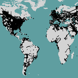
此数据集提供了全球范围内与石油和天然气 (O&G) 相关的基础设施的位置。石油和天然气基础设施地图 (OGIM) 数据库是由美国环保协会 (EDF) 和 MethaneSAT LLC(EDF 的全资子公司)共同开发的项目。开发…的主要目标是… edf 排放 ghg 基础设施边界 甲烷 甲烷空气
Datasets tagged methaneair in Earth Engine
[null,null,[],[],[]]