-
GLIMS 2023:从太空测量全球陆地冰川
全球陆地冰从太空测量 (GLIMS) 是一项国际计划,旨在反复调查全球估计 20 万座冰川。该项目旨在创建全球全面的陆地冰资源清单,包括测量冰川面积、几何形状、表面速度和雪线… 冰冻圈 冰川 glims 冰 土地覆盖 NASA -
GLIMS Current:从太空测量全球陆地冰川
全球陆地冰从太空测量 (GLIMS) 是一项国际计划,旨在反复调查全球估计 20 万座冰川。该项目旨在创建全球全面的陆地冰资源清单,包括测量冰川面积、几何形状、表面速度和雪线… 冰冻圈 冰川 glims 冰 土地覆盖 NASA -
MOD10A1.061 Terra 雪盖全球每日 500 米
MOD10A1 V6.1 全球每日雪盖面积 500 米产品包含雪盖面积、雪面反照率、雪盖百分比和质量评估 (QA) 数据。积雪数据基于采用标准化差异积雪指数 (NDSI) 和其他条件测试的积雪绘图算法。常规… 反射率 冰冻圈 每日 地球物理 全球 MODIS -
MOD10A2.061 Terra 积雪 8 天 L3 全球 500 米
MOD10A2 是 Terra 卫星上的 MODIS 提供的积雪数据集。该数据集报告了 8 天内最大雪覆盖范围,分辨率为 500 米。之所以选择 8 天的时间段进行合成,是因为这是地面轨道的确切重复周期… 冰冻圈 每日 地球物理 全球 MODIS NASA -
MYD10A1.061 Aqua 积雪量每日全球 500 米
MYD10A1 V6 全球每日雪盖面积 500 米产品包含雪盖面积、雪面反照率、雪盖百分比和质量评估 (QA) 数据。积雪数据基于采用标准化差异积雪指数 (NDSI) 和其他条件测试的积雪绘图算法。常规… 反射率 水域 冰冻圈 每日 地球物理 全球
Datasets tagged nsidc in Earth Engine
[null,null,[],[[["\u003cp\u003eGLIMS repeatedly surveys the world's glaciers to create a comprehensive inventory, including measurements of glacier area, geometry, surface velocity, and snow line.\u003c/p\u003e\n"],["\u003cp\u003eMOD10A1.061 provides daily global snow cover information, including snow albedo and fractional snow cover, using a Normalized Difference Snow Index (NDSI).\u003c/p\u003e\n"],["\u003cp\u003eMYD10A1.061 offers similar daily global snow cover data as MOD10A1.061 but is derived from the Aqua satellite instead of Terra.\u003c/p\u003e\n"]]],["GLIMS aims to inventory 200,000 glaciers globally, measuring area, geometry, surface velocity, and snow line. MOD10A1 provides daily global snow cover data, including albedo and fractional cover, at 500m resolution, using an NDSI-based algorithm. MOD10A2 tracks the maximum snow cover extent over eight-day periods at 500m resolution. MYD10A1 similarly offers daily global snow data, including albedo and fractional snow cover, at 500m, and is based on an NDSI algorithm.\n"],null,["# Datasets tagged nsidc in Earth Engine\n\n-\n\n |--------------------------------------------------------------------------------------------------------------------------------------------------------------------------------------------------------------------------------------------------------------------------------------------------------------------------------|\n | [### GLIMS 2023: Global Land Ice Measurements From Space](/earth-engine/datasets/catalog/GLIMS_20230607) |\n | Global Land Ice Measurements from Space (GLIMS) is an international initiative with the goal of repeatedly surveying the world's estimated 200,000 glaciers. The project seeks to create a globally comprehensive inventory of land ice, including measurements of glacier area, geometry, surface velocity, and snow line ... |\n | [cryosphere](/earth-engine/datasets/tags/cryosphere) [glacier](/earth-engine/datasets/tags/glacier) [glims](/earth-engine/datasets/tags/glims) [ice](/earth-engine/datasets/tags/ice) [landcover](/earth-engine/datasets/tags/landcover) [nasa](/earth-engine/datasets/tags/nasa) |\n\n-\n\n |--------------------------------------------------------------------------------------------------------------------------------------------------------------------------------------------------------------------------------------------------------------------------------------------------------------------------------|\n | [### GLIMS Current: Global Land Ice Measurements From Space](/earth-engine/datasets/catalog/GLIMS_current) |\n | Global Land Ice Measurements from Space (GLIMS) is an international initiative with the goal of repeatedly surveying the world's estimated 200,000 glaciers. The project seeks to create a globally comprehensive inventory of land ice, including measurements of glacier area, geometry, surface velocity, and snow line ... |\n | [cryosphere](/earth-engine/datasets/tags/cryosphere) [glacier](/earth-engine/datasets/tags/glacier) [glims](/earth-engine/datasets/tags/glims) [ice](/earth-engine/datasets/tags/ice) [landcover](/earth-engine/datasets/tags/landcover) [nasa](/earth-engine/datasets/tags/nasa) |\n\n-\n\n |-----------------------------------------------------------------------------------------------------------------------------------------------------------------------------------------------------------------------------------------------------------------------------------------------------|\n | [### 
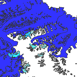
MOD10A1.061 Terra Snow Cover Daily Global 500m](/earth-engine/datasets/catalog/MODIS_061_MOD10A1) |\n | The MOD10A1 V6.1 Snow Cover Daily Global 500m product contains snow cover, snow albedo, fractional snow cover, and quality assessment (QA) data. Snow cover data are based on a snow mapping algorithm that employs a Normalized Difference Snow Index (NDSI) and other criteria tests. General ... |\n | [albedo](/earth-engine/datasets/tags/albedo) [cryosphere](/earth-engine/datasets/tags/cryosphere) [daily](/earth-engine/datasets/tags/daily) [geophysical](/earth-engine/datasets/tags/geophysical) [global](/earth-engine/datasets/tags/global) [modis](/earth-engine/datasets/tags/modis) |\n\n-\n\n |-----------------------------------------------------------------------------------------------------------------------------------------------------------------------------------------------------------------------------------------------------------------------------------------|\n | [### MOD10A2.061 Terra Snow Cover 8-Day L3 Global 500m](/earth-engine/datasets/catalog/MODIS_061_MOD10A2) |\n | MOD10A2 is a snow cover dataset from the MODIS on the Terra satellite. The dataset reports the maximum snow cover extent during an eight-day period at the resolution of 500 m. An eight-day compositing period was chosen because that is the exact ground track repeat ... |\n | [cryosphere](/earth-engine/datasets/tags/cryosphere) [daily](/earth-engine/datasets/tags/daily) [geophysical](/earth-engine/datasets/tags/geophysical) [global](/earth-engine/datasets/tags/global) [modis](/earth-engine/datasets/tags/modis) [nasa](/earth-engine/datasets/tags/nasa) |\n\n-\n\n |---------------------------------------------------------------------------------------------------------------------------------------------------------------------------------------------------------------------------------------------------------------------------------------------------|\n | [### MYD10A1.061 Aqua Snow Cover Daily Global 500m](/earth-engine/datasets/catalog/MODIS_061_MYD10A1) |\n | The MYD10A1 V6 Snow Cover Daily Global 500m product contains snow cover, snow albedo, fractional snow cover, and quality assessment (QA) data. Snow cover data are based on a snow mapping algorithm that employs a Normalized Difference Snow Index (NDSI) and other criteria tests. General ... |\n | [albedo](/earth-engine/datasets/tags/albedo) [aqua](/earth-engine/datasets/tags/aqua) [cryosphere](/earth-engine/datasets/tags/cryosphere) [daily](/earth-engine/datasets/tags/daily) [geophysical](/earth-engine/datasets/tags/geophysical) [global](/earth-engine/datasets/tags/global) |"]]