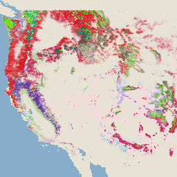
-
监控烧屏严重程度 (MTBS) 烧屏严重程度图片的趋势
烧伤严重程度拼接图由 MTBS 烧伤严重程度类别的主题光栅图像组成,涵盖美国本土、阿拉斯加、夏威夷和波多黎各目前所有已完成的 MTBS 火灾。我们每年都会按美国各州和哥伦比亚特区编制经过马赛克处理的火烧严重程度图片,以便… eros fire forest gtac landcover landsat-derived -
USFS Landscape Change Monitoring System v2024.10(美国本土和美国境外)
此产品属于景观变化监测系统 (LCMS) 数据套件。该数据集显示了 LCMS 模型模拟的每年变化、土地覆盖和/或土地利用类别,涵盖美国大陆 (CONUS) 以及美国大陆以外 (OCONUS) 的区域,包括阿拉斯加州 (AK)、波多黎各、美属维尔京群岛、美属 … change-detection forest gtac landcover landuse landuse-landcover -
USFS 树冠覆盖率 v2023-5(美国本土和美国境外)
此产品属于树冠覆盖率 (TCC) 数据套件。其中包含每年的模拟 TCC、标准误差 (SE) 和美国国家土地覆盖数据库 (NLCD) 的 TCC 数据。美国农业部森林服务局 (USFS) 生成的 TCC 数据具有以下特点: forest gtac landuse-landcover redcastle-resources usda usfs -
USFS TreeMap v2016(美国大陆)
此产品属于 TreeMap 数据套件。该数据集提供了有关 2016 年美国大陆整个森林区域的森林特征(包括活树和枯树数量、生物量和碳含量)的详细空间信息。TreeMap v2016 包含一张图片,一个… 生物质 碳 气候变化 conus 森林 森林生物质
Datasets tagged redcastle-resources in Earth Engine
[null,null,[],[[["\u003cp\u003eThe MTBS dataset provides annual burn severity mosaics for fires across the US, including Alaska, Hawaii, and Puerto Rico.\u003c/p\u003e\n"],["\u003cp\u003eThe USFS TreeMap v2016 dataset offers detailed forest characteristic information for the continental United States, including tree counts, biomass, and carbon estimates.\u003c/p\u003e\n"],["\u003cp\u003eThe USFS Tree Canopy Cover v2021-4 dataset includes modeled and NLCD tree canopy cover data, along with standard error, for the continental US and other US territories.\u003c/p\u003e\n"]]],[],null,["# Datasets tagged redcastle-resources in Earth Engine\n\n-\n\n |------------------------------------------------------------------------------------------------------------------------------------------------------------------------------------------------------------------------------------------------------------------------------------------------|\n | [### Monitoring Trends in Burn Severity (MTBS) Burn Severity Images](/earth-engine/datasets/catalog/USFS_GTAC_MTBS_annual_burn_severity_mosaics_v1) |\n | The burn severity mosaics consist of thematic raster images of MTBS burn severity classes for all currently completed MTBS fires for the continental United States, Alaska, Hawaii and Puerto Rico. Mosaicked burn severity images are compiled annually for each year by US State and the ... |\n | [eros](/earth-engine/datasets/tags/eros) [fire](/earth-engine/datasets/tags/fire) [forest](/earth-engine/datasets/tags/forest) [gtac](/earth-engine/datasets/tags/gtac) [landcover](/earth-engine/datasets/tags/landcover) [landsat-derived](/earth-engine/datasets/tags/landsat-derived) |\n\n-\n\n |-----------------------------------------------------------------------------------------------------------------------------------------------------------------------------------------------------------------------------------------------------------------------------------------------------------------------------|\n | [### USFS Landscape Change Monitoring System v2024.10 (CONUS and OCONUS)](/earth-engine/datasets/catalog/USFS_GTAC_LCMS_v2024-10) |\n | This product is part of the Landscape Change Monitoring System (LCMS) data suite. It shows LCMS-modeled change, land cover, and/or land use classes for each year and covers the Conterminous United States (CONUS) as well as areas outside the CONUS (OCONUS) including Alaska (AK), Puerto ... |\n | [change-detection](/earth-engine/datasets/tags/change-detection) [forest](/earth-engine/datasets/tags/forest) [gtac](/earth-engine/datasets/tags/gtac) [landcover](/earth-engine/datasets/tags/landcover) [landuse](/earth-engine/datasets/tags/landuse) [landuse-landcover](/earth-engine/datasets/tags/landuse-landcover) |\n\n-\n\n |-------------------------------------------------------------------------------------------------------------------------------------------------------------------------------------------------------------------------------------------------------------------------------------------------------------------|\n | [### USFS Tree Canopy Cover v2023-5 (CONUS and OCONUS)](/earth-engine/datasets/catalog/USGS_NLCD_RELEASES_2023_REL_TCC_v2023-5) |\n | This product is part of the Tree Canopy Cover (TCC) data suite. It includes modeled TCC, standard error (SE), and National Land Cover Database's (NLCD) TCC data for each year. TCC data produced by the the United States Department of Agriculture, Forest Service (USFS) are ... |\n | [forest](/earth-engine/datasets/tags/forest) [gtac](/earth-engine/datasets/tags/gtac) [landuse-landcover](/earth-engine/datasets/tags/landuse-landcover) [redcastle-resources](/earth-engine/datasets/tags/redcastle-resources) [usda](/earth-engine/datasets/tags/usda) [usfs](/earth-engine/datasets/tags/usfs) |\n\n-\n\n |---------------------------------------------------------------------------------------------------------------------------------------------------------------------------------------------------------------------------------------------------------------------------------------------------------------|\n | [### USFS TreeMap v2016 (Conterminous United States)](/earth-engine/datasets/catalog/USFS_GTAC_TreeMap_v2016) |\n | This product is part of the TreeMap data suite. It provides detailed spatial information on forest characteristics including number of live and dead trees, biomass, and carbon across the entire forested extent of the continental United States in 2016. TreeMap v2016 contains one image, a ... |\n | [biomass](/earth-engine/datasets/tags/biomass) [carbon](/earth-engine/datasets/tags/carbon) [climate-change](/earth-engine/datasets/tags/climate-change) [conus](/earth-engine/datasets/tags/conus) [forest](/earth-engine/datasets/tags/forest) [forest-biomass](/earth-engine/datasets/tags/forest-biomass) |\n\n-\n\n |---------------------------------------------------------------------------------------------------------------------------------------------------------------------------------------------------------------------------------------------------------------------------------------------------------|\n | [### USFS TreeMap v2020](/earth-engine/datasets/catalog/USFS_GTAC_TreeMap_v2020) |\n | This product is part of the TreeMap data suite. It provides detailed spatial information on forest characteristics including number of live and dead trees, biomass, and carbon across the entire forested extent of the United States in 2020. TreeMap v2020 contains 22-band 30 x 30m ... |\n | [aboveground](/earth-engine/datasets/tags/aboveground) [biomass](/earth-engine/datasets/tags/biomass) [carbon](/earth-engine/datasets/tags/carbon) [climate-change](/earth-engine/datasets/tags/climate-change) [conus](/earth-engine/datasets/tags/conus) [forest](/earth-engine/datasets/tags/forest) |\n\n-\n\n |---------------------------------------------------------------------------------------------------------------------------------------------------------------------------------------------------------------------------------------------------------------------------------------------------------|\n | [### USFS TreeMap v2022](/earth-engine/datasets/catalog/USFS_GTAC_TreeMap_v2022) |\n | This product is part of the TreeMap data suite. It provides detailed spatial information on forest characteristics including number of live and dead trees, biomass, and carbon across the entire forested extent of the United States in 2022. TreeMap v2022 contains 22-band 30 x 30m ... |\n | [aboveground](/earth-engine/datasets/tags/aboveground) [biomass](/earth-engine/datasets/tags/biomass) [carbon](/earth-engine/datasets/tags/carbon) [climate-change](/earth-engine/datasets/tags/climate-change) [conus](/earth-engine/datasets/tags/conus) [forest](/earth-engine/datasets/tags/forest) |"]]