-
GHSL:城镇化程度 1975-2030 V2-0 (P2023A)
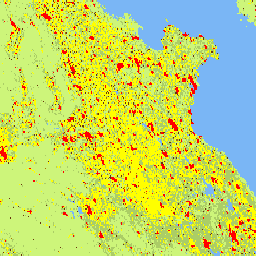
此栅格数据集表示全球多时相城乡分类,应用了联合国统计委员会推荐的“城镇化程度”第一阶段方法,基于 GHSL 项目生成的 1975-2030 年间(以 5 年为间隔)全球网格化人口和建成区地表面积数据。城镇化程度 … ghsl jrc population sdg settlement -
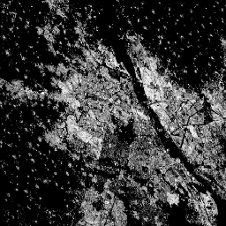
GHSL:全球建成区地表面积 10 米 (P2023A)

此栅格数据集描绘了 2018 年从 S2 图像数据中观察到的建成区地表面积分布情况,以每 10 米网格单元的平方米数表示。数据集衡量了:a) 建成区地表面积总和,以及 b) 分配给 … built built-environment builtup copernicus ghsl jrc -
GHSL:全球建成区地表面积 1975-2030 (P2023A)
此栅格数据集描绘了建成区地表面积分布情况,以每 100 米网格单元的平方米数表示。数据集衡量了:a) 建成区地表面积总和,以及 b) 分配给以非住宅 (NRES) 为主的网格单元的建成区地表面积。数据在空间和时间上经过插值或 … built built-environment builtup copernicus ghsl jrc -
GHSL:全球居住地特征 (10 米) 2018 (P2023A)
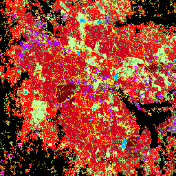
此空间栅格数据集以 10 米分辨率划定了人类居住地,并根据建成环境的功能和高度相关组成部分描述了居住地的内部特征。如需详细了解 GHSL 数据产品,请参阅 GHSL Data Package 2023 报告 … building built builtup copernicus ghsl height -
世界居住地足迹 2015

世界居住地足迹 (WSF) 2015 是一个 10 米分辨率的二元掩码,用于勾勒全球人类居住地的范围,通过 2014-2015 年多时相 Landsat-8 和 Sentinel-1 影像(分别处理了约 217,000 个和约 107,000 个场景)得出。人类居住地的时间动态 … landcover landsat-derived population sentinel1-derived settlement urban
Datasets tagged settlement in Earth Engine
[null,null,[],[],[]]