-
ArcticDEM 马赛克 V4.1
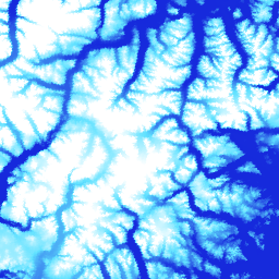
ArcticDEM 是美国国家地理空间情报局 (NGA) 和美国国家科学基金会 (NSF) 共同发起的一项公私合作计划,旨在利用光学立体影像、高性能计算和开源摄影测量软件,自动生成北极的高分辨率、高质量数字表面模型 (DSM)。它包括植被、树冠、建筑物等。 arctic dem elevation-topography geophysical pgc umn -
ArcticDEM 条状
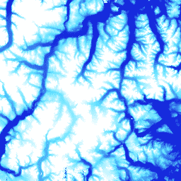
ArcticDEM 是美国国家地理空间情报局 (NGA) 和美国国家科学基金会 (NSF) 共同发起的一项公私合作计划,旨在利用光学立体影像、高性能计算和开源摄影测量软件,自动生成北极的高分辨率、高质量数字表面模型 (DSM)。它包括植被、树冠、建筑物等。 arctic dem elevation-topography geophysical pgc umn -
REMA 马赛克

南极参考高程模型 (REMA) 是南极洲的高分辨率、带时间戳的数字表面模型 (DSM),空间分辨率为 2 米和 8 米。马赛克 DEM 文件由多个条状影像编译而成,这些条状影像经过共同配准、混合和羽化处理,以减少边缘匹配伪影。 dem elevation-topography geophysical pgc rema umn -
REMA 条状 2 米

南极参考高程模型 (REMA) 是南极洲的高分辨率、带时间戳的数字表面模型 (DSM),空间分辨率为 2 米和 8 米。条状 DEM 文件对应于 DigitalGlobe 的输入立体影像对条状影像在收集时重叠的区域。 dem elevation-topography geophysical pgc rema umn -
REMA 条状 8 米

南极参考高程模型 (REMA) 是南极洲的高分辨率、带时间戳的数字表面模型 (DSM),空间分辨率为 2 米和 8 米。条状 DEM 文件对应于 DigitalGlobe 的输入立体影像对条状影像在收集时重叠的区域。 dem elevation-topography geophysical pgc rema umn
Datasets tagged umn in Earth Engine
[null,null,[],[],[]]