Ground Overlays
Stay organized with collections
Save and categorize content based on your preferences.
Ground overlays are overlays on the map that are tied to latitude/longitude
coordinates, so they move when you drag or zoom the map.

Introduction
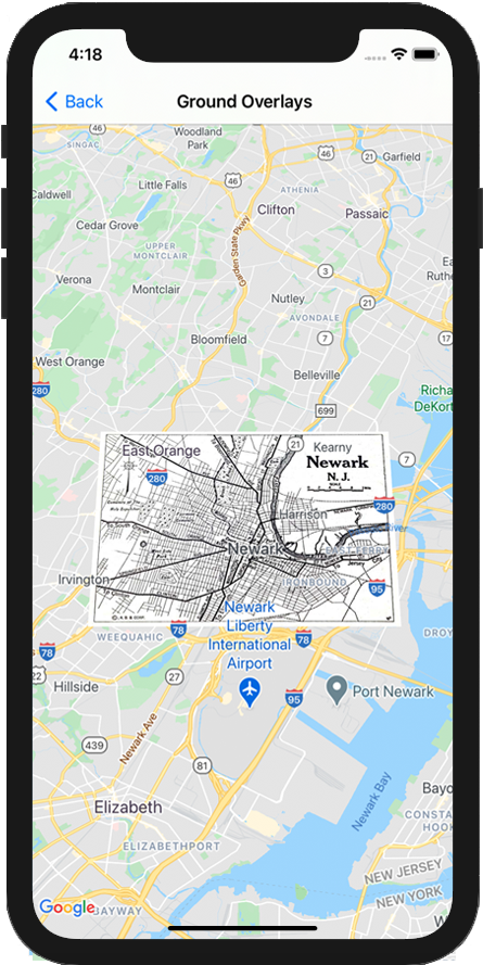
A ground overlay is an image that is fixed to a map. Unlike
markers, ground overlays are oriented against the Earth's surface
rather than the screen, so rotating, tilting or zooming the map will change
the orientation of the image.
To add a ground overlay, create a
GMSGroundOverlay
object that defines both an icon and a bounds. Failing to specify either will
cause the ground overlay to not appear on the map. You can optionally specify
additional settings that will affect the positioning of the image on the map.
Once you've defined the necessary options, set this object's map
property to
add the overlay.
Adding an overlay
- Instantiate a new
GMSGroundOverlay
object
- Set the
icon
property to an instance of UIImage
.
- Set the
bounds
property to an instance of GMSCoordinateBounds
. The
bounds represent the south west, and north east corners of the image.
- Set optional properties, such as
bearing
and zoomLevel
, as desired.
- Set the
map
property - the image appears on the map.
The below example demonstrates how to add a ground overlay to an existing
GMSMapView
object.
Swift
let southWest = CLLocationCoordinate2D(latitude: 40.712216, longitude: -74.22655)
let northEast = CLLocationCoordinate2D(latitude: 40.773941, longitude: -74.12544)
let overlayBounds = GMSCoordinateBounds(coordinate: southWest, coordinate: northEast)
// Image from http://www.lib.utexas.edu/maps/historical/newark_nj_1922.jpg
let icon = UIImage(named: "newark_nj_1922")
let overlay = GMSGroundOverlay(bounds: overlayBounds, icon: icon)
overlay.bearing = 0
overlay.map = mapView
Objective-C
CLLocationCoordinate2D southWest = CLLocationCoordinate2DMake(40.712216,-74.22655);
CLLocationCoordinate2D northEast = CLLocationCoordinate2DMake(40.773941,-74.12544);
GMSCoordinateBounds *overlayBounds = [[GMSCoordinateBounds alloc] initWithCoordinate:southWest
coordinate:northEast];
// Image from http://www.lib.utexas.edu/maps/historical/newark_nj_1922.jpg
UIImage *icon = [UIImage imageNamed:@"newark_nj_1922"];
GMSGroundOverlay *overlay = [GMSGroundOverlay groundOverlayWithBounds:overlayBounds icon:icon];
overlay.bearing = 0;
overlay.map = mapView;
Removing an overlay
You can remove a ground overlay from the map by setting your
GMSGroundOverlay
's map
property to nil
. Alternately, you can remove all
of the overlays (including ground overlays currently on the map by calling the
GMSMapView
clear
method.
Objective-C
[mapView clear];
If you wish to make modifications to a ground overlay after you've added it to
the map, ensure that you keep hold of the GMSGroundOverlay
object. You can
modify the ground overlay later by making changes to this object.
Swift
let overlay = GMSGroundOverlay(bounds: overlayBounds, icon: icon)
overlay.bearing = 0
overlay.map = mapView
// ...
overlay.isTappable = true
Objective-C
GMSGroundOverlay *overlay = [GMSGroundOverlay groundOverlayWithBounds:overlayBounds icon:icon];
overlay.bearing = 0;
overlay.map = mapView;
// ...
overlay.tappable = YES;
Events
You can listen to events that occur on the map, such as when a user taps an
overlay. To listen to events, you must implement the
GMSMapViewDelegate
protocol. See the
guide to events and the list of methods on the
GMSMapViewDelegate
.
Except as otherwise noted, the content of this page is licensed under the Creative Commons Attribution 4.0 License, and code samples are licensed under the Apache 2.0 License. For details, see the Google Developers Site Policies. Java is a registered trademark of Oracle and/or its affiliates.
Last updated 2025-08-28 UTC.
[null,null,["Last updated 2025-08-28 UTC."],[[["\u003cp\u003eGround overlays are images fixed to a map, oriented to the Earth's surface, and change orientation with map interactions.\u003c/p\u003e\n"],["\u003cp\u003eTo add a ground overlay, create a \u003ccode\u003eGMSGroundOverlay\u003c/code\u003e object, define its icon, bounds, and optional settings, then set its \u003ccode\u003emap\u003c/code\u003e property.\u003c/p\u003e\n"],["\u003cp\u003eGround overlays can be removed by setting the \u003ccode\u003emap\u003c/code\u003e property to \u003ccode\u003enil\u003c/code\u003e or using the \u003ccode\u003eclear\u003c/code\u003e method on the \u003ccode\u003eGMSMapView\u003c/code\u003e.\u003c/p\u003e\n"],["\u003cp\u003eModifications to existing ground overlays can be made by accessing and updating the \u003ccode\u003eGMSGroundOverlay\u003c/code\u003e object directly.\u003c/p\u003e\n"],["\u003cp\u003eImplement the \u003ccode\u003eGMSMapViewDelegate\u003c/code\u003e protocol to listen to events like user taps on the overlay.\u003c/p\u003e\n"]]],["Ground overlays, images fixed to a map using latitude/longitude, are added by creating a `GMSGroundOverlay` object. This requires setting both the `icon` (an image) and `bounds` (southwest/northeast coordinates). Optionally, set properties like `bearing` and `zoomLevel`. To display, assign the object's `map` property. Overlays are removed by setting `map` to `nil` or using the `clear` method. Modifications require retaining the `GMSGroundOverlay` object and to listen for events, you must implement `GMSMapViewDelegate`.\n"],null,["Select platform: [Android](/maps/documentation/android-sdk/groundoverlay \"View this page for the Android platform docs.\") [iOS](/maps/documentation/ios-sdk/overlays \"View this page for the iOS platform docs.\") [JavaScript](/maps/documentation/javascript/groundoverlays \"View this page for the JavaScript platform docs.\")\n\n\u003cbr /\u003e\n\nGround overlays are overlays on the map that are tied to latitude/longitude\ncoordinates, so they move when you drag or zoom the map.\n\nIntroduction\n\nA ground overlay is an image that is fixed to a map. Unlike\n[markers](/maps/documentation/ios-sdk/marker), ground overlays are oriented against the Earth's surface\nrather than the screen, so rotating, tilting or zooming the map will change\nthe orientation of the image.\n\nTo add a ground overlay, create a\n[`GMSGroundOverlay`](/maps/documentation/ios-sdk/reference/objc/Classes/GMSGroundOverlay)\nobject that defines both an icon and a bounds. Failing to specify either will\ncause the ground overlay to not appear on the map. You can optionally specify\nadditional settings that will affect the positioning of the image on the map.\nOnce you've defined the necessary options, set this object's `map` property to\nadd the overlay.\n\nAdding an overlay\n\n1. Instantiate a new `GMSGroundOverlay` object\n2. Set the `icon` property to an instance of `UIImage`.\n3. Set the `bounds` property to an instance of `GMSCoordinateBounds`. The bounds represent the south west, and north east corners of the image.\n4. Set optional properties, such as `bearing` and `zoomLevel`, as desired.\n5. Set the `map` property - the image appears on the map.\n\nThe below example demonstrates how to add a ground overlay to an existing\n`GMSMapView` object.\n\n\nSwift \n\n```swift\nlet southWest = CLLocationCoordinate2D(latitude: 40.712216, longitude: -74.22655)\nlet northEast = CLLocationCoordinate2D(latitude: 40.773941, longitude: -74.12544)\nlet overlayBounds = GMSCoordinateBounds(coordinate: southWest, coordinate: northEast)\n\n// Image from http://www.lib.utexas.edu/maps/historical/newark_nj_1922.jpg\nlet icon = UIImage(named: \"newark_nj_1922\")\n\nlet overlay = GMSGroundOverlay(bounds: overlayBounds, icon: icon)\noverlay.bearing = 0\noverlay.map = mapView\n \n```\n\nObjective-C \n\n```objective-c\nCLLocationCoordinate2D southWest = CLLocationCoordinate2DMake(40.712216,-74.22655);\nCLLocationCoordinate2D northEast = CLLocationCoordinate2DMake(40.773941,-74.12544);\nGMSCoordinateBounds *overlayBounds = [[GMSCoordinateBounds alloc] initWithCoordinate:southWest\n coordinate:northEast];\n\n// Image from http://www.lib.utexas.edu/maps/historical/newark_nj_1922.jpg\nUIImage *icon = [UIImage imageNamed:@\"newark_nj_1922\"];\nGMSGroundOverlay *overlay = [GMSGroundOverlay groundOverlayWithBounds:overlayBounds icon:icon];\noverlay.bearing = 0;\noverlay.map = mapView;\n \n```\n\n\u003cbr /\u003e\n\nRemoving an overlay\n\nYou can remove a ground overlay from the map by setting your\n`GMSGroundOverlay`'s `map` property to `nil`. Alternately, you can remove all\nof the overlays (including ground overlays currently on the map by calling the\n`GMSMapView` `clear` method.\n\n\nSwift \n\n```swift\nmapView.clear()\n \n```\n\nObjective-C \n\n```objective-c\n[mapView clear];\n \n```\n\n\u003cbr /\u003e\n\nIf you wish to make modifications to a ground overlay after you've added it to\nthe map, ensure that you keep hold of the `GMSGroundOverlay` object. You can\nmodify the ground overlay later by making changes to this object.\n\n\nSwift \n\n```swift\nlet overlay = GMSGroundOverlay(bounds: overlayBounds, icon: icon)\noverlay.bearing = 0\noverlay.map = mapView\n\n// ...\n\noverlay.isTappable = true\n \n```\n\nObjective-C \n\n```objective-c\nGMSGroundOverlay *overlay = [GMSGroundOverlay groundOverlayWithBounds:overlayBounds icon:icon];\noverlay.bearing = 0;\noverlay.map = mapView;\n\n// ...\noverlay.tappable = YES;\n \n```\n\n\u003cbr /\u003e\n\nEvents\n\nYou can listen to events that occur on the map, such as when a user taps an\noverlay. To listen to events, you must implement the\n[`GMSMapViewDelegate`](/maps/documentation/ios-sdk/reference/objc/Protocols/GMSMapViewDelegate) protocol. See the\n[guide to events](/maps/documentation/ios-sdk/events) and the list of methods on the\n[`GMSMapViewDelegate`](/maps/documentation/ios-sdk/reference/objc/Protocols/GMSMapViewDelegate)."]]