
Maps JavaScript API 提供了两种不同的地图实现方式:光栅和矢量。光栅地图以基于像素的光栅图像图块网格形式加载地图,这些图块由 Google Maps Platform 服务器端生成,然后提供给您的 Web 应用。矢量地图由基于矢量的图块组成,这些图块在加载时使用 WebGL(一种允许浏览器访问用户设备上的 GPU 以渲染 2D 和 3D 图形的 Web 技术)在客户端绘制。
建议使用矢量地图类型,以获得最佳用户体验,因为它可以提高视觉保真度,改进地图缓存,并能够控制地图上的倾斜度和朝向。详细了解矢量地图功能。
默认渲染类型
地图的默认渲染类型因实现而异。
使用
<gmp-map>元素的地图默认采用矢量渲染类型。使用
<div>元素且google.maps.Map为默认值的地图采用的是栅格渲染类型。
通过指定 renderingType 地图选项或在关联的地图 ID 上设置相应选项,来设置地图的渲染类型。renderingType 选项会替换通过配置地图 ID 进行的任何渲染类型设置。
指定 renderingType 选项
使用 renderingType 选项可为地图指定光栅或矢量渲染类型(无需地图 ID)。对于使用 div 元素和 JavaScript 加载的地图,默认渲染类型为 google.maps.RenderingType.RASTER。请按以下步骤设置renderingType选项:
加载
RenderingType库;这可以在加载 Maps 库时完成:const { Map, RenderingType } = await google.maps.importLibrary("maps");初始化地图时,请使用
renderingType选项指定RenderingType.VECTOR或RenderingType.RASTER:map = new Map( document.getElementById('map'), { zoom: 4, center: position, renderingType: RenderingType.VECTOR, } );
设置矢量地图渲染类型后,您必须为所需的功能设置相应选项。
- 如需启用倾斜,请将
tiltInteractionEnabled地图选项设置为true或调用map.setTiltInteractionEnabled(true)。 - 如需启用平移,请将
headingInteractionEnabled地图选项设置为true或调用map.setHeadingInteractionEnabled(true)。
对于使用 <gmp-map> 元素加载的地图,默认渲染类型为 google.maps.RenderingType.VECTOR,并且启用了倾斜度和朝向控制。如需使用 <gmp-map> 元素设置渲染类型,请使用 rendering-type 属性。
使用地图 ID 设置渲染类型
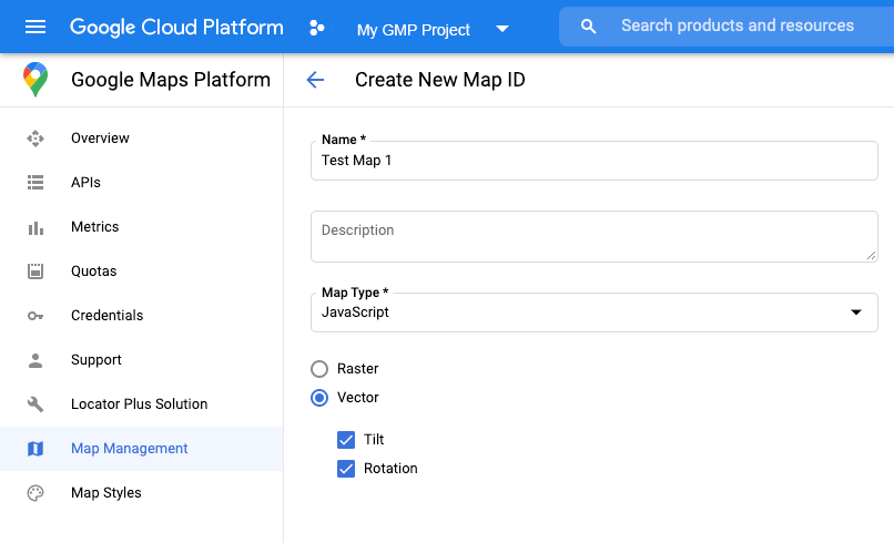
您还可以使用地图 ID 指定渲染类型。按照使用云端地图样式设置 - 获取地图 ID 一文中的步骤创建地图 ID。 请务必将地图类型设置为 JavaScript,然后选择一个选项(矢量或光栅)。选中倾斜和旋转,以在地图上启用倾斜和旋转。这样一来,您便能以程序化方式调整这些值,还能让用户直接在地图上调整倾斜度和朝向。如果使用倾斜或朝向会对应用产生不利影响,则不要选中倾斜和旋转,这样用户就无法调整倾斜度和旋转度。
接下来,使用您创建的地图 ID 更新地图初始化代码。您可以在地图管理页面上找到地图 ID。在实例化地图时,请通过 mapId 属性提供地图 ID,如下所示:
map = new google.maps.Map(document.getElementById('map'), {
  center: {lat: -34.397, lng: 150.644},
  zoom: 8,
  mapId: 'MAP_ID'
});
检测正在使用的渲染类型
如需检测所使用的渲染类型,请对地图对象调用 getRenderingType(),如以下示例所示:
  // Wait for the map to finish loading.
  google.maps.event.addListenerOnce(map, "tilesloaded", () => {
      // Print the rendering type to the console.
      console.log(`${map.getRenderingType()}`);
  });```