Element wysokości
Zadbaj o dobrą organizację dzięki kolekcji
Zapisuj i kategoryzuj treści zgodnie ze swoimi preferencjami.
Podnoszenie uprawnień w samodzielnym elemencie
ElevationElement
to element HTML, który wizualizuje dane wysokościowe dla pojedynczego punktu lub polilinii. Pokazuje on wykres wzniesienia wzdłuż ścieżki ustawionej w właściwości
path
z użyciem tablicy współrzędnych szerokości i długości geograficznej. Odcinki linii są interpolowane między punktami tablicy, więc nawet niewielka liczba punktów pozwoli uzyskać szczegółowy wykres wysokości.
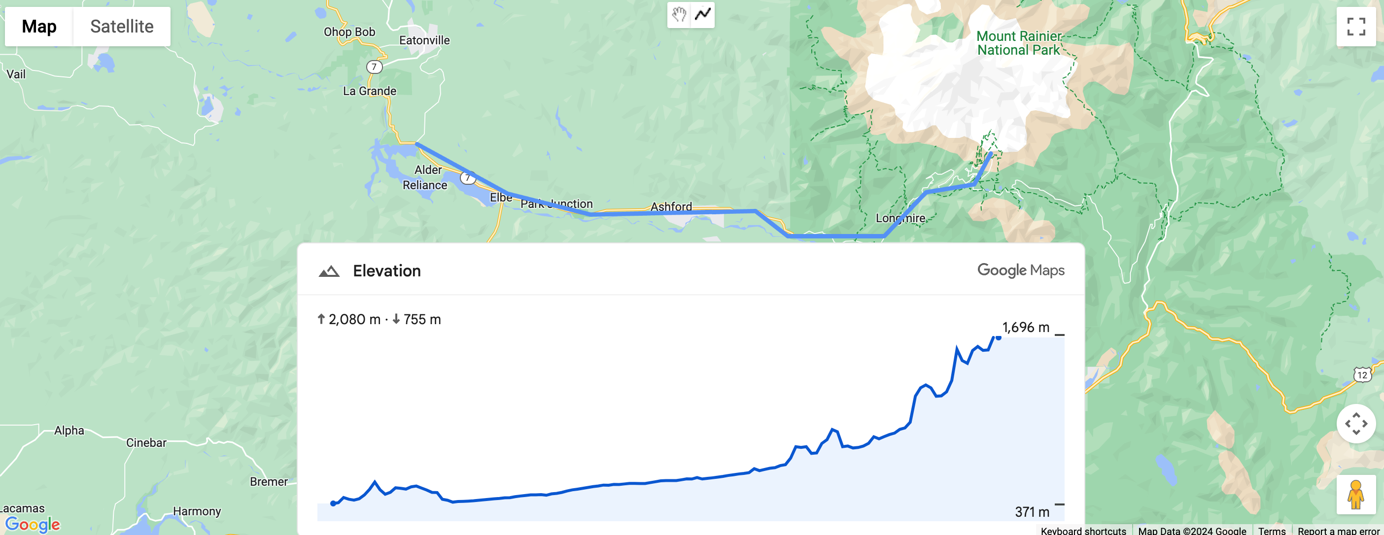
Ustawianie wysokości ścieżki za pomocą współrzędnych
W tym przykładzie renderujemy wysokość ścieżki między 2 punktami wybranymi za pomocą zestawu współrzędnych za pomocą elementu gmp-elevation
.
Element jest skonfigurowany do pomiaru danych za pomocą atrybutu
unit-system
:
<gmp-elevation unit-system="metric"></gmp-elevation>
Element querySelector
służy do wybierania elementu wysokości i ustawiania jego właściwości path
za pomocą współrzędnych szerokości i długości geograficznej:
/** Maps JS loaded callback */
async function init() {
// Load the Elevation Element from Maps JS
const {ElevationElement} = await google.maps.importLibrary('elevation');
// Specify an elevation path to render
const elevationElement = document.querySelector('gmp-elevation');
elevationElement.path = [
{lat: 37.4523, lng: -122.2645},
{lat: 37.377, lng: -122.4078},
];
}
Pełny przykład kodu
JavaScript
/** Maps JS loaded callback */
async function init() {
// Load the Elevation Element from Maps JS
const {ElevationElement} = await google.maps.importLibrary('elevation');
// Specify an elevation path to render
const elevationElement = document.querySelector('gmp-elevation');
elevationElement.path = [
{lat: 37.4523, lng: -122.2645},
{lat: 37.377, lng: -122.4078},
];
}
init();
CSS
html, body {
margin: 0;
padding: 0;
}
gmp-elevation {
width: 100%;
height: 100%;
}
.overlay {
margin: 20px;
width: 400px;
}
HTML
<!DOCTYPE html>
<html>
<head>
<title>Simple Elevation</title>
<meta charset="utf-8">
<link rel="stylesheet" type="text/css" href="style.css">
</head>
<body>
<h1>Path elevation</h1>
<div class="overlay">
<gmp-elevation unit-system="metric"></gmp-elevation>
</div>
<script>
(g=>{var h,a,k,p="The Google Maps JavaScript API",c="google",l="importLibrary",q="__ib__",m=document,b=window;b=b[c]||(b[c]={});var d=b.maps||(b.maps={}),r=new Set,e=new URLSearchParams,u=()=>h||(h=new Promise(async(f,n)=>{await (a=m.createElement("script"));e.set("libraries",[...r]+"");for(k in g)e.set(k.replace(/[A-Z]/g,t=>"_"+t[0].toLowerCase()),g[k]);e.set("callback",c+".maps."+q);a.src=`https://maps.${c}apis.com/maps/api/js?`+e;d[q]=f;a.onerror=()=>h=n(Error(p+" could not load."));a.nonce=m.querySelector("script[nonce]")?.nonce||"";m.head.append(a)}));d[l]?console.warn(p+" only loads once. Ignoring:",g):d[l]=(f,...n)=>r.add(f)&&u().then(()=>d[l](f,...n))})({
key: "YOUR_API_KEY",
v: "alpha"
});
</script>
</body>
</html>
Ustawianie wzniesienia ścieżki za pomocą linii łamanej
W tym przykładzie wygładza on ścieżkę na podstawie rysowanej przez użytkownika wielolinii. Uzyskiwanie wartości
path
z polilinii użytkownika za pomocą funkcji polyline.getPath().getArray()
:
elevationElem.path = polyline.getPath().getArray();
Pełny przykład kodu
JavaScript
const map = document.querySelector('gmp-map');
const elevationElem = document.querySelector('gmp-elevation');
async function init() {
await google.maps.importLibrary('places');
await google.maps.importLibrary('marker');
await google.maps.importLibrary('elevation');
map.innerMap.setOptions({'mapTypeControl': true, 'clickableIcons': false});
findCurrentLocation();
drawPolyline();
}
async function drawPolyline() {
const {DrawingManager} = await google.maps.importLibrary('drawing');
const drawingManager = new DrawingManager({
drawingMode: google.maps.drawing.OverlayType.POLYLINE,
drawingControl: true,
drawingControlOptions: {
position: google.maps.ControlPosition.TOP_CENTER,
drawingModes: [google.maps.drawing.OverlayType.POLYLINE]
},
polylineOptions: {geodesic: true, strokeColor: '#5491f5', strokeWeight: 6}
});
drawingManager.setMap(map.innerMap);
drawingManager.addListener('polylinecomplete', (polyline) => {
console.log('complete');
console.log(polyline.getPath().getArray());
elevationElem.path = polyline.getPath().getArray();
polyline.addListener('click', (e) => {
console.log(e);
});
});
}
async function findCurrentLocation() {
const {LatLng} = await google.maps.importLibrary('core');
if (navigator.geolocation) {
navigator.geolocation.getCurrentPosition(
(position) => {
const pos =
new LatLng(position.coords.latitude, position.coords.longitude);
map.innerMap.panTo(pos);
map.innerMap.setZoom(16);
},
() => {
console.log('The Geolocation service failed.');
map.innerMap.setZoom(16);
},
);
} else {
console.log(`Your browser doesn't support geolocation`);
map.innerMap.setZoom(16);
}
}
init();
CSS
html, body {
height: 100%;
margin: 0;
}
body {
display: flex;
flex-direction: column;
font-family: Arial, Helvetica, sans-serif;
}
h1 {
font-size: 16px;
text-align: center;
}
gmp-map {
box-sizing: border-box;
margin-top: 20px;
width: 100%;
height: 100%;
}
gmp-elevation {
width: 100%;
height: 300px;
}
.overlay {
width: 800px;
}
HTML
<!DOCTYPE html>
<html>
<head>
<title>Path Elevation</title>
<meta charset="utf-8">
<link rel="stylesheet" type="text/css" href="style.css">
</head>
<body>
<h1>Draw polyline and get path elevation</h1>
<gmp-map center="-37.813,144.963" zoom="12" map-id="DEMO_MAP_ID">
<div id="elevation-container" class="overlay" slot="control-block-end-inline-center">
<gmp-elevation unit-system="metric"></gmp-elevation>
</div>
</gmp-map>
<script>
(g=>{var h,a,k,p="The Google Maps JavaScript API",c="google",l="importLibrary",q="__ib__",m=document,b=window;b=b[c]||(b[c]={});var d=b.maps||(b.maps={}),r=new Set,e=new URLSearchParams,u=()=>h||(h=new Promise(async(f,n)=>{await (a=m.createElement("script"));e.set("libraries",[...r]+"");for(k in g)e.set(k.replace(/[A-Z]/g,t=>"_"+t[0].toLowerCase()),g[k]);e.set("callback",c+".maps."+q);a.src=`https://maps.${c}apis.com/maps/api/js?`+e;d[q]=f;a.onerror=()=>h=n(Error(p+" could not load."));a.nonce=m.querySelector("script[nonce]")?.nonce||"";m.head.append(a)}));d[l]?console.warn(p+" only loads once. Ignoring:",g):d[l]=(f,...n)=>r.add(f)&&u().then(()=>d[l](f,...n))})({
key: "YOUR_API_KEY",
v: "alpha"
});
</script>
</body>
</html>
O ile nie stwierdzono inaczej, treść tej strony jest objęta licencją Creative Commons – uznanie autorstwa 4.0, a fragmenty kodu są dostępne na licencji Apache 2.0. Szczegółowe informacje na ten temat zawierają zasady dotyczące witryny Google Developers. Java jest zastrzeżonym znakiem towarowym firmy Oracle i jej podmiotów stowarzyszonych.
Ostatnia aktualizacja: 2025-06-05 UTC.
[null,null,["Ostatnia aktualizacja: 2025-06-05 UTC."],[[["\u003cp\u003eThe \u003ccode\u003eElevationElement\u003c/code\u003e displays elevation data for a point or polyline on a map using a graph.\u003c/p\u003e\n"],["\u003cp\u003eYou can set the elevation path using latitude and longitude coordinates or with a user-drawn polyline.\u003c/p\u003e\n"],["\u003cp\u003eThe elevation graph is generated by interpolating line segments between the provided coordinates.\u003c/p\u003e\n"],["\u003cp\u003eThis feature is currently experimental and might have limited support.\u003c/p\u003e\n"]]],["The `ElevationElement` visually displays elevation data for a point or polyline. It uses a `gmp-elevation` element configured for metric measurements. Elevation paths can be set via coordinates or a user-drawn polyline. When using coordinates, a `querySelector` selects the element, and the `path` property is set with latitude/longitude arrays. For polylines, the element's `path` is populated using `polyline.getPath().getArray()`, to get an array of the polyline's coordinates. This feature is currently in an experimental pre-GA stage.\n"],null,["| This product or feature is Experimental (pre-GA). Pre-GA products and features might have limited support, and changes to pre-GA products and features might not be compatible with other pre-GA versions. Pre-GA Offerings are covered by the [Google\n| Maps Platform Service Specific Terms](https://cloud.google.com/maps-platform/terms/maps-service-terms). For more information, see the [launch stage descriptions](/maps/launch-stages).\nElevation Standalone Element\n\nThe [`ElevationElement`](/maps/documentation/javascript/reference/elevation-widget#ElevationElement) is an HTML element that visually displays elevation data for a single point or a polyline. It shows a graph of elevation along the path set in the [`path`](/maps/documentation/javascript/reference/elevation-widget#ElevationElement.path) property with an array of latitude and longitude coordinates. Line segments are interpolated between the points of the array, so even a small number of points will still produce a detailed elevation graph.\n\nSet path elevation using coordinates\n\nThe following example renders the elevation of a path between two points selected by a set of coordinates, using a `gmp-elevation` element.\n\nThe element is configured for metric measurement using the [`unit-system`](/maps/documentation/javascript/reference/elevation-widget#ElevationElement.unitSystem) attribute: \n\n```html\n \u003cgmp-elevation unit-system=\"metric\"\u003e\u003c/gmp-elevation\u003e\n```\n\nA `querySelector` is used to select the elevation element and set its `path` property with latitude and longitude coordinates: \n\n```javascript\n/** Maps JS loaded callback */\nasync function init() {\n // Load the Elevation Element from Maps JS\n const {ElevationElement} = await google.maps.importLibrary('elevation');\n\n // Specify an elevation path to render\n const elevationElement = document.querySelector('gmp-elevation');\n elevationElement.path = [\n {lat: 37.4523, lng: -122.2645},\n {lat: 37.377, lng: -122.4078},\n ];\n}\n```\n\nSee the complete code example \n\nJavaScript \n\n```javascript\n/** Maps JS loaded callback */\nasync function init() {\n // Load the Elevation Element from Maps JS\n const {ElevationElement} = await google.maps.importLibrary('elevation');\n\n // Specify an elevation path to render\n const elevationElement = document.querySelector('gmp-elevation');\n elevationElement.path = [\n {lat: 37.4523, lng: -122.2645},\n {lat: 37.377, lng: -122.4078},\n ];\n}\n\ninit();\n```\n\nCSS \n\n```css\nhtml, body {\n margin: 0;\n padding: 0;\n}\n\ngmp-elevation {\n width: 100%;\n height: 100%;\n}\n\n.overlay {\n margin: 20px;\n width: 400px;\n}\n```\n\nHTML \n\n```html\n\u003c!DOCTYPE html\u003e\n\u003chtml\u003e\n \u003chead\u003e\n \u003ctitle\u003eSimple Elevation\u003c/title\u003e\n \u003cmeta charset=\"utf-8\"\u003e\n \u003clink rel=\"stylesheet\" type=\"text/css\" href=\"style.css\"\u003e\n \u003c/head\u003e\n \u003cbody\u003e\n \u003ch1\u003ePath elevation\u003c/h1\u003e\n \u003cdiv class=\"overlay\"\u003e\n \u003cgmp-elevation unit-system=\"metric\"\u003e\u003c/gmp-elevation\u003e\n \u003c/div\u003e\n \u003cscript\u003e\n (g=\u003e{var h,a,k,p=\"The Google Maps JavaScript API\",c=\"google\",l=\"importLibrary\",q=\"__ib__\",m=document,b=window;b=b[c]||(b[c]={});var d=b.maps||(b.maps={}),r=new Set,e=new URLSearchParams,u=()=\u003eh||(h=new Promise(async(f,n)=\u003e{await (a=m.createElement(\"script\"));e.set(\"libraries\",[...r]+\"\");for(k in g)e.set(k.replace(/[A-Z]/g,t=\u003e\"_\"+t[0].toLowerCase()),g[k]);e.set(\"callback\",c+\".maps.\"+q);a.src=`https://maps.${c}apis.com/maps/api/js?`+e;d[q]=f;a.onerror=()=\u003eh=n(Error(p+\" could not load.\"));a.nonce=m.querySelector(\"script[nonce]\")?.nonce||\"\";m.head.append(a)}));d[l]?console.warn(p+\" only loads once. Ignoring:\",g):d[l]=(f,...n)=\u003er.add(f)&&u().then(()=\u003ed[l](f,...n))})({\n key: \"YOUR_API_KEY\",\n v: \"alpha\"\n });\n \u003c/script\u003e\n \u003c/body\u003e\n\u003c/html\u003e\n```\n\nSet path elevation using a polyline\n\nThe following example renders the elevation of a path based on a user-drawn polyline. It obtains the [`path`](/maps/documentation/javascript/reference/elevation-widget#ElevationElement.path) from the user's polyline using [`polyline.getPath().getArray()`:](/maps/documentation/javascript/reference/polygon#Polyline.getPath) \n\n```javascript\n elevationElem.path = polyline.getPath().getArray();\n```\n\nSee the complete code example \n\nJavaScript \n\n```javascript\nconst map = document.querySelector('gmp-map');\nconst elevationElem = document.querySelector('gmp-elevation');\n\nasync function init() {\n await google.maps.importLibrary('places');\n await google.maps.importLibrary('marker');\n await google.maps.importLibrary('elevation');\n\n\n map.innerMap.setOptions({'mapTypeControl': true, 'clickableIcons': false});\n\n findCurrentLocation();\n drawPolyline();\n}\n\nasync function drawPolyline() {\n const {DrawingManager} = await google.maps.importLibrary('drawing');\n const drawingManager = new DrawingManager({\n drawingMode: google.maps.drawing.OverlayType.POLYLINE,\n drawingControl: true,\n drawingControlOptions: {\n position: google.maps.ControlPosition.TOP_CENTER,\n drawingModes: [google.maps.drawing.OverlayType.POLYLINE]\n },\n polylineOptions: {geodesic: true, strokeColor: '#5491f5', strokeWeight: 6}\n });\n\n drawingManager.setMap(map.innerMap);\n\n drawingManager.addListener('polylinecomplete', (polyline) =\u003e {\n console.log('complete');\n console.log(polyline.getPath().getArray());\n elevationElem.path = polyline.getPath().getArray();\n polyline.addListener('click', (e) =\u003e {\n console.log(e);\n });\n });\n}\n\nasync function findCurrentLocation() {\n const {LatLng} = await google.maps.importLibrary('core');\n if (navigator.geolocation) {\n navigator.geolocation.getCurrentPosition(\n (position) =\u003e {\n const pos =\n new LatLng(position.coords.latitude, position.coords.longitude);\n map.innerMap.panTo(pos);\n map.innerMap.setZoom(16);\n },\n () =\u003e {\n console.log('The Geolocation service failed.');\n map.innerMap.setZoom(16);\n },\n );\n } else {\n console.log(`Your browser doesn't support geolocation`);\n map.innerMap.setZoom(16);\n }\n}\n\ninit();\n```\n\nCSS \n\n```css\nhtml, body {\n height: 100%;\n margin: 0;\n}\n\nbody {\n display: flex;\n flex-direction: column;\n font-family: Arial, Helvetica, sans-serif;\n}\n\nh1 {\n font-size: 16px;\n text-align: center;\n}\n\ngmp-map {\n box-sizing: border-box;\n margin-top: 20px;\n width: 100%;\n height: 100%;\n}\n\ngmp-elevation {\n width: 100%;\n height: 300px;\n}\n\n.overlay {\n width: 800px;\n}\n```\n\nHTML \n\n```html\n\u003c!DOCTYPE html\u003e\n\u003chtml\u003e\n \u003chead\u003e\n \u003ctitle\u003ePath Elevation\u003c/title\u003e\n \u003cmeta charset=\"utf-8\"\u003e\n \u003clink rel=\"stylesheet\" type=\"text/css\" href=\"style.css\"\u003e\n \u003c/head\u003e\n \u003cbody\u003e\n \u003ch1\u003eDraw polyline and get path elevation\u003c/h1\u003e\n \u003cgmp-map center=\"-37.813,144.963\" zoom=\"12\" map-id=\"DEMO_MAP_ID\"\u003e\n \u003cdiv id=\"elevation-container\" class=\"overlay\" slot=\"control-block-end-inline-center\"\u003e\n \u003cgmp-elevation unit-system=\"metric\"\u003e\u003c/gmp-elevation\u003e\n \u003c/div\u003e\n \u003c/gmp-map\u003e\n \u003cscript\u003e\n (g=\u003e{var h,a,k,p=\"The Google Maps JavaScript API\",c=\"google\",l=\"importLibrary\",q=\"__ib__\",m=document,b=window;b=b[c]||(b[c]={});var d=b.maps||(b.maps={}),r=new Set,e=new URLSearchParams,u=()=\u003eh||(h=new Promise(async(f,n)=\u003e{await (a=m.createElement(\"script\"));e.set(\"libraries\",[...r]+\"\");for(k in g)e.set(k.replace(/[A-Z]/g,t=\u003e\"_\"+t[0].toLowerCase()),g[k]);e.set(\"callback\",c+\".maps.\"+q);a.src=`https://maps.${c}apis.com/maps/api/js?`+e;d[q]=f;a.onerror=()=\u003eh=n(Error(p+\" could not load.\"));a.nonce=m.querySelector(\"script[nonce]\")?.nonce||\"\";m.head.append(a)}));d[l]?console.warn(p+\" only loads once. Ignoring:\",g):d[l]=(f,...n)=\u003er.add(f)&&u().then(()=\u003ed[l](f,...n))})({\n key: \"YOUR_API_KEY\",\n v: \"alpha\"\n });\n \u003c/script\u003e\n \u003c/body\u003e\n\u003c/html\u003e\n```"]]