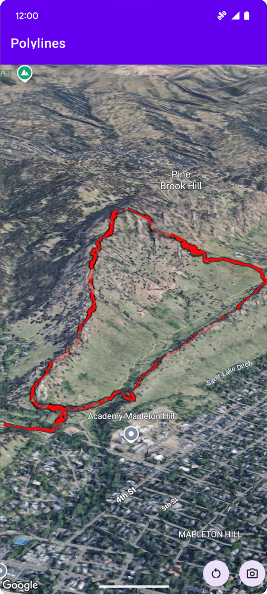
The following code sample
demonstrates how to add a polyline and position it in 3D space by calling the
addPolyline
method. To use this code sample, follow the instructions in
Setup and
Add a 3D map to your app to set
up your Android Studio project with a basic 3D map. Then, add the following code to the
MainActivity.kt file:
// Add importsimportcom.google.android.gms.maps3d.model.latLngAltitude...// Add to the onMap3DViewReady method, after the googleMap3D object has been initializedgoogleMap3D.setCamera(camera{center=latLngAltitude{latitude=40.029349longitude=-105.300354altitude=1833.9}heading=326.0tilt=75.0range=3757.0})internalvaltrailLocations=""" 40.0201040, -105.2976640 40.0201080, -105.2976450 40.0201640, -105.2975120 40.0202200, -105.2973740 40.0202500, -105.2972760 40.0202960, -105.2971410 40.0203080, -105.2970990 40.0203320, -105.2970070 40.0203640, -105.2969400 40.0203710, -105.2969250 40.0203770, -105.2969220 40.0203910, -105.2969130 40.0203940, -105.2969120 40.0204200, -105.2969130 40.0204630, -105.2968910 40.0205270, -105.2968280 40.0206030, -105.2967570 40.0206590, -105.2966100 40.0206990, -105.2964870""".trimIndent().split("\n").map{val(lat,lng)=it.split(",")latLngAltitude{latitude=lat.toDouble()longitude=lng.toDouble()altitude=0.0// The trail will be clamped to the ground}}valtrailPolylineOptions=polylineOptions{coordinates=trailLocationsstrokeColor=Color.REDstrokeWidth=7.0altitudeMode=AltitudeMode.CLAMP_TO_GROUNDzIndex=5drawsOccludedSegments=true}googleMap3D.addPolyline(trailPolylineOptions)
[null,null,["Last updated 2025-08-28 UTC."],[],[],null,["# Add a polyline to a map\n\nSelect platform: [Android](/maps/documentation/maps-3d/android-sdk/add-polylines \"View this page for the Android platform docs.\") [iOS](/maps/documentation/maps-3d/ios-sdk/add-polylines \"View this page for the iOS platform docs.\") [JavaScript](/maps/documentation/javascript/3d/shapes-lines \"View this page for the JavaScript platform docs.\")\n\n\u003cbr /\u003e\n\n| This product or feature is Experimental (pre-GA). Pre-GA products and features might have limited support, and changes to pre-GA products and features might not be compatible with other pre-GA versions. Pre-GA Offerings are covered by the [Google\n| Maps Platform Service Specific Terms](https://cloud.google.com/maps-platform/terms/maps-service-terms). For more information, see the [launch stage descriptions](/maps/launch-stages).\n\n\nThe following code sample\ndemonstrates how to add a polyline and position it in 3D space by calling the\n[`addPolyline`](/maps/documentation/maps-3d/android-sdk/reference/com/google/android/gms/maps3d/GoogleMap3D#addPolyline(com.google.android.gms.maps3d.model.PolylineOptions))\nmethod. To use this code sample, follow the instructions in\n[Setup](/maps/documentation/maps-3d/android-sdk/setup) and\n[Add a 3D map to your app](/maps/documentation/maps-3d/android-sdk/add-a-3d-map) to set\nup your Android Studio project with a basic 3D map. Then, add the following code to the\n**`MainActivity.kt`** file: \n\n```kotlin\n// Add imports\nimport com.google.android.gms.maps3d.model.latLngAltitude\n\n...\n\n// Add to the onMap3DViewReady method, after the googleMap3D object has been initialized\ngoogleMap3D.setCamera(\n camera {\n center = latLngAltitude {\n latitude = 40.029349\n longitude = -105.300354\n altitude = 1833.9\n }\n heading = 326.0\n tilt = 75.0\n range = 3757.0\n }\n)\ninternal val trailLocations = \"\"\"\n 40.0201040, -105.2976640\n 40.0201080, -105.2976450\n 40.0201640, -105.2975120\n 40.0202200, -105.2973740\n 40.0202500, -105.2972760\n 40.0202960, -105.2971410\n 40.0203080, -105.2970990\n 40.0203320, -105.2970070\n 40.0203640, -105.2969400\n 40.0203710, -105.2969250\n 40.0203770, -105.2969220\n 40.0203910, -105.2969130\n 40.0203940, -105.2969120\n 40.0204200, -105.2969130\n 40.0204630, -105.2968910\n 40.0205270, -105.2968280\n 40.0206030, -105.2967570\n 40.0206590, -105.2966100\n 40.0206990, -105.2964870\n\"\"\".trimIndent().split(\"\\n\").map {\n val (lat, lng) = it.split(\",\")\n latLngAltitude {\n latitude = lat.toDouble()\n longitude = lng.toDouble()\n altitude = 0.0 // The trail will be clamped to the ground\n }\n}\n\nval trailPolylineOptions = polylineOptions {\n coordinates = trailLocations\n strokeColor = Color.RED\n strokeWidth = 7.0\n altitudeMode = AltitudeMode.CLAMP_TO_GROUND\n zIndex = 5\n drawsOccludedSegments = true\n}\n\ngoogleMap3D.addPolyline(trailPolylineOptions)\n```"]]