配置标记的海拔高度
使用集合让一切井井有条
根据您的偏好保存内容并对其进行分类。
您可以通过将标记的 altitudeMode
属性设置为以下某个值来设置标记的海拔高度:
ABSOLUTE
RELATIVE_TO_GROUND
CLAMP_TO_GROUND
RELATIVE_TO_MESH
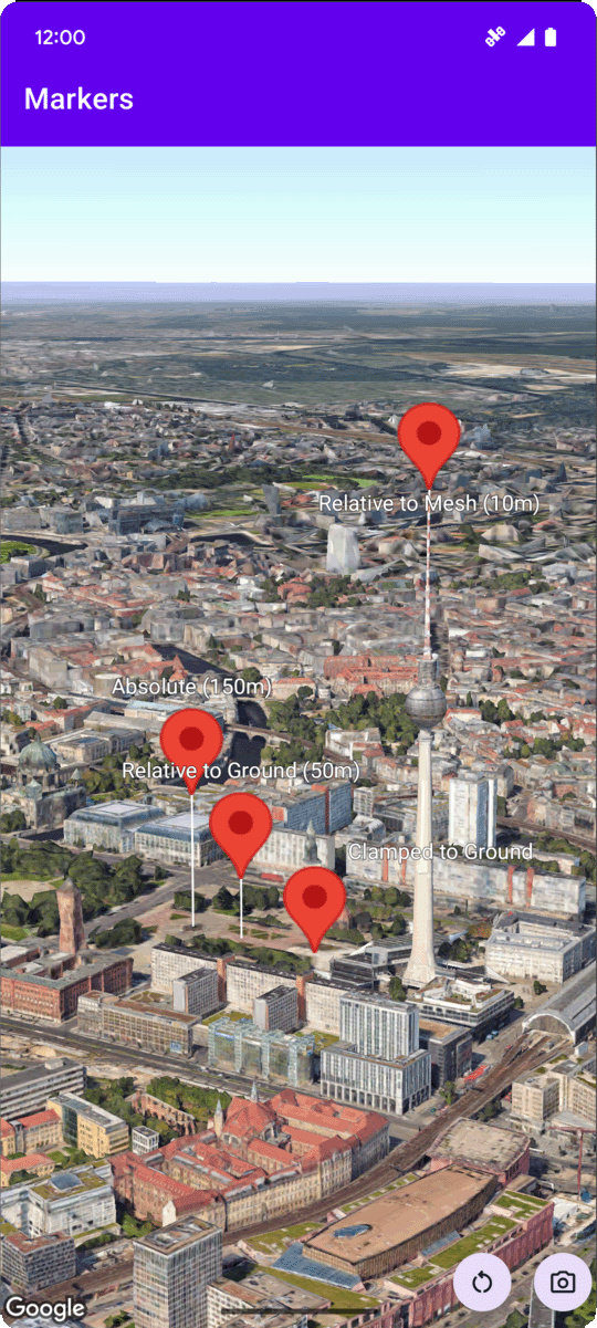
以下代码示例演示了如何使用每种方法。如需使用此代码示例,请按照设置和向应用添加 3D 地图中的说明,在 Android Studio 项目中设置基本 3D 地图。然后,将以下代码添加到 MainActivity.kt
文件中:
// Add imports
import com.google.android.gms.maps3d.model.latLngAltitude
...
// Add to the onMap3DViewReady method, after the googleMap3D object has been initialized
googleMap3D.setMapMode(Map3DMode.SATELLITE)
googleMap3D.setCamera(
camera {
center = latLngAltitude {
latitude = 52.51974795
longitude = 13.40715553
altitude = 150.0
}
heading = 252.7
tilt = 79.0
range = 1500.0
}
)
// Marker 1: Absolute
googleMap3D.addMarker(markerOptions {
position = latLngAltitude {
latitude = 52.519605780912585
longitude = 13.406867190588198
altitude = 150.0
}
label = "Absolute (150m)"
altitudeMode = AltitudeMode.ABSOLUTE
isExtruded = true
isDrawnWhenOccluded = true
collisionBehavior = CollisionBehavior.REQUIRED_AND_HIDES_OPTIONAL
})
// Marker 2: Relative to Ground
googleMap3D.addMarker(markerOptions {
position = latLngAltitude {
latitude = 52.519882191069016
longitude = 13.407410777254293
altitude = 50.0
}
label = "Relative to Ground (50m)"
altitudeMode = AltitudeMode.RELATIVE_TO_GROUND
isExtruded = true
isDrawnWhenOccluded = true
})
// Marker 3: Clamped to Ground
googleMap3D.addMarker(markerOptions {
position = latLngAltitude {
latitude = 52.52027645136134
longitude = 13.408271658592406
altitude = 0.0 // altitude is effectively ignored by CLAMP_TO_GROUND for rendering,
// but might be relevant if you read the marker's position later.
// For CLAMP_TO_GROUND, it's often set to 0.0.
}
label = "Clamped to Ground"
altitudeMode = AltitudeMode.CLAMP_TO_GROUND
isExtruded = true
isDrawnWhenOccluded = true
})
// Marker 4: Relative to Mesh
googleMap3D.addMarker(markerOptions {
position = latLngAltitude {
latitude = 52.520835071144226
longitude = 13.409426847943774
altitude = 10.0 // Altitude relative to 3D mesh (buildings, terrain features)
}
label = "Relative to Mesh (10m)"
altitudeMode = AltitudeMode.RELATIVE_TO_MESH
isExtruded = true
isDrawnWhenOccluded = true
})
如未另行说明,那么本页面中的内容已根据知识共享署名 4.0 许可获得了许可,并且代码示例已根据 Apache 2.0 许可获得了许可。有关详情,请参阅 Google 开发者网站政策。Java 是 Oracle 和/或其关联公司的注册商标。
最后更新时间 (UTC):2025-08-31。
[null,null,["最后更新时间 (UTC):2025-08-31。"],[],[],null,["# Configure marker altitude\n\nSelect platform: [Android](/maps/documentation/maps-3d/android-sdk/configure-marker-altitude \"View this page for the Android platform docs.\") [iOS](/maps/documentation/maps-3d/ios-sdk/configure-marker-altitude \"View this page for the iOS platform docs.\")\n\n\u003cbr /\u003e\n\n| This product or feature is Experimental (pre-GA). Pre-GA products and features might have limited support, and changes to pre-GA products and features might not be compatible with other pre-GA versions. Pre-GA Offerings are covered by the [Google\n| Maps Platform Service Specific Terms](https://cloud.google.com/maps-platform/terms/maps-service-terms). For more information, see the [launch stage descriptions](/maps/launch-stages).\n\n\nYou can set a marker's altitude by setting the\n[`altitudeMode`](/maps/documentation/maps-3d/android-sdk/reference/com/google/android/gms/maps3d/model/MarkerOptions#altitudeMode())\nproperty to one of the\nfollowing values:\n\n- `ABSOLUTE`\n- `RELATIVE_TO_GROUND`\n- `CLAMP_TO_GROUND`\n- `RELATIVE_TO_MESH`\n\nThe following code sample\ndemonstrates how to use each of the methods. To use this code sample, follow the instructions in\n[Setup](/maps/documentation/maps-3d/android-sdk/setup) and\n[Add a 3D map to your app](/maps/documentation/maps-3d/android-sdk/add-a-3d-map) to set\nup your Android Studio project with a basic 3D map. Then, add the following code to the\n**`MainActivity.kt`** file: \n\n```kotlin\n // Add imports\n import com.google.android.gms.maps3d.model.latLngAltitude\n \n ...\n \n // Add to the onMap3DViewReady method, after the googleMap3D object has been initialized\n googleMap3D.setMapMode(Map3DMode.SATELLITE)\n \n googleMap3D.setCamera(\n camera {\n center = latLngAltitude {\n latitude = 52.51974795\n longitude = 13.40715553\n altitude = 150.0\n }\n heading = 252.7\n tilt = 79.0\n range = 1500.0\n }\n )\n \n \n // Marker 1: Absolute\n googleMap3D.addMarker(markerOptions {\n position = latLngAltitude {\n latitude = 52.519605780912585\n longitude = 13.406867190588198\n altitude = 150.0\n }\n label = \"Absolute (150m)\"\n altitudeMode = AltitudeMode.ABSOLUTE\n isExtruded = true\n isDrawnWhenOccluded = true\n collisionBehavior = CollisionBehavior.REQUIRED_AND_HIDES_OPTIONAL\n })\n \n // Marker 2: Relative to Ground\n googleMap3D.addMarker(markerOptions {\n position = latLngAltitude {\n latitude = 52.519882191069016\n longitude = 13.407410777254293\n altitude = 50.0\n }\n label = \"Relative to Ground (50m)\"\n altitudeMode = AltitudeMode.RELATIVE_TO_GROUND\n isExtruded = true\n isDrawnWhenOccluded = true\n })\n \n // Marker 3: Clamped to Ground\n googleMap3D.addMarker(markerOptions {\n position = latLngAltitude {\n latitude = 52.52027645136134\n longitude = 13.408271658592406\n altitude = 0.0 // altitude is effectively ignored by CLAMP_TO_GROUND for rendering,\n // but might be relevant if you read the marker's position later.\n // For CLAMP_TO_GROUND, it's often set to 0.0.\n }\n label = \"Clamped to Ground\"\n altitudeMode = AltitudeMode.CLAMP_TO_GROUND\n isExtruded = true\n isDrawnWhenOccluded = true\n })\n \n // Marker 4: Relative to Mesh\n googleMap3D.addMarker(markerOptions {\n position = latLngAltitude {\n latitude = 52.520835071144226\n longitude = 13.409426847943774\n altitude = 10.0 // Altitude relative to 3D mesh (buildings, terrain features)\n }\n label = \"Relative to Mesh (10m)\"\n altitudeMode = AltitudeMode.RELATIVE_TO_MESH\n isExtruded = true\n isDrawnWhenOccluded = true\n })\n \n \n```"]]