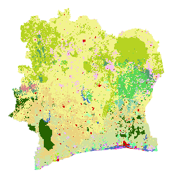
La carte de couverture du sol de la Côte d'Ivoire BNETD 2020 a été produite par le gouvernement ivoirien par le biais d'une institution nationale, le Centre d'information géographique et numérique de l'Office national d'études techniques et de développement (BNETD-CIGN), avec le soutien technique et financier de l'Union européenne. La méthodologie utilisée pour produire la carte était transparente, participative et conforme aux normes internationales.
Pour développer cette carte, une mosaïque d'images satellite (Sentinel 2) de 2020 a été traitée via Google Earth Engine et complétée par des données collectées sur le terrain, afin d'entraîner un algorithme de classification supervisée (Random Forest).
Deux campagnes sur le terrain ont été menées dans tout le pays, du 10 novembre au 9 décembre 2022 et du 26 janvier au 13 février 2023. Ces missions ont impliqué 33 personnes de plusieurs organisations partenaires, car les méthodes de collecte de données et les définitions de certaines classes d'utilisation des terres adoptées par les parties prenantes peuvent parfois différer.
Dans le cadre de la procédure de diligence raisonnable de l'EUDR, les données de géolocalisation des parcelles de terrain produisant des produits concernés par l'EUDR pourraient être superposées aux données de couverture forestière de 2020 afin d'évaluer le risque que la parcelle soit située dans une zone boisée avant la date limite de 2020. Pour ce faire, vous devez disposer de données sur le couvert forestier qui correspondent à la définition des forêts de la FAO et à la date limite de 2020. La carte de couverture terrestre de la Côte d'Ivoire en 2020 répond à ces besoins.
En effet, les classes de la carte de couverture terrestre peuvent être combinées pour créer une carte forêt/non-forêt qui correspond à la définition des forêts de la FAO.
Une plate-forme permettant d'accéder aux données, aux métadonnées et à la méthodologie de couverture des sols de 2020 a été développée à l'aide des solutions ESRI, à partir d'Africa GeoPortal, pour l'analyse et la visualisation des données :
La carte de couverture des sols BNETD 2020 de la Côte d'Ivoire a été produite par le gouvernement ivoirien par le biais d'une institution nationale, le Centre d'information géographique et numérique du Bureau national d'études techniques et de développement (BNETD-CIGN), avec le soutien technique et financier de l'Union européenne. La méthodologie utilisée pour produire la carte …
[null,null,[],[[["\u003cp\u003eThe Cote d'Ivoire BNETD 2020 Land Cover Map provides a detailed classification of land cover across Cote d'Ivoire for the year 2020, created using Sentinel 2 satellite imagery and ground-truthed data.\u003c/p\u003e\n"],["\u003cp\u003eThis dataset, produced by the Ivorian Government with support from the European Union, follows international standards and offers 10-meter resolution for analysis.\u003c/p\u003e\n"],["\u003cp\u003eUsers can access the dataset through Google Earth Engine and the Africa GeoPortal for visualization and analysis, with the possibility of overlaying it with other data for due diligence purposes like assessing deforestation risk.\u003c/p\u003e\n"],["\u003cp\u003eThe land cover classifications include a variety of forest types, plantations, agricultural areas, water bodies, and human infrastructure, allowing for comprehensive land use assessments.\u003c/p\u003e\n"],["\u003cp\u003eThe dataset is available under a CC-BY-4.0 license, encouraging open access and use for research, education, and non-profit purposes.\u003c/p\u003e\n"]]],[],null,["# Cote d'Ivoire BNETD 2020 Land Cover Map\n\nDataset Availability\n: 2020-01-01T00:00:00Z--2021-01-01T00:00:00Z\n\nDataset Provider\n:\n\n\n [BNETD-CIGN](https://africageoportal.maps.arcgis.com/home/user.html?user=bnetdcignCI)\n\nCadence\n: 1 Year\n\nTags\n:\n[classification](/earth-engine/datasets/tags/classification) [deforestation](/earth-engine/datasets/tags/deforestation) [forest](/earth-engine/datasets/tags/forest) [landcover](/earth-engine/datasets/tags/landcover) [landuse-landcover](/earth-engine/datasets/tags/landuse-landcover) \n\n#### Description\n\nThe Cote d'Ivoire BNETD 2020 Land Cover Map was produced by the Ivorian\nGovernment through a national institution, the Center for Geographic\nInformation and Digital from the National Study Office Techniques and\nDevelopment (BNETD-CIGN), with technical and financial support from the\nEuropean Union. The methodology used to produce the map was transparent,\nparticipatory and in line with international standards.\n\nTo develop this map, a mosaic of satellite images (Sentinel 2) from 2020 was\nprocessed via Google Earth Engine and supplemented with data collected in the\nfield, to train a supervised classification algorithm (Random Forest).\nTwo field campaigns were conducted, from 10 November to 9 December 2022 and\nfrom 26 January to 13 February 2023, throughout the country. These missions\ninvolved 33 people from multiple partner organizations because the data\ncollection methods and definitions of certain land use classes\nadopted by stakeholders may sometimes differ.\n\nAs part of the EUDR due diligence process, geolocation data for plots of\nland producing EUDR-relevant products could be overlaid with 2020 forest\ncover data in order to assess the risk that the plot is located in an area\nthat was forested before the 2020 cut-off date. To do this, forest cover\ndata aligned with the FAO definition of forests and the 2020 cut-off date\nis required. The 2020 land cover map of Cote d'Ivoire meets these needs.\nIndeed, the classes in the land cover map can be combined to create a\nforest/non-forest map that is aligned with the FAO definition of forests.\n\nA platform for accessing 2020 land cover data, metadata and the methodology\nhas been developed using ESRI solutions, from Africa GeoPortal, for data\nanalysis and visualization:\n\nThe address is: \u003chttps://bit.ly/carte-ci-2020\u003e\n\nDocumentation:\n\n- [Detailed documentation](https://africageoportal.maps.arcgis.com/sharing/rest/content/items/26a717d4c13f4f3db2c6056f7e5c0bab/data)\n\n- [Methodology in French](https://africageoportal.maps.arcgis.com/sharing/rest/content/items/76dc18767b89472eb89e8aa54e08a6c9/data)\n\n### Bands\n\n\n**Pixel Size**\n\n10 meters\n\n**Bands**\n\n| Name | Min | Max | Pixel Size | Description |\n|------------------|-----|-----|------------|------------------|\n| `classification` | 1 | 23 | meters | Land Cover class |\n\n**classification Class Table**\n\n| Value | Color | Description |\n|-------|---------|-------------------------------------------------------------------------------------------------------------------|\n| 1 | #276300 | Dense forest (Forêt dense) |\n| 2 | #59D757 | Light forest (Forêt claire) |\n| 3 | #569D6E | Forest gallery (Forêt galerie) |\n| 4 | #79CFAD | Secondary forest/degraded forest (Forêt secondaire/forêt dégradée) |\n| 5 | #34734C | Mangrove |\n| 6 | #B4FFAD | Forest plantation/Reforestation (Plantation forestière/Reboisement) |\n| 7 | #6EFA9A | Swamp forest/Forest on hydromorphic soil (Forêt marécageuse/Forêt sur sol hydromorphe) |\n| 8 | #D68589 | Coffee Plantation (Plantation de Café) |\n| 9 | #EBD37F | Cocoa Plantation (Plantation de Cacao) |\n| 10 | #D0E09D | Rubber plantation (Plantation d'Hévéa) |\n| 11 | #E8BEFF | Oil palm plantation (Plantation de Palmier à huile) |\n| 12 | #E751FE | Coconut Plantation (Plantation de Coco) |\n| 13 | #F3BFF2 | Cashew plantation (Plantation d'Anacarde) |\n| 14 | #9DFD00 | Fruit plantation / Arboriculture (Plantation fruitière / Arboricultures) |\n| 15 | #F2F38D | Agricultural development/Other crops/Orchards/Fallow land (Aménagement agricole/Autres cultures/Vergers/Jachères) |\n| 16 | #B6D322 | Tree savannah (Savane arborée) |\n| 17 | #E2FE5F | Shrub formations/ Thickets (Formations arbustives/ Fourrés) |\n| 18 | #F9FDCC | Herbaceous formations (Formations herbacées) |\n| 19 | #4A70C0 | Body of water, Courses and waterways (Plan d'eau, Cours et voies deau) |\n| 20 | #BEFFE8 | Swampy area (Zone marécageuse) |\n| 21 | #D20A02 | Human habitat, Infrastructure (Habitat humain, Infrastructures) |\n| 22 | #DBECEF | Rocky outcrop (Affleurement rocheux) |\n| 23 | #DCDCDC | Bare ground (Sol nu) |\n\n### Terms of Use\n\n**Terms of Use**\n\n[CC-BY-4.0](https://spdx.org/licenses/CC-BY-4.0.html)\n\n### Citations\n\nCitations:\n\n- BNETD Land Cover Map 2020.\n\n### Explore with Earth Engine\n\n| **Important:** Earth Engine is a platform for petabyte-scale scientific analysis and visualization of geospatial datasets, both for public benefit and for business and government users. Earth Engine is free to use for research, education, and nonprofit use. To get started, please [register for Earth Engine access.](https://console.cloud.google.com/earth-engine)\n\n### Code Editor (JavaScript)\n\n```javascript\nvar dataset = ee.Image('BNETD/land_cover/v1/2020').select('classification');\n\nMap.setCenter(-5.4400, 7.5500, 7);\n\nMap.addLayer(dataset, {}, \"Cote d'Ivoire Land Cover Map 2020\");\n```\n[Open in Code Editor](https://code.earthengine.google.com/?scriptPath=Examples:Datasets/BNETD/BNETD_land_cover_v1) \n[Cote d'Ivoire BNETD 2020 Land Cover Map](/earth-engine/datasets/catalog/BNETD_land_cover_v1) \nThe Cote d'Ivoire BNETD 2020 Land Cover Map was produced by the Ivorian Government through a national institution, the Center for Geographic Information and Digital from the National Study Office Techniques and Development (BNETD-CIGN), with technical and financial support from the European Union. The methodology used to produce the map ... \nBNETD/land_cover/v1, classification,deforestation,forest,landcover,landuse-landcover \n2020-01-01T00:00:00Z/2021-01-01T00:00:00Z \n4.3603 -8.602 10.74 -2.493 \nGoogle Earth Engine \nhttps://developers.google.com/earth-engine/datasets\n\n- [](https://doi.org/https://africageoportal.maps.arcgis.com/home/user.html?user=bnetdcignCI)\n- [](https://doi.org/https://developers.google.com/earth-engine/datasets/catalog/BNETD_land_cover_v1)"]]