-
Carte de couverture des sols de la Côte d'Ivoire BNETD 2020
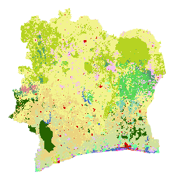
La carte de couverture des sols BNETD 2020 de la Côte d'Ivoire a été produite par le gouvernement ivoirien par le biais d'une institution nationale, le Centre d'information géographique et numérique du Bureau national d'études techniques et de développement (BNETD-CIGN), avec le soutien technique et financier de l'Union européenne. Méthodologie : classification deforestation forest landcover landuse-landcover -
Classification mondiale des forêts en 2020 pour les estimations de biomasse aérienne de niveau 1 de l'IPCC, V1

Cet ensemble de données fournit des classes de forêts mondiales délimitées par état/condition en 2020, avec une résolution d'environ 30 m. Les données permettent de générer des estimations de niveau 1 pour la densité de biomasse ligneuse sèche aérienne (AGBD) dans les forêts naturelles dans la révision de 2019 des directives du GIEC de 2006 pour les inventaires nationaux des gaz à effet de serre… aboveground biomass carbon classification forest forest-biomass -
Carte mondiale PALSAR-2/PALSAR forêt/non-forêt à trois classes

Une version plus récente de cet ensemble de données avec quatre classes pour la période 2017-2020 est disponible dans JAXA/ALOS/PALSAR/YEARLY/FNF4. La carte mondiale des zones forestières et non forestières (FNF) est générée en classant l'image SAR (coefficient de rétrodiffusion) dans la mosaïque SAR PALSAR-2/PALSAR mondiale à une résolution de 25 mètres, de sorte que les pixels à forte et faible rétrodiffusion… alos alos2 classification eroc forest forest-biomass -
Carte mondiale PALSAR-2/PALSAR des forêts/non-forêts à quatre classes

La carte mondiale des forêts et des zones non forestières (FNF) est générée en classant l'image SAR (coefficient de rétrodiffusion) dans la mosaïque SAR PALSAR-2/PALSAR mondiale à une résolution de 25 mètres. Les pixels à forte et faible rétrodiffusion sont respectivement attribués à la catégorie "forêt" et "zone non forestière". Ici, la "forêt" est définie comme la forêt naturelle avec… alos alos2 classification eroc forest forest-biomass
Datasets tagged classification in Earth Engine
[null,null,[],[],[]]