This version of GAUL dataset is simplified at 500m.
The Global Administrative Unit Layers (GAUL) compiles and disseminates the
best available information on administrative units for all the countries in
the world, providing a contribution to the standardization of the spatial
dataset representing administrative units. The GAUL always maintains global
layers with a unified coding system at country, first (e.g. departments),
and second administrative levels (e.g. districts). Where data is available,
it provides layers on a country by country basis down to third, fourth, and
lowers levels. The overall methodology consists in a) collecting the best
available data from most reliable sources, b) establishing validation
periods of the geographic features (when possible), c) adding selected data
to the global layer based on the last country boundaries map provided by
the UN Cartographic Unit (UNCS), d) generating codes using GAUL Coding
System, and e) distribute data to the users
(see Technical Aspects of the GAUL Distribution Set).
Note that some administrative units are multipolygon features.
Table Schema
Table Schema
Name
Type
Description
ADM0_CODE
INT
GAUL country code
ADM0_NAME
STRING
UN country name
DISP_AREA
STRING
Unsettled territory: 'Yes' or 'No'
STATUS
STRING
Status of the country
Shape_Area
DOUBLE
Shape area
Shape_Leng
DOUBLE
Shape length
ADM1_CODE
INT
GAUL code of administrative units at first level
ADM1_NAME
STRING
Name of administrative units at first level
ADM2_CODE
INT
GAUL code of administrative units at second level
ADM2_NAME
STRING
Name of administrative units at second level
EXP2_YEAR
INT
Expiry year of the administrative unit
STR2_YEAR
INT
Creation year of the administrative unit
Terms of Use
Terms of Use
The GAUL dataset is distributed to the United Nations and other authorized
international and national institutions/agencies. FAO grants a license to
use, download and print the materials contained in the GAUL dataset solely
for non-commercial purposes and in accordance with the conditions specified
in the data license.
The full GAUL Data License document
is available for downloading. See also
the disclaimer.
This version of GAUL dataset is simplified at 500m. The Global Administrative Unit Layers (GAUL) compiles and disseminates the best available information on administrative units for all the countries in the world, providing a contribution to the standardization of the spatial dataset representing administrative units. The GAUL always maintains global …
[null,null,[],[[["\u003cp\u003eThe FAO GAUL dataset provides global administrative unit boundaries at country, first, and second administrative levels, with some countries having data down to lower levels.\u003c/p\u003e\n"],["\u003cp\u003eThis dataset is a simplified 500m resolution version and includes attributes like administrative unit names, codes, and status.\u003c/p\u003e\n"],["\u003cp\u003eThe dataset is intended for non-commercial use and is licensed by FAO under specific terms and conditions.\u003c/p\u003e\n"],["\u003cp\u003eEarth Engine provides tools to explore and analyze this dataset, offering visualization and code examples.\u003c/p\u003e\n"],["\u003cp\u003eGAUL aims to standardize administrative unit spatial data, contributing to a consistent global representation of these boundaries.\u003c/p\u003e\n"]]],["The provided dataset, FAO/GAUL_SIMPLIFIED_500m/2015/level2, offers simplified 500m resolution Global Administrative Unit Layers (GAUL) data from 2015. This data, sourced from FAO UN, standardizes spatial administrative units globally, including country, and first and second administrative levels. Users can access and download this non-commercial dataset via the Earth Engine platform, which includes table schemas for coding, naming, and administrative details. The data is available between 2014-12-19T16:45:00Z--2014-12-19T16:45:00Z.\n"],null,["# FAO GAUL 500m Simplified: Global Administrative Unit Layers 2015, Second-Level Administrative Units\n\nDataset Availability\n: 2014-12-19T16:45:00Z--2014-12-19T16:45:00Z\n\nDataset Provider\n:\n\n\n [FAO UN](http://www.fao.org/geonetwork/srv/en/metadata.show?id=12691)\n\nTags\n:\n[borders](/earth-engine/datasets/tags/borders) [county](/earth-engine/datasets/tags/county) [districts](/earth-engine/datasets/tags/districts) [fao](/earth-engine/datasets/tags/fao) [gaul](/earth-engine/datasets/tags/gaul) [infrastructure-boundaries](/earth-engine/datasets/tags/infrastructure-boundaries) [table](/earth-engine/datasets/tags/table) [un](/earth-engine/datasets/tags/un) \n\n#### Description\n\nThis version of GAUL dataset is simplified at 500m.\n\nThe Global Administrative Unit Layers (GAUL) compiles and disseminates the\nbest available information on administrative units for all the countries in\nthe world, providing a contribution to the standardization of the spatial\ndataset representing administrative units. The GAUL always maintains global\nlayers with a unified coding system at country, first (e.g. departments),\nand second administrative levels (e.g. districts). Where data is available,\nit provides layers on a country by country basis down to third, fourth, and\nlowers levels. The overall methodology consists in a) collecting the best\navailable data from most reliable sources, b) establishing validation\nperiods of the geographic features (when possible), c) adding selected data\nto the global layer based on the last country boundaries map provided by\nthe UN Cartographic Unit (UNCS), d) generating codes using GAUL Coding\nSystem, and e) distribute data to the users\n(see [Technical Aspects of the GAUL Distribution Set](https://sgst.wr.usgs.gov/gfsad30/FAO_GUAL/TechnicalAspectsGAUL2015_Doc1.pdf)).\nNote that some administrative units are multipolygon features.\n\n### Table Schema\n\n**Table Schema**\n\n| Name | Type | Description |\n|------------|--------|---------------------------------------------------|\n| ADM0_CODE | INT | GAUL country code |\n| ADM0_NAME | STRING | UN country name |\n| DISP_AREA | STRING | Unsettled territory: 'Yes' or 'No' |\n| STATUS | STRING | Status of the country |\n| Shape_Area | DOUBLE | Shape area |\n| Shape_Leng | DOUBLE | Shape length |\n| ADM1_CODE | INT | GAUL code of administrative units at first level |\n| ADM1_NAME | STRING | Name of administrative units at first level |\n| ADM2_CODE | INT | GAUL code of administrative units at second level |\n| ADM2_NAME | STRING | Name of administrative units at second level |\n| EXP2_YEAR | INT | Expiry year of the administrative unit |\n| STR2_YEAR | INT | Creation year of the administrative unit |\n\n### Terms of Use\n\n**Terms of Use**\n\nThe GAUL dataset is distributed to the United Nations and other authorized\ninternational and national institutions/agencies. FAO grants a license to\nuse, download and print the materials contained in the GAUL dataset solely\nfor non-commercial purposes and in accordance with the conditions specified\nin the data license.\n[The full GAUL Data License document](https://developers.google.com/earth-engine/datasets/catalog/DataLicenseGAUL2015.pdf)\nis available for downloading. See also\n[the disclaimer](https://developers.google.com/earth-engine/datasets/catalog/DisclaimerGAUL2015.pdf).\n\n### 
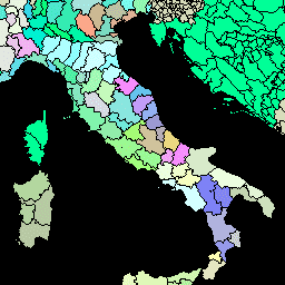
Explore with Earth Engine\n\n| **Important:** Earth Engine is a platform for petabyte-scale scientific analysis and visualization of geospatial datasets, both for public benefit and for business and government users. Earth Engine is free to use for research, education, and nonprofit use. To get started, please [register for Earth Engine access.](https://console.cloud.google.com/earth-engine)\n\n### Code Editor (JavaScript)\n\n```javascript\nvar dataset = ee.FeatureCollection('FAO/GAUL_SIMPLIFIED_500m/2015/level2');\n\nMap.setCenter(12.876, 42.682, 5);\n\nvar styleParams = {\n fillColor: 'b5ffb4',\n color: '00909F',\n width: 1.0,\n};\n\ndataset = dataset.style(styleParams);\n\nMap.addLayer(dataset, {}, 'Second Level Administrative Units');\n```\n[Open in Code Editor](https://code.earthengine.google.com/?scriptPath=Examples:Datasets/FAO/FAO_GAUL_SIMPLIFIED_500m_2015_level2) \n[FAO GAUL 500m Simplified: Global Administrative Unit Layers 2015, Second-Level Administrative Units](/earth-engine/datasets/catalog/FAO_GAUL_SIMPLIFIED_500m_2015_level2) \nThis version of GAUL dataset is simplified at 500m. The Global Administrative Unit Layers (GAUL) compiles and disseminates the best available information on administrative units for all the countries in the world, providing a contribution to the standardization of the spatial dataset representing administrative units. The GAUL always maintains global ... \nFAO/GAUL_SIMPLIFIED_500m/2015/level2, borders,county,districts,fao,gaul,infrastructure-boundaries,table,un \n2014-12-19T16:45:00Z/2014-12-19T16:45:00Z \n-90 -180 90 180 \nGoogle Earth Engine \nhttps://developers.google.com/earth-engine/datasets\n\n- [](https://doi.org/http://www.fao.org/geonetwork/srv/en/metadata.show?id=12691)\n- [](https://doi.org/https://developers.google.com/earth-engine/datasets/catalog/FAO_GAUL_SIMPLIFIED_500m_2015_level2)"]]