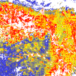
The "Tree Proximate People" (TPP) is one of the datasets contributing to the
development of indicator #13, number of forest-dependent people in extreme
poverty, of the Collaborative Partnership on Forests (CPF) Global Core Set
of forest-related indicators (GCS). The TPP dataset provides 4 different
estimates of tree proximate people (trees outside forests), all of them for
the year 2019 with a pixel size of 100 meters at a global level.
Find out more about the dataset.
Bands
Pixel Size 0.0009 meters
Bands
Name
Units
Pixel Size
Description
TPP_1km
Number of people/ha
meters
Number of people living in or within 1 km from agricultural lands
with at least 10% of tree cover
TPP_1km_cropland
Number of people/ha
meters
Number of people living in or within 1 km from croplands with at
least 10% of tree cover
TPP_500m
Number of people/ha
meters
Number of people living in or within 500 m from agricultural lands
with at least 10% of tree cover
TPP_500m_cropland
Number of people/ha
meters
Number of people living in or within 500 m from croplands with at
least 10% of tree cover
FAO 2022. The State of the World's Forests (SOFO) - Forest pathways for
green recovery and building inclusive, resilient and sustainable
economies. FAO, Rome.
https://www.fao.org/documents/card/en/c/cb9360en
Newton, P., Castle, S.E., Kinzer, A.T., Miller, D.C., Oldekop, J.A.,
Linhares-Juvenal, T., Pina, L., Madrid, M., & de Lamo, J. 2022. The
number of forest- and tree-proximate people: a new methodology and
global estimates, One Earth, 2020
doi:10.1016/j.oneear.2020.08.016,
The "Tree Proximate People" (TPP) is one of the datasets contributing to the development of indicator #13, number of forest-dependent people in extreme poverty, of the Collaborative Partnership on Forests (CPF) Global Core Set of forest-related indicators (GCS). The TPP dataset provides 4 different estimates of tree proximate people (trees …
[null,null,[],[[["\u003cp\u003eThe Tree Proximate People (TPP) dataset provides estimates of people living near trees outside of forests, contributing to the understanding of forest-dependent populations.\u003c/p\u003e\n"],["\u003cp\u003eThis global dataset offers four estimates for 2019, based on proximity (500m or 1km) to agricultural lands or croplands with at least 10% tree cover.\u003c/p\u003e\n"],["\u003cp\u003eData is available at a 100-meter resolution and is accessible through Google Earth Engine.\u003c/p\u003e\n"],["\u003cp\u003eThe dataset is licensed under CC-BY-4.0 and supports research on forest-related indicators and sustainable economies.\u003c/p\u003e\n"],["\u003cp\u003eThe dataset was created by FAO and is available through their data catalog.\u003c/p\u003e\n"]]],[],null,["# Tree proximate people (TPP) 1.0\n\nDataset Availability\n: 2019-01-01T00:00:00Z--2019-01-01T00:00:00Z\n\nDataset Provider\n:\n\n\n [FAO Forestry Division (TPP 500m cropland)](https://data.apps.fao.org/catalog/iso/8ed893bd-842a-4866-a655-a0a0c02b79b8)\n\n\n [FAO Forestry Division (TPP 1km cropland)](https://data.apps.fao.org/catalog/iso/8ed893bd-842a-4866-a655-a0a0c02b79b6)\n\n\n [FAO Forestry Division (TPP 500m agricultural)](https://data.apps.fao.org/catalog/iso/8ed893bd-842a-4866-a655-a0a0c02b79b7)\n\n\n [FAO Forestry Division (TPP 1km agricultural)](https://data.apps.fao.org/catalog/iso/8ed893bd-842a-4866-a655-a0a0c02b79b3)\n\nCadence\n: 1 Year\n\nTags\n:\n[agriculture](/earth-engine/datasets/tags/agriculture) [fao](/earth-engine/datasets/tags/fao) [forest](/earth-engine/datasets/tags/forest) [global](/earth-engine/datasets/tags/global) [plant-productivity](/earth-engine/datasets/tags/plant-productivity) [population](/earth-engine/datasets/tags/population) [rural-area](/earth-engine/datasets/tags/rural-area) \n\n#### Description\n\nThe \"Tree Proximate People\" (TPP) is one of the datasets contributing to the\ndevelopment of indicator #13, number of forest-dependent people in extreme\npoverty, of the Collaborative Partnership on Forests (CPF) Global Core Set\nof forest-related indicators (GCS). The TPP dataset provides 4 different\nestimates of tree proximate people (trees outside forests), all of them for\nthe year 2019 with a pixel size of 100 meters at a global level.\n[Find out more about the dataset.](https://data.apps.fao.org/catalog/dcat/tree-proximate-people)\n\n### Bands\n\n\n**Pixel Size**\n\n0.0009 meters\n\n**Bands**\n\n| Name | Units | Pixel Size | Description |\n|---------------------|---------------------|------------|----------------------------------------------------------------------------------------------------|\n| `TPP_1km` | Number of people/ha | meters | Number of people living in or within 1 km from agricultural lands with at least 10% of tree cover |\n| `TPP_1km_cropland` | Number of people/ha | meters | Number of people living in or within 1 km from croplands with at least 10% of tree cover |\n| `TPP_500m` | Number of people/ha | meters | Number of people living in or within 500 m from agricultural lands with at least 10% of tree cover |\n| `TPP_500m_cropland` | Number of people/ha | meters | Number of people living in or within 500 m from croplands with at least 10% of tree cover |\n\n### Terms of Use\n\n**Terms of Use**\n\n[CC-BY-4.0](https://spdx.org/licenses/CC-BY-4.0.html)\n\n### Citations\n\nCitations:\n\n- FAO 2022. The State of the World's Forests (SOFO) - Forest pathways for\n green recovery and building inclusive, resilient and sustainable\n economies. FAO, Rome.\n \u003chttps://www.fao.org/documents/card/en/c/cb9360en\u003e\n- Newton, P., Castle, S.E., Kinzer, A.T., Miller, D.C., Oldekop, J.A.,\n Linhares-Juvenal, T., Pina, L., Madrid, M., \\& de Lamo, J. 2022. The\n number of forest- and tree-proximate people: a new methodology and\n global estimates, One Earth, 2020\n [doi:10.1016/j.oneear.2020.08.016](https://doi.org/10.1016/j.oneear.2020.08.016),\n\n### DOIs\n\n- \u003chttps://doi.org/10.1016/j.oneear.2020.08.016\u003e\n\n### Explore with Earth Engine\n\n| **Important:** Earth Engine is a platform for petabyte-scale scientific analysis and visualization of geospatial datasets, both for public benefit and for business and government users. Earth Engine is free to use for research, education, and nonprofit use. To get started, please [register for Earth Engine access.](https://console.cloud.google.com/earth-engine)\n\n### Code Editor (JavaScript)\n\n```javascript\nvar coll = ee.ImageCollection('FAO/SOFO/1/TPP');\nvar image = coll.first().select('TPP_1km');\nMap.setCenter(17.5, 20, 3);\nMap.addLayer(\n image, {min: 0, max: 12, palette: ['blue', 'yellow', 'red']},\n 'Tree proximate people -- 1km cutoff distance');\n```\n[Open in Code Editor](https://code.earthengine.google.com/?scriptPath=Examples:Datasets/FAO/FAO_SOFO_1_TPP) \n[Tree proximate people (TPP) 1.0](/earth-engine/datasets/catalog/FAO_SOFO_1_TPP) \nThe \"Tree Proximate People\" (TPP) is one of the datasets contributing to the development of indicator #13, number of forest-dependent people in extreme poverty, of the Collaborative Partnership on Forests (CPF) Global Core Set of forest-related indicators (GCS). The TPP dataset provides 4 different estimates of tree proximate people (trees ... \nFAO/SOFO/1/TPP, agriculture,fao,forest,global,plant-productivity,population,rural-area \n2019-01-01T00:00:00Z/2019-01-01T00:00:00Z \n-90 -180 90 180 \nGoogle Earth Engine \nhttps://developers.google.com/earth-engine/datasets\n\n- [https://doi.org/10.1016/j.oneear.2020.08.016](https://doi.org/https://data.apps.fao.org/catalog/iso/8ed893bd-842a-4866-a655-a0a0c02b79b8)\n- [https://doi.org/10.1016/j.oneear.2020.08.016](https://doi.org/https://data.apps.fao.org/catalog/iso/8ed893bd-842a-4866-a655-a0a0c02b79b6)\n- [https://doi.org/10.1016/j.oneear.2020.08.016](https://doi.org/https://data.apps.fao.org/catalog/iso/8ed893bd-842a-4866-a655-a0a0c02b79b7)\n- [https://doi.org/10.1016/j.oneear.2020.08.016](https://doi.org/https://data.apps.fao.org/catalog/iso/8ed893bd-842a-4866-a655-a0a0c02b79b3)\n- [https://doi.org/10.1016/j.oneear.2020.08.016](https://doi.org/https://developers.google.com/earth-engine/datasets/catalog/FAO_SOFO_1_TPP)"]]