- 데이터 세트 제공
- 2024-03-16T00:00:00Z–2024-03-16T23:59:59Z
- 데이터 세트 제공업체
- Joint Research Centre
- 태그
설명
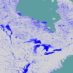
전 세계 하천 홍수 위험 지도는 7가지 다른 홍수 재현 주기(10년에 한 번에서 500년에 한 번)에 대해 하천 네트워크를 따라 침수를 나타내는 그리드 데이터 세트입니다. 새 지도의 입력 하천 흐름 데이터는 오픈소스 수문학 모델 LISFLOOD를 통해 생성되며, 침수 시뮬레이션은 수력학 모델 LISFLOOD-FP를 사용하여 실행됩니다. 범위는 그린란드와 남극, 강 유역이 500km^2보다 작은 소규모 섬을 제외한 전 세계를 포함합니다.
셀 값은 수심 (미터)을 나타냅니다. 이 지도는 인구와 경제 자산의 하천 홍수 노출을 평가하고 홍수 위험 평가를 수행하는 데 사용할 수 있습니다. 이 데이터 세트는 Copernicus Emergency Management Service의 일부로 생성됩니다.
이 버전에는 추가 데이터 세트도 포함되어 있습니다. 각 타일에는 GloFAS의 '홍수 위험 100년 재발 주기' 정적 레이어에 따라 분류된 수심이 포함된 홍수 위험 지도가 제공됩니다. 또한 'spurious_depth_category' 밴드는 2km 버퍼를 포함하여 10년 반환 기간 동안 작은 채널 (3,000km^2 미만)에서 10m보다 큰 깊이가 예측되는 영역을 식별합니다.
대역
픽셀 크기
90m
대역
| 이름 | 단위 | 최소 | 최대 | 픽셀 크기 | 설명 |
|---|---|---|---|---|---|
RP10_depth |
m | 0.1 | 160 | 미터 | 10년 반환 기간의 홍수 침수 깊이 |
RP20_depth |
m | 0.1 | 199 | 미터 | 20년 회귀 기간의 홍수 침수 깊이 |
RP50_depth |
m | 0.1 | 258.1 | 미터 | 50년 반환 기간의 홍수 침수 깊이 |
RP75_depth |
m | 0.1 | 283.6 | 미터 | 75년 회귀 기간의 홍수 침수 깊이 |
RP100_depth |
m | 0.1 | 301.6 | 미터 | 100년 반환 기간의 홍수 침수 깊이 |
RP200_depth |
m | 0.1 | 344.8 | 미터 | 반환 기간 200년의 홍수 침수 깊이 |
RP500_depth |
m | 0.1 | 401.3 | 미터 | 500년 회귀 기간의 홍수 침수 깊이 |
RP10_depth_category |
2 | 4 | 미터 | 재발 주기 10년에 대한 GloFAS 홍수 위험 100년 재발 주기 정적 레이어로 분류된 수심 |
|
RP20_depth_category |
2 | 4 | 미터 | 재발 주기 20년의 GloFAS 홍수 위험 100년 재발 주기 정적 레이어로 분류된 수심 |
|
RP50_depth_category |
2 | 4 | 미터 | 재발 주기 50년에 대한 GloFAS 홍수 위험 100년 재발 주기 정적 레이어로 분류된 수심 |
|
RP75_depth_category |
2 | 4 | 미터 | 재발 주기 75년에 대한 GloFAS 홍수 위험 100년 재발 주기 정적 레이어로 분류된 수심 |
|
RP100_depth_category |
2 | 4 | 미터 | 재발 주기 100년에 대한 GloFAS 홍수 위험 100년 재발 주기 정적 레이어로 분류된 수심 |
|
RP200_depth_category |
2 | 4 | 미터 | 재발 주기 200년에 대한 GloFAS 홍수 위험 100년 재발 주기 정적 레이어로 분류된 수심 |
|
RP500_depth_category |
2 | 4 | 미터 | 재발 주기 500년의 GloFAS 홍수 위험 100년 재발 주기 정적 레이어로 분류된 수심 |
|
permanent_water_class |
1 | 1 | 미터 | 홍수 위험 지도를 패치하는 데 사용되는 영구 수역 |
|
spurious_depth_category |
1 | 1 | 미터 | 10년 반환 기간 동안 작은 채널(<3,000km^2)에서 깊이가 10m를 초과하는 것으로 예측되는 영역과 2km 버퍼를 식별합니다. |
이미지 속성
이미지 속성
| 이름 | 유형 | 설명 |
|---|---|---|
| id | INT | 위도/경도 그리드 셀의 고유 식별자입니다. |
이용약관
이용약관
JRC 데이터 세트는 사용 또는 배포에 제한이 없습니다. 자세한 내용은 액세스 권한을 확인하세요.
인용
Baugh, Calum; Colonese, Juan; D'Angelo, Claudia; Dottori, Francesco; Neal, Jeffrey; Prudhomme, Christel; Salamon, Peter (2024): Global river flood hazard maps. European Commission, Joint Research Centre (JRC) [데이터 세트] PID: http://data.europa.eu/89h/jrc-floods-floodmapgl_rp50y-tif
DOI
Earth Engine으로 탐색
코드 편집기(JavaScript)
var dataset = ee.ImageCollection('JRC/CEMS_GLOFAS/FloodHazard/v2_1');
var depth = dataset.select('RP100_depth');
var depthVis = {
  min: 0,
  max: 1,
  palette: ['ffffff','0000ff'],
};
Map.setCenter(-86.47, 47.28, 4);
Map.addLayer(depth, depthVis, 'JRC Flood Hazard Maps V2.1');