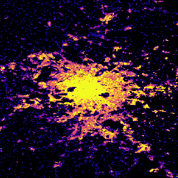
이 공간 래스터 데이터 세트는 2018년을 기준으로 100m 해상도의 전 세계 건물 높이 분포를 보여줍니다. 건물 높이를 예측하는 데 사용된 입력 데이터는 ALOS 전역 디지털 지표 모델(30m), NASA 셔틀 레이더 지형 임무 데이터 (30m), 2017~2018년 기간의 L1C 데이터로 구성된 전역 Sentinel-2 이미지입니다.
GHSL 데이터 제품에 관한 자세한 내용은 GHSL 데이터 패키지 2023 보고서에서 확인할 수 있습니다. 여기에서 건물 높이 레이어는 평균 순 건물 높이 (ANBH)로 언급됩니다.
Global Human Settlement Layer (GHSL) 프로젝트는 유럽 위원회, 공동연구센터, 지역 및 도시 정책 총국에서 지원합니다.
대역
픽셀 크기 100미터
대역
이름
단위
픽셀 크기
설명
built_height
m
미터
그리드 셀당 평균 건물 높이
이용약관
이용약관
GHSL은 유럽연합 집행위원회 공동 연구 센터에서 개방형 무료 데이터로 제작했습니다. 출처를 표시하는 경우 재사용이 허용됩니다. 자세한 내용은 사용 조건 (유럽 위원회 재사용 및 저작권 고지)을 참고하세요.
방법론 : Pesaresi, Martino, Marcello Schiavina, Panagiotis Politis,
Sergio Freire, Katarzyna Krasnodebska,
Johannes H. Uhl, Alessandra Carioli, et al. (2024). 지구 관측 및 인구 조사 데이터의 공동 평가를 통한 전 세계 거주지 레이어의 발전 International Journal of Digital Earth 17(1).
doi:10.1080/17538947.2024.2390454.
[null,null,[],[[["\u003cp\u003eThis dataset provides a global view of building heights at a 100-meter resolution for the year 2018.\u003c/p\u003e\n"],["\u003cp\u003eBuilding heights were estimated using ALOS, SRTM, and Sentinel-2 data.\u003c/p\u003e\n"],["\u003cp\u003eThe dataset is provided by the European Commission Joint Research Centre (JRC) and is freely available for reuse with attribution.\u003c/p\u003e\n"],["\u003cp\u003eAverage building height is represented in meters within a single band named 'built_height'.\u003c/p\u003e\n"],["\u003cp\u003eUsers can explore and analyze this dataset further within the Google Earth Engine platform.\u003c/p\u003e\n"]]],["The dataset provides the global distribution of building heights for 2018 at a 100-meter resolution, sourced from the EC JRC. It utilizes ALOS, SRTM, and Sentinel-2 data. Data access is available via Earth Engine using the provided snippet `ee.ImageCollection(\"JRC/GHSL/P2023A/GHS_BUILT_H\")`. The \"built_height\" band measures average building height in meters per grid cell. This data is free to use with proper source acknowledgement.\n"],null,["# GHSL: Global building height 2018 (P2023A)\n\nDataset Availability\n: 2018-01-01T00:00:00Z--2018-12-31T00:00:00Z\n\nDataset Provider\n:\n\n\n [EC JRC](https://ghsl.jrc.ec.europa.eu/ghs_buH2023.php)\n\nTags\n:\n[alos](/earth-engine/datasets/tags/alos) [building](/earth-engine/datasets/tags/building) [built](/earth-engine/datasets/tags/built) [built-environment](/earth-engine/datasets/tags/built-environment) [builtup](/earth-engine/datasets/tags/builtup) [copernicus](/earth-engine/datasets/tags/copernicus) [dem](/earth-engine/datasets/tags/dem) [ghsl](/earth-engine/datasets/tags/ghsl) [height](/earth-engine/datasets/tags/height) [jrc](/earth-engine/datasets/tags/jrc) [population](/earth-engine/datasets/tags/population) [sdg](/earth-engine/datasets/tags/sdg) [sentinel2-derived](/earth-engine/datasets/tags/sentinel2-derived) [srtm](/earth-engine/datasets/tags/srtm) [urban](/earth-engine/datasets/tags/urban) \n\n#### Description\n\nThis spatial raster dataset depicts the global distribution of building\nheights at a resolution of 100 m, referred to the year 2018. The input data\nused to predict building heights are the ALOS Global Digital Surface Model\n(30 m), the NASA Shuttle Radar Topographic Mission data (30 m), and a global\nSentinel-2 image composite from L1C data for the period 2017-2018.\n\nMore information about the GHSL data products can be found in the\n[GHSL Data Package 2023 report](https://ghsl.jrc.ec.europa.eu/documents/GHSL_Data_Package_2023.pdf?t=1683540422),\nwhere the building height layer is referred to as the Average Net Building\nHeight (ANBH).\n\nThe Global Human Settlement Layer (GHSL) project is supported by the\nEuropean Commission, Joint Research Centre, and Directorate-General for\nRegional and Urban Policy.\n\n### Bands\n\n\n**Pixel Size**\n\n100 meters\n\n**Bands**\n\n| Name | Units | Pixel Size | Description |\n|----------------|-------|------------|---------------------------------------|\n| `built_height` | m | meters | Average building height per grid cell |\n\n### Terms of Use\n\n**Terms of Use**\n\nThe GHSL has been produced by the European Commission Joint Research Centre\nas open and free data. Reuse is authorised, provided the source is\nacknowledged. For more information, please read the use conditions ([European\nCommission Reuse and Copyright Notice](https://ec.europa.eu/info/legal-notice_en)).\n\n### Citations\n\nCitations:\n\n- Dataset : Pesaresi, Martino; Politis, Panagiotis (2023): GHS-BUILT-H\n R2023A - GHS building height, derived from AW3D30, SRTM30, and Sentinel2\n composite (2018). European Commission, Joint Research Centre (JRC)\n [PID: http://data.europa.eu/89h/85005901-3a49-48dd-9d19-6261354f56fe](http://data.europa.eu/89h/85005901-3a49-48dd-9d19-6261354f56fe)\n [doi:10.2905/85005901-3A49-48DD-9D19-6261354F56FE](https://doi.org/10.2905/85005901-3A49-48DD-9D19-6261354F56FE)\n- Methodology : Pesaresi, Martino, Marcello Schiavina, Panagiotis Politis,\n Sergio Freire, Katarzyna Krasnodebska,\n Johannes H. Uhl, Alessandra Carioli, et al. (2024). Advances on the\n Global Human Settlement Layer by Joint Assessment of Earth Observation\n and Population Survey Data. International Journal of Digital Earth 17(1).\n [doi:10.1080/17538947.2024.2390454](https://doi.org/10.1080/17538947.2024.2390454).\n\n### DOIs\n\n- \u003chttps://doi.org/10.1080/17538947.2024.2390454\u003e\n- \u003chttps://doi.org/10.2905/85005901-3A49-48DD-9D19-6261354F56FE\u003e\n\n### Explore with Earth Engine\n\n| **Important:** Earth Engine is a platform for petabyte-scale scientific analysis and visualization of geospatial datasets, both for public benefit and for business and government users. Earth Engine is free to use for research, education, and nonprofit use. To get started, please [register for Earth Engine access.](https://console.cloud.google.com/earth-engine)\n\n### Code Editor (JavaScript)\n\n```javascript\nvar image = ee.Image(\"JRC/GHSL/P2023A/GHS_BUILT_H/2018\");\nvar built = image.select('built_height');\nvar visParams = {\n min: 0.0,\n max: 12.0,\n palette: ['000000', '0d0887', '7e03a8', 'cc4778', 'f89540', 'f0f921'],\n};\n\nMap.setCenter(2.349014, 48.864716, 10);\nMap.addLayer(built, visParams, 'Average building height [m], 2018');\n```\n[Open in Code Editor](https://code.earthengine.google.com/?scriptPath=Examples:Datasets/JRC/JRC_GHSL_P2023A_GHS_BUILT_H) \n[GHSL: Global building height 2018 (P2023A)](/earth-engine/datasets/catalog/JRC_GHSL_P2023A_GHS_BUILT_H) \nThis spatial raster dataset depicts the global distribution of building heights at a resolution of 100 m, referred to the year 2018. The input data used to predict building heights are the ALOS Global Digital Surface Model (30 m), the NASA Shuttle Radar Topographic Mission data (30 m), and a ... \nJRC/GHSL/P2023A/GHS_BUILT_H, alos,building,built,built-environment,builtup,copernicus,dem,ghsl,height,jrc,population,sdg,sentinel2-derived,srtm,urban \n2018-01-01T00:00:00Z/2018-12-31T00:00:00Z \n-90 -180 90 180 \nGoogle Earth Engine \nhttps://developers.google.com/earth-engine/datasets\n\n- [https://doi.org/10.2905/85005901-3A49-48DD-9D19-6261354F56FE](https://doi.org/https://ghsl.jrc.ec.europa.eu/ghs_buH2023.php)\n- [https://doi.org/10.2905/85005901-3A49-48DD-9D19-6261354F56FE](https://doi.org/https://developers.google.com/earth-engine/datasets/catalog/JRC_GHSL_P2023A_GHS_BUILT_H)"]]