-
GHSL: 2018년 전 세계 건물 높이 (P2023A)
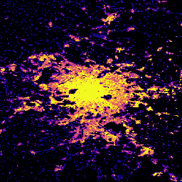
이 공간 래스터 데이터 세트는 2018년을 기준으로 100m 해상도의 전 세계 건물 높이 분포를 보여줍니다. 건물 높이를 예측하는 데 사용되는 입력 데이터는 ALOS Global Digital Surface Model (30m), NASA Shuttle Radar Topographic Mission … alos building built built-environment builtup copernicus -
GHSL: 전 세계 건물 표면 10m (P2023A)
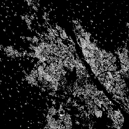
이 래스터 데이터세트는 S2 이미지 데이터에서 관찰된 2018년의 10m 그리드 셀당 제곱미터로 표현된 건물 표면의 분포를 보여줍니다. 데이터 세트는 a) 총 건물 표면과 b) …의 그리드 셀에 할당된 건물 표면을 측정합니다. built built-environment builtup copernicus ghsl jrc -
GHSL: 전 세계 건축 표면 1975~2030년 (P2023A)
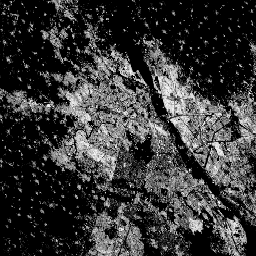
이 래스터 데이터 세트는 100m 그리드 셀당 제곱미터로 표현된 건물 표면의 분포를 보여줍니다. 이 데이터 세트는 a) 총 건물 표면과 b) 비주거용 (NRES) 용도가 주를 이루는 그리드 셀에 할당된 건물 표면을 측정합니다. 데이터가 시공간적으로 보간되거나 … built built-environment builtup copernicus ghsl jrc -
GHSL: 전 세계 정착지 특성 (10m) 2018 (P2023A)
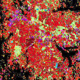
이 공간 래스터 데이터 세트는 10m 해상도로 인적 거주지를 나타내며, 건축 환경의 기능 및 높이 관련 구성요소 측면에서 내부 특성을 설명합니다. GHSL 데이터 제품에 대한 자세한 내용은 GHSL 데이터 패키지 2023 보고서에서 확인할 수 있습니다. building built builtup copernicus ghsl height -
Tsinghua FROM-GLC Year of Change to Impervious Surface(칭화대 FROM-GLC 불투수 표면으로의 변화 연도)

이 데이터 세트에는 1985년부터 2018년까지의 전 세계 불투수면적의 연간 변화 정보가 30m 해상도로 포함되어 있습니다. 이전에서 불투과성으로의 변경은 감독 분류와 시간적 일관성 검사의 결합된 접근 방식을 사용하여 결정되었습니다. 불투수성 픽셀은 불투수성이 50% 이상인 것으로 정의됩니다. … built population tsinghua urban
Datasets tagged built in Earth Engine
[null,null,[],[],[]]