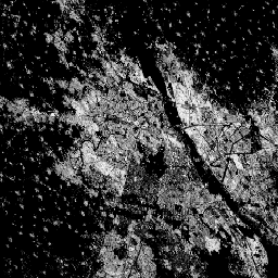
이 래스터 데이터 세트는 100m 그리드 셀당 제곱미터로 표현된 건물 표면의 분포를 보여줍니다.
데이터 세트는 a) 총 건축 면적과 b) 주요 비주거용 (NRES) 용도의 그리드 셀에 할당된 건축 면적을 측정합니다. 데이터는 5년 간격으로 1975년부터 2030년까지 공간-시간적으로 보간되거나 외삽됩니다.
방법론 : Pesaresi, Martino, Marcello Schiavina, Panagiotis Politis,
Sergio Freire, Katarzyna Krasnodebska,
Johannes H. Uhl, Alessandra Carioli, et al. (2024). 지구 관측 및 인구 조사 데이터의 공동 평가를 통한 전 세계 거주지 레이어의 발전 International Journal of Digital Earth 17(1).
doi:10.1080/17538947.2024.2390454.
이 래스터 데이터 세트는 100m 그리드 셀당 제곱미터로 표현된 건물 표면의 분포를 보여줍니다. 이 데이터 세트는 a) 총 건물 표면과 b) 비주거용 (NRES) 용도가 주를 이루는 그리드 셀에 할당된 건물 표면을 측정합니다. 데이터는 1975년부터 2030년까지 시공간적으로 보간되거나 추정됩니다.
[null,null,[],[[["\u003cp\u003eThe Global Human Settlement Layer (GHSL) dataset provides data on built-up surfaces globally, including residential and non-residential areas, at a 100-meter resolution.\u003c/p\u003e\n"],["\u003cp\u003eIt offers temporal coverage from 1975 to 2030 in 5-year intervals, with data spatially-temporally interpolated or extrapolated.\u003c/p\u003e\n"],["\u003cp\u003eDeveloped by the European Commission Joint Research Centre, the dataset is freely available for reuse with proper attribution.\u003c/p\u003e\n"],["\u003cp\u003eThe GHSL dataset is derived from Sentinel-2 and Landsat imagery and provides insights into global urbanization trends.\u003c/p\u003e\n"],["\u003cp\u003eBuilt-up surface is measured in square meters per grid cell and includes both total and non-residential built-up areas.\u003c/p\u003e\n"]]],["The dataset, provided by EC JRC, spans 1975-2030, presenting built-up surface distribution in square meters per 100m grid cell. It quantifies total built-up area and non-residential (NRES) built-up area, extrapolated every five years. The data, available through Earth Engine, includes `built_surface` and `built_surface_nres` bands at 100-meter resolution. It is free to use, and reuse is authorized, provided the source is acknowledged. This information can be explored in the Code Editor.\n"],null,["# GHSL: Global built-up surface 1975-2030 (P2023A)\n\nDataset Availability\n: 1975-01-01T00:00:00Z--2030-12-31T00:00:00Z\n\nDataset Provider\n:\n\n\n [EC JRC](https://ghsl.jrc.ec.europa.eu/ghs_buS2023.php)\n\nTags\n:\n[built](/earth-engine/datasets/tags/built) [built-environment](/earth-engine/datasets/tags/built-environment) [builtup](/earth-engine/datasets/tags/builtup) [copernicus](/earth-engine/datasets/tags/copernicus) [ghsl](/earth-engine/datasets/tags/ghsl) [jrc](/earth-engine/datasets/tags/jrc) [landcover](/earth-engine/datasets/tags/landcover) [landsat-derived](/earth-engine/datasets/tags/landsat-derived) [population](/earth-engine/datasets/tags/population) [sdg](/earth-engine/datasets/tags/sdg) [sentinel2-derived](/earth-engine/datasets/tags/sentinel2-derived) [settlement](/earth-engine/datasets/tags/settlement) [urban](/earth-engine/datasets/tags/urban) \n\n#### Description\n\nThis raster dataset depicts the distribution of built-up surfaces,\nexpressed in square metres per 100 m grid cell.\nThe dataset measures:\na) the total built-up surface, and b) the built-up surface allocated to grid\ncells of predominant non-residential (NRES) use. Data are\nspatially-temporally interpolated or extrapolated from 1975 to 2030 in 5\nyear intervals.\n\nThe complete information about the GHSL main products can be\nfound in the [GHSL Data Package 2023 report](https://ghsl.jrc.ec.europa.eu/documents/GHSL_Data_Package_2023.pdf?t=1683540422)\n\nThe Global Human Settlement Layer (GHSL) project is supported by the\nEuropean Commission, Joint Research Centre, and Directorate-General for\nRegional and Urban Policy.\n\n### Bands\n\n\n**Pixel Size**\n\n100 meters\n\n**Bands**\n\n| Name | Units | Pixel Size | Description |\n|----------------------|-------|------------|------------------------------------------------|\n| `built_surface` | m\\^2 | meters | Built-up surface per grid cell |\n| `built_surface_nres` | m\\^2 | meters | Non-residential built-up surface per grid cell |\n\n### Terms of Use\n\n**Terms of Use**\n\nThe GHSL has been produced by the European Commission Joint Research Centre\nas open and free data. Reuse is authorised, provided the source is\nacknowledged. For more information, please read the use conditions ([European\nCommission Reuse and Copyright Notice](https://ec.europa.eu/info/legal-notice_en)).\n\n### Citations\n\nCitations:\n\n- Dataset : Pesaresi, Martino; Politis, Panagiotis (2023): GHS-BUILT-S\n R2023A - GHS built-up surface grid, derived from Sentinel2 composite and\n Landsat, multitemporal (1975-2030). European Commission, Joint Research\n Centre (JRC).\n [PID: http://data.europa.eu/89h/9f06f36f-4b11-47ec-abb0-4f8b7b1d72ea](http://data.europa.eu/89h/9f06f36f-4b11-47ec-abb0-4f8b7b1d72ea)\n [doi:10.2905/9F06F36F-4B11-47EC-ABB0-4F8B7B1D72EA](https://doi.org/10.2905/9F06F36F-4B11-47EC-ABB0-4F8B7B1D72EA)\n- Methodology : Pesaresi, Martino, Marcello Schiavina, Panagiotis Politis,\n Sergio Freire, Katarzyna Krasnodebska,\n Johannes H. Uhl, Alessandra Carioli, et al. (2024). Advances on the\n Global Human Settlement Layer by Joint Assessment of Earth Observation\n and Population Survey Data. International Journal of Digital Earth 17(1).\n [doi:10.1080/17538947.2024.2390454](https://doi.org/10.1080/17538947.2024.2390454).\n\n### DOIs\n\n- \u003chttps://doi.org/10.1080/17538947.2024.2390454\u003e\n- \u003chttps://doi.org/10.2905/9F06F36F-4B11-47EC-ABB0-4F8B7B1D72EA\u003e\n\n### Explore with Earth Engine\n\n| **Important:** Earth Engine is a platform for petabyte-scale scientific analysis and visualization of geospatial datasets, both for public benefit and for business and government users. Earth Engine is free to use for research, education, and nonprofit use. To get started, please [register for Earth Engine access.](https://console.cloud.google.com/earth-engine)\n\n### Code Editor (JavaScript)\n\n```javascript\nvar image_1975 = ee.Image('JRC/GHSL/P2023A/GHS_BUILT_S/1975');\nvar built_1975 = image_1975.select('built_surface');\nvar image_2020 = ee.Image('JRC/GHSL/P2023A/GHS_BUILT_S/2020');\nvar built_2020 = image_2020.select('built_surface');\nvar visParams = {min: 0.0, max: 8000.0, palette: ['000000', 'FFFFFF']};\n\nMap.setCenter(77.156, 28.6532, 10);\nMap.addLayer(built_1975, visParams, 'Built-up surface [m2], 1975');\nMap.addLayer(built_2020, visParams, 'Built-up surface [m2], 2020');\n```\n[Open in Code Editor](https://code.earthengine.google.com/?scriptPath=Examples:Datasets/JRC/JRC_GHSL_P2023A_GHS_BUILT_S) \n[GHSL: Global built-up surface 1975-2030 (P2023A)](/earth-engine/datasets/catalog/JRC_GHSL_P2023A_GHS_BUILT_S) \nThis raster dataset depicts the distribution of built-up surfaces, expressed in square metres per 100 m grid cell. The dataset measures: a) the total built-up surface, and b) the built-up surface allocated to grid cells of predominant non-residential (NRES) use. Data are spatially-temporally interpolated or extrapolated from 1975 to 2030 ... \nJRC/GHSL/P2023A/GHS_BUILT_S, built,built-environment,builtup,copernicus,ghsl,jrc,landcover,landsat-derived,population,sdg,sentinel2-derived,settlement,urban \n1975-01-01T00:00:00Z/2030-12-31T00:00:00Z \n-90 -180 90 180 \nGoogle Earth Engine \nhttps://developers.google.com/earth-engine/datasets\n\n- [https://doi.org/10.2905/9F06F36F-4B11-47EC-ABB0-4F8B7B1D72EA](https://doi.org/https://ghsl.jrc.ec.europa.eu/ghs_buS2023.php)\n- [https://doi.org/10.2905/9F06F36F-4B11-47EC-ABB0-4F8B7B1D72EA](https://doi.org/https://developers.google.com/earth-engine/datasets/catalog/JRC_GHSL_P2023A_GHS_BUILT_S)"]]