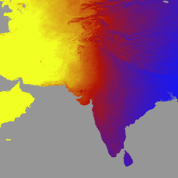
MCD18A1 버전 6.1은 1km 픽셀 해상도로 매일 생성되고 3시간마다 DSR 추정치가 포함된 중간 해상도 이미징 분광계(MODIS) Terra 및 Aqua 결합 하향 단파 복사 (DSR) 그리드 레벨 3 제품입니다. DSR은 단파 스펙트럼 (300~4,000나노미터)에서 육지 표면에 대한 입사 태양 복사이며 다양한 과학 및 애플리케이션 문제를 다루는 육지 표면 모델에서 중요한 변수입니다. MCD18 제품은 MODIS 데이터의 다중 시간 서명을 사용하여 표면 반사율을 도출한 다음 조회표 (LUT) 접근 방식을 사용하여 입사 DSR을 계산하는 프로토타입 알고리즘을 기반으로 합니다. LUT는 다양한 조명/보기 지오메트리에서 다양한 유형의 에어로졸 및 구름 로딩을 고려합니다. 글로벌 DSR 제품은 MODIS 및 정지궤도 위성 데이터에서 생성됩니다.
데이터 생성에 사용된 방법론에 관한 자세한 내용은 알고리즘 이론적 근거 문서를 참고하세요.
대역
픽셀 크기 500미터
대역
이름
단위
최소
최대
픽셀 크기
설명
DSR
W/m^2
0
1400
미터
MODIS 통과 시점의 순간 총 DSR
Direct
W/m^2
0
1400
미터
MODIS 고가차도에서 즉각적인 직접 DSR
Diffuse
W/m^2
0
1400
미터
MODIS 통과 시 순간적인 확산 DSR
GMT_0000_DSR
W/m^2
0
1400
미터
GMT 00:00의 총 DSR
GMT_0300_DSR
W/m^2
0
1400
미터
GMT 03:00의 총 DSR
GMT_0600_DSR
W/m^2
0
1400
미터
GMT 06:00의 총 DSR
GMT_0900_DSR
W/m^2
0
1400
미터
GMT 09:00의 총 DSR
GMT_1200_DSR
W/m^2
0
1400
미터
GMT 12:00의 총 DSR
GMT_1500_DSR
W/m^2
0
1400
미터
GMT 15:00의 총 DSR
GMT_1800_DSR
W/m^2
0
1400
미터
GMT 18:00의 총 DSR
GMT_2100_DSR
W/m^2
0
1400
미터
GMT 21:00의 총 DSR
DSR_Quality
미터
품질 플래그
DSR_Quality의 비트 마스크
비트 0~1: 표면 반사율 데이터의 입력 소스
0: 유효한 표면 반사율 데이터가 없음
1: MCD43 제품에서
2: 기후학 데이터
이용약관
이용약관
LP DAAC를 통해 획득한 MODIS 데이터 및 제품은 후속 사용, 판매 또는 재배포에 제한이 없습니다.
MCD18A1 버전 6.1은 Moderate Resolution Imaging Spectroradiometer (MODIS) Terra 및 Aqua가 결합된 하향 단파 복사 (DSR) 그리드 Level 3 제품으로, 3시간마다 DSR 추정치를 사용하여 1km 픽셀 해상도로 매일 생성됩니다. DSR은 단파 스펙트럼 (300~4,000…
[null,null,[],[[["\u003cp\u003eMCD18A1 V6.1 provides daily, 1km resolution estimates of Downward Shortwave Radiation (DSR) over land, including instantaneous and 3-hour measurements.\u003c/p\u003e\n"],["\u003cp\u003eThe dataset is based on MODIS Terra and Aqua data, utilizing surface reflectance to calculate DSR using a look-up table approach that accounts for aerosols and clouds.\u003c/p\u003e\n"],["\u003cp\u003eIt covers the period from 2000-02-24 to 2024-06-01 and is superseded by V6.2, which is not yet available in Earth Engine.\u003c/p\u003e\n"],["\u003cp\u003eWhile it offers instantaneous and 3-hour DSR data, it is important to note that the V6.1 dataset is no longer being produced.\u003c/p\u003e\n"],["\u003cp\u003eUsers can explore and analyze the dataset within Google Earth Engine.\u003c/p\u003e\n"]]],["This dataset provides daily Downward Shortwave Radiation (DSR) data from the MODIS instrument, combining Terra and Aqua satellite measurements. It offers 3-hourly DSR estimates at a 1-kilometer resolution, covering land surfaces. The data spans from February 24, 2000, to June 1, 2024 and includes instantaneous, direct, diffuse DSR and total DSR at 3-hour intervals in Coordinated Universal Time. It is accessible through Earth Engine with the dataset ID MODIS/061/MCD18A1. Please note that this dataset has been superseded.\n"],null,["# MCD18A1.061 Surface Radiation Daily/3-Hour [deprecated]\n\n**Caution:** This dataset has been superseded by [MODIS/062/MCD18A1](/earth-engine/datasets/catalog/MODIS_062_MCD18A1). \n\nDataset Availability\n: 2000-02-24T00:00:00Z--2024-06-01T00:00:00Z\n\nDataset Provider\n:\n\n\n [NASA LP DAAC at the USGS EROS Center](https://lpdaac.usgs.gov/products/mcd18a1v061/)\n\nCadence\n: 1 Day\n\nTags\n:\n climate \n par \nradiation \n\n#### Description\n\nThe MCD18A1 Version 6.1\nis a Moderate Resolution Imaging Spectroradiometer\n(MODIS) Terra and Aqua combined Downward Shortwave Radiation (DSR) gridded\nLevel 3 product produced daily at 1 kilometer pixel resolution with\nestimates of DSR every 3 hours. DSR is incident solar radiation over land\nsurfaces in the shortwave spectrum (300-4,000 nanometers) and is an\nimportant variable in land-surface models that address a variety of\nscientific and application issues. The MCD18 products are based on a\nprototyping algorithm that uses multi-temporal signatures of MODIS data to\nderive surface reflectance and then calculate incident DSR using the look-up\ntable (LUT) approach. The LUTs consider different types of loadings of\naerosols and clouds at a variety of illumination/viewing geometry. Global\nDSR products are generated from MODIS and geostationary satellite data.\nAdditional details regarding the methodology used to create the data are\navailable in the\n[Algorithm Theoretical Basis Document](https://lpdaac.usgs.gov/documents/106/MCD18_ATBD.pdf).\n\n### Bands\n\n\n**Pixel Size**\n\n500 meters\n\n**Bands**\n\n| Name | Units | Min | Max | Pixel Size | Description |\n|----------------|--------|-----|------|------------|---------------------------------------------|---|---|---|---|---|---|---|---|---|---|---|---|---|---|---|---|---|---|---|---|---|---|---|---|---|---|---|---|---|---|---|---|---|---|---|---|---|---|---|---|---|---|---|---|---|---|---|---|---|---|---|---|---|---|---|---|---|---|---|---|---|---|---|---|---|---|---|---|---|---|---|---|---|---|---|---|---|---|---|---|---|---|---|---|---|---|---|---|---|---|---|---|---|---|\n| `DSR` | W/m\\^2 | 0 | 1400 | meters | Instantaneous total DSR at MODIS overpass |\n| `Direct` | W/m\\^2 | 0 | 1400 | meters | Instantaneous direct DSR at MODIS overpass |\n| `Diffuse` | W/m\\^2 | 0 | 1400 | meters | Instantaneous diffuse DSR at MODIS overpass |\n| `GMT_0000_DSR` | W/m\\^2 | 0 | 1400 | meters | Total DSR at GMT 00:00 |\n| `GMT_0300_DSR` | W/m\\^2 | 0 | 1400 | meters | Total DSR at GMT 03:00 |\n| `GMT_0600_DSR` | W/m\\^2 | 0 | 1400 | meters | Total DSR at GMT 06:00 |\n| `GMT_0900_DSR` | W/m\\^2 | 0 | 1400 | meters | Total DSR at GMT 09:00 |\n| `GMT_1200_DSR` | W/m\\^2 | 0 | 1400 | meters | Total DSR at GMT 12:00 |\n| `GMT_1500_DSR` | W/m\\^2 | 0 | 1400 | meters | Total DSR at GMT 15:00 |\n| `GMT_1800_DSR` | W/m\\^2 | 0 | 1400 | meters | Total DSR at GMT 18:00 |\n| `GMT_2100_DSR` | W/m\\^2 | 0 | 1400 | meters | Total DSR at GMT 21:00 |\n| `DSR_Quality` | | | | meters | Quality flag |\n| Bitmask for DSR_Quality - Bits 0-1: Input source of surface reflectance data - 0: no valid surface reflectance data - 1: from the MCD43 product - 2: from the climatology data ||||||||||||||||||||||||||||||||||||||||||||||||||||||||||||||||||||||||||||||||||||||||||||||||||||\n\n### Terms of Use\n\n**Terms of Use**\n\nMODIS data and products acquired through the LP DAAC\nhave no restrictions on subsequent use, sale, or redistribution.\n\n### Citations\n\nCitations:\n\n- Please visit [LP DAAC 'Citing Our Data' page](https://lpdaac.usgs.gov/citing_our_data)\n for information on citing LP DAAC datasets.\n\n### DOIs\n\n- \u003chttps://doi.org/10.5067/MODIS/MCD18A1.061\u003e\n\n### Explore with Earth Engine\n\n| **Important:** Earth Engine is a platform for petabyte-scale scientific analysis and visualization of geospatial datasets, both for public benefit and for business and government users. Earth Engine is free to use for research, education, and nonprofit use. To get started, please [register for Earth Engine access.](https://console.cloud.google.com/earth-engine)\n\n### Code Editor (JavaScript)\n\n```javascript\nvar dataset = ee.ImageCollection('MODIS/061/MCD18A1')\n .filter(ee.Filter.date('2000-01-01', '2001-01-01'));\nvar gmt_1200_dsr = dataset.select('GMT_1200_DSR');\nvar gmt_1200_dsr_vis = {\n min: 0,\n max: 350,\n palette: ['0f17ff', 'b11406', 'f1ff23'],\n};\nMap.setCenter(6.746, 46.529, 2);\nMap.addLayer(\n gmt_1200_dsr, gmt_1200_dsr_vis,\n 'Total dsr at GMT 12:00');\n```\n[Open in Code Editor](https://code.earthengine.google.com/?scriptPath=Examples:Datasets/MODIS/MODIS_061_MCD18A1) \n[MCD18A1.061 Surface Radiation Daily/3-Hour \\[deprecated\\]](/earth-engine/datasets/catalog/MODIS_061_MCD18A1) \nThe MCD18A1 Version 6.1 is a Moderate Resolution Imaging Spectroradiometer (MODIS) Terra and Aqua combined Downward Shortwave Radiation (DSR) gridded Level 3 product produced daily at 1 kilometer pixel resolution with estimates of DSR every 3 hours. DSR is incident solar radiation over land surfaces in the shortwave spectrum (300-4,000 ... \nMODIS/061/MCD18A1, climate,par,radiation \n2000-02-24T00:00:00Z/2024-06-01T00:00:00Z \n-90 -180 90 180 \nGoogle Earth Engine \nhttps://developers.google.com/earth-engine/datasets\n\n- [https://doi.org/10.5067/MODIS/MCD18A1.061](https://doi.org/https://lpdaac.usgs.gov/products/mcd18a1v061/)\n- [https://doi.org/10.5067/MODIS/MCD18A1.061](https://doi.org/https://developers.google.com/earth-engine/datasets/catalog/MODIS_061_MCD18A1)"]]