NASA Global Land Data Assimilation System Version 2 (GLDAS-2)에는 GLDAS-2.0, GLDAS-2.1, GLDAS-2.2의 세 가지 구성요소가 있습니다. GLDAS-2.0은 Princeton 기상 강제 입력 데이터로 완전히 강제 적용되며 1948년부터 2014년까지 시간적으로 일관된 시리즈를 제공합니다. GLDAS-2.1은 2000년부터 현재까지의 모델 및 관측 데이터의 조합으로 강제됩니다. GLDAS-2.2 제품 모음은 데이터 동화 (DA)를 사용하는 반면 GLDAS-2.0 및 GLDAS-2.1 제품은 '개방형 루프' (즉, 데이터 동화 없음)입니다. 데이터 강제 적용 선택, DA 관측 소스, 변수, 스키마는 GLDAS-2.2 제품마다 다릅니다.GLDAS-2.2는 GES DISC 보관 파일에 새로 추가되었으며 현재 2003년 2월부터 현재까지의 중력 회복 및 기후 실험 (GRACE-DA)을 위한 데이터 동화가 포함된 CLSM-F2.5의 기본 제품이 포함되어 있습니다. GLDAS-2.2 데이터는 main과 Early의 두 가지 프로덕션 스트림에서 사용할 수 있으며 main 스트림만 수집됩니다.
GLDAS-2.2 GRACE-DA 제품은 Land Information System (LIS) 버전 7에서 Catchment-F2.5를 사용하여 시뮬레이션되었습니다. 데이터 제품에는 2003년 2월 1일부터 현재까지의 24개 지표면 필드가 포함되어 있습니다.
시뮬레이션은 2003년 2월 1일에 시작되었으며, GLDAS-2.0 일일 유역 모델 시뮬레이션의 조건을 사용하고 운영 유럽 중기 예보 센터 (ECMWF) 통합 예측 시스템의 기상 분석 필드를 적용했습니다. GRACE 위성에서 관측한 총 육상 수분 이상치를 동화했습니다(Li et al, 2019). ECMWF와의 데이터 계약으로 인해 이 GLDAS-2.2 일일 제품에는 기상 강제 필드가 포함되지 않습니다.
제공업체 참고: 확장자가 _tavg인 이름은 지난 3시간 동안 평균화된 변수이고, 확장자가 '_acc'인 이름은 지난 3시간 동안 누적된 변수이며, 확장자가 '_inst'인 이름은 순간 변수이고, '_f'가 있는 이름은 강제 변수입니다.
대역
픽셀 크기 27830미터
대역
이름
단위
최소
최대
픽셀 크기
설명
ACond_tavg
m/s
0.000379*
5.99291*
미터
공기역학적 전도도
AvgSurfT_tavg
K
179.818*
324.265*
미터
평균 표면 피부 온도
CanopInt_tavg
kg/m^2
0*
1.57295*
미터
식물 캐노피 표면수
ECanop_tavg
kg/m^2/s
-0.021881*
5.3e-05*
미터
수관 물 증발
ESoil_tavg
kg/m^2/s
-0.003637*
0.001172*
미터
노출된 토양에서 직접 증발
EvapSnow_tavg
kg/m^2/s
-0.021057*
0.000728*
미터
눈 증발
Evap_tavg
kg/m^2/s
-0.02737*
0.00121*
미터
증발산량
GWS_tavg
mm
77.0153*
3599.01*
미터
지하수 저장
Lwnet_tavg
W/m^2
-221.308*
490.842*
미터
순 장파 복사 플럭스
Qg_tavg
W/m^2
-344.072*
174.036*
미터
열 유속
Qh_tavg
W/m^2
-2851.75*
54076.7*
미터
현열 순 유량
Qle_tavg
W/m^2
-53856.6*
2983.65*
미터
잠열 순 플럭스
Qsb_tavg
kg/m^2/s
0*
0.000416*
미터
기저 유량-지하수 유출
Qsm_tavg
kg/m^2/s
0*
0.018311*
미터
눈 녹음
Qs_tavg
kg/m^2/s
0*
0.020244*
미터
폭풍 지표면 유출
SnowDepth_tavg
m
0*
8.57951*
미터
적설량
SnowT_tavg
K
179.818*
324.265*
미터
눈 표면 온도
SoilMoist_P_tavg
kg/m^2
109.394*
4049.02*
미터
프로필 토양 수분
SoilMoist_RZ_tavg
kg/m^2
32.3665*
478.397*
미터
근권 토양 수분
SoilMoist_S_tavg
kg/m^2
0.001389*
9.56*
미터
표면 토양 수분
SWE_tavg
kg/m^2
0*
3688.07*
미터
눈 깊이 물 환산
Swnet_tavg
W/m^2
0*
421.784*
미터
순 단파 복사 플럭스
TVeg_tavg
kg/m^2/s
-0.000371*
0.001654*
미터
증산
TWS_tavg
mm
109.394*
5084.16*
미터
지상수 저장량
* 예상 최솟값 또는 최댓값
이미지 속성
이미지 속성
이름
유형
설명
end_hour
DOUBLE
종료 시간
start_hour
DOUBLE
시작 시간
이용약관
이용약관
Goddard Earth Sciences Data and Information Services Center (GES DISC)의 데이터 배포는 NASA의 Science Mission Directorate (SMD)의 지원을 받습니다. NASA 지구 과학 데이터 및 정보 정책에 따라 GES DISC 보관 파일의 데이터는 사용자 커뮤니티에 무료로 제공됩니다.
자세한 내용은 GES DISC 데이터 정책 페이지를 참고하세요.
인용
인용:
Li, B., M. Rodell, S. Kumar, H. Beaudoing, A. Getirana, B. F. Zaitchik 외(2019) 지하수 및 가뭄 모니터링을 위한 전역 GRACE 데이터 동화: 발전과 과제. Water Resources Research, 55,
7564-7586.
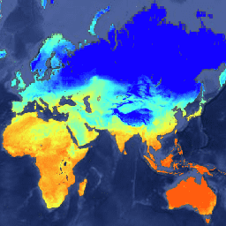
NASA Global Land Data Assimilation System Version 2 (GLDAS-2)에는 GLDAS-2.0, GLDAS-2.1, GLDAS-2.2의 세 가지 구성요소가 있습니다. GLDAS-2.0은 Princeton 기상 강제 입력 데이터로 완전히 강제 적용되며 1948년부터 2014년까지 시간적으로 일관된 시리즈를 제공합니다. GLDAS-2.1은 2000년부터의 모델 및 관측 데이터의 조합으로 강제됩니다.
[null,null,[],[[["\u003cp\u003eThe NASA Global Land Data Assimilation System (GLDAS-2.2) dataset provides 3-hourly land surface fields, including soil moisture, temperature, and evapotranspiration, from February 2003 to present.\u003c/p\u003e\n"],["\u003cp\u003eGLDAS-2.2 uses data assimilation, incorporating observations from the Gravity Recovery and Climate Experiment (GRACE) satellite, to estimate terrestrial water storage and related variables.\u003c/p\u003e\n"],["\u003cp\u003eThe dataset is available at a spatial resolution of 27830 meters and includes variables averaged, accumulated, and instantaneous over 3-hour intervals.\u003c/p\u003e\n"],["\u003cp\u003eGLDAS-2.2 is freely available through NASA's GES DISC and can be accessed and analyzed using Google Earth Engine.\u003c/p\u003e\n"],["\u003cp\u003eThis product is a component of the broader GLDAS-2 system, which also includes open-loop simulations (GLDAS-2.0 and GLDAS-2.1) covering earlier time periods.\u003c/p\u003e\n"]]],["The NASA GLDAS-2.2 dataset, provided by NASA GES DISC, offers daily land surface data from 2003-01-01 to 2024-11-30, simulated using the Catchment-F2.5 model with data assimilation. Key data includes 24 land surface fields, such as soil moisture, temperature, evaporation, and radiation, available with a 27830-meter pixel size. Data can be accessed via the Earth Engine using the provided code snippet. Data is free for research, education, and non-profit use.\n"],null,["# GLDAS-2.2: Global Land Data Assimilation System\n\nDataset Availability\n: 2003-01-01T03:00:00Z--2025-05-31T00:00:00Z\n\nDataset Provider\n:\n\n\n [NASA GES DISC at NASA Goddard Earth Sciences Data and Information Services Center](https://doi.org/10.5067/TXBMLX370XX8)\n\nCadence\n: 1 Day\n\nTags\n:\n[3-hourly](/earth-engine/datasets/tags/3-hourly) [climate](/earth-engine/datasets/tags/climate) [cryosphere](/earth-engine/datasets/tags/cryosphere) [evaporation](/earth-engine/datasets/tags/evaporation) [forcing](/earth-engine/datasets/tags/forcing) [geophysical](/earth-engine/datasets/tags/geophysical) [gldas](/earth-engine/datasets/tags/gldas) [humidity](/earth-engine/datasets/tags/humidity) [ldas](/earth-engine/datasets/tags/ldas) [nasa](/earth-engine/datasets/tags/nasa) [precipitation](/earth-engine/datasets/tags/precipitation) [pressure](/earth-engine/datasets/tags/pressure) [radiation](/earth-engine/datasets/tags/radiation) [soil](/earth-engine/datasets/tags/soil) [soil-moisture](/earth-engine/datasets/tags/soil-moisture) [surface](/earth-engine/datasets/tags/surface) [temperature](/earth-engine/datasets/tags/temperature) [water-vapor](/earth-engine/datasets/tags/water-vapor) [wind](/earth-engine/datasets/tags/wind) \n\n#### Description\n\nNASA Global Land Data Assimilation System Version 2 (GLDAS-2) has three\ncomponents: GLDAS-2.0, GLDAS-2.1, and GLDAS-2.2. GLDAS-2.0 is forced entirely\nwith the Princeton meteorological forcing input data and provides a temporally\nconsistent series from 1948 through 2014. GLDAS-2.1 is forced with a combination\nof model and observation data from 2000 to present. GLDAS-2.2 product suites use\ndata assimilation (DA), whereas the GLDAS-2.0 and GLDAS-2.1 products are\n\"open-loop\" (i.e., no data assimilation). The choice of forcing data, as well as\nDA observation source, variable, and scheme, vary for different GLDAS-2.2\nproducts.GLDAS-2.2 is new to the GES DISC archive and currently includes a main\nproduct from CLSM-F2.5 with Data Assimilation for the Gravity Recovery and\nClimate Experiment (GRACE-DA) from February 2003 to present. The GLDAS-2.2\ndata are available in two production streams: main and Early, only main one\nis ingested.\n\nThe GLDAS-2.2 GRACE-DA product was simulated with Catchment-F2.5 in Land\nInformation System (LIS) Version 7. The data product contains 24 land\nsurface fields from February 1, 2003 to present.\n\nThe simulation started on February 1, 2003 using the conditions from the\nGLDAS-2.0 Daily Catchment model simulation, forced with the meteorological\nanalysis fields from the operational European Centre for Medium-Range\nWeather Forecasts (ECMWF) Integrated Forecasting System. The total\nterrestrial water anomaly observation from GRACE satellite was assimilated\n(Li et al, 2019). Due to the data agreement with ECMWF, this GLDAS-2.2 daily\nproduct does not include the meteorological forcing fields.\n\nDocumentation:\n\n- [Readme](https://hydro1.gesdisc.eosdis.nasa.gov/data/GLDAS/GLDAS_CLSM025_DA1_D.2.2/doc/README_GLDAS2.pdf)\n\n- [How-to](https://disc.gsfc.nasa.gov/information/howto?tags=hydrology)\n\n- [GES DISC Hydrology Documentation](https://disc.gsfc.nasa.gov/information/documents?title=Hydrology%20Documentation)\n\nProvider's Note: the names with extension _tavg are variables\naveraged over the past 3-hours, the names with extension '_acc' are\nvariables accumulated over the past 3-hours, the names with extension\n'_inst' are instantaneous variables, and the names with '_f' are\nforcing variables.\n\n### Bands\n\n\n**Pixel Size**\n\n27830 meters\n\n**Bands**\n\n| Name | Units | Min | Max | Pixel Size | Description |\n|---------------------|-----------|-------------|------------|------------|-----------------------------------|\n| `ACond_tavg` | m/s | 0.000379\\* | 5.99291\\* | meters | Aerodynamic conductance |\n| `AvgSurfT_tavg` | K | 179.818\\* | 324.265\\* | meters | Average surface skin temperature |\n| `CanopInt_tavg` | kg/m\\^2 | 0\\* | 1.57295\\* | meters | Plant canopy surface water |\n| `ECanop_tavg` | kg/m\\^2/s | -0.021881\\* | 5.3e-05\\* | meters | Canopy water evaporation |\n| `ESoil_tavg` | kg/m\\^2/s | -0.003637\\* | 0.001172\\* | meters | Direct evaporation from bare soil |\n| `EvapSnow_tavg` | kg/m\\^2/s | -0.021057\\* | 0.000728\\* | meters | Snow Evaporation |\n| `Evap_tavg` | kg/m\\^2/s | -0.02737\\* | 0.00121\\* | meters | Evapotranspiration |\n| `GWS_tavg` | mm | 77.0153\\* | 3599.01\\* | meters | Ground water storage |\n| `Lwnet_tavg` | W/m\\^2 | -221.308\\* | 490.842\\* | meters | Net long-wave radiation flux |\n| `Qg_tavg` | W/m\\^2 | -344.072\\* | 174.036\\* | meters | Heat flux |\n| `Qh_tavg` | W/m\\^2 | -2851.75\\* | 54076.7\\* | meters | Sensible heat net flux |\n| `Qle_tavg` | W/m\\^2 | -53856.6\\* | 2983.65\\* | meters | Latent heat net flux |\n| `Qsb_tavg` | kg/m\\^2/s | 0\\* | 0.000416\\* | meters | Baseflow-groundwater runoff |\n| `Qsm_tavg` | kg/m\\^2/s | 0\\* | 0.018311\\* | meters | Snow melt |\n| `Qs_tavg` | kg/m\\^2/s | 0\\* | 0.020244\\* | meters | Storm surface runoff |\n| `SnowDepth_tavg` | m | 0\\* | 8.57951\\* | meters | Snow depth |\n| `SnowT_tavg` | K | 179.818\\* | 324.265\\* | meters | Snow Surface temperature |\n| `SoilMoist_P_tavg` | kg/m\\^2 | 109.394\\* | 4049.02\\* | meters | Profile Soil moisture |\n| `SoilMoist_RZ_tavg` | kg/m\\^2 | 32.3665\\* | 478.397\\* | meters | Root Zone Soil moisture |\n| `SoilMoist_S_tavg` | kg/m\\^2 | 0.001389\\* | 9.56\\* | meters | Surface Soil moisture |\n| `SWE_tavg` | kg/m\\^2 | 0\\* | 3688.07\\* | meters | Snow depth water equivalent |\n| `Swnet_tavg` | W/m\\^2 | 0\\* | 421.784\\* | meters | Net short wave radiation flux |\n| `TVeg_tavg` | kg/m\\^2/s | -0.000371\\* | 0.001654\\* | meters | Transpiration |\n| `TWS_tavg` | mm | 109.394\\* | 5084.16\\* | meters | Terrestrial water storage |\n\n\\* estimated min or max value\n\n### Image Properties\n\n**Image Properties**\n\n| Name | Type | Description |\n|------------|--------|-------------|\n| end_hour | DOUBLE | End hour |\n| start_hour | DOUBLE | Start hour |\n\n### Terms of Use\n\n**Terms of Use**\n\nDistribution of data from the Goddard Earth Sciences\nData and Information Services Center (GES DISC) is funded by NASA's\nScience Mission Directorate (SMD). Consistent with NASA [Earth\nScience Data and Information Policy](https://www.earthdata.nasa.gov/engage/open-data-services-and-software/data-and-information-policy/),\ndata from the GES DISC archive are available free to the user community.\nFor more information visit the GES DISC [Data Policy](https://disc.sci.gsfc.nasa.gov/citing)\npage.\n\n### Citations\n\nCitations:\n\n- Li, B., M. Rodell, S. Kumar, H. Beaudoing, A. Getirana, B. F. Zaitchik, et\n al. (2019) Global GRACE data assimilation for groundwater and drought\n monitoring: Advances and challenges. Water Resources Research, 55,\n 7564-7586.\n- [Additional references](https://ldas.gsfc.nasa.gov/gldas/GLDASpublications.php)\n\n### Explore with Earth Engine\n\n| **Important:** Earth Engine is a platform for petabyte-scale scientific analysis and visualization of geospatial datasets, both for public benefit and for business and government users. Earth Engine is free to use for research, education, and nonprofit use. To get started, please [register for Earth Engine access.](https://console.cloud.google.com/earth-engine)\n\n### Code Editor (JavaScript)\n\n```javascript\nvar dataset = ee.ImageCollection('NASA/GLDAS/V022/CLSM/G025/DA1D')\n .filter(ee.Filter.date('2010-06-01', '2010-06-02'));\nvar averageSurfaceSkinTemperatureK = dataset.select('AvgSurfT_tavg');\nvar averageSurfaceSkinTemperatureKVis = {\n min: 258,\n max: 316,\n palette: ['1303ff', '42fff6', 'f3ff40', 'ff5d0f'],\n};\nMap.setCenter(71.72, 52.48, 3.0);\nMap.addLayer(\n averageSurfaceSkinTemperatureK, averageSurfaceSkinTemperatureKVis,\n 'Average Surface Skin Temperature [K]');\n```\n[Open in Code Editor](https://code.earthengine.google.com/?scriptPath=Examples:Datasets/NASA/NASA_GLDAS_V022_CLSM_G025_DA1D) \n[GLDAS-2.2: Global Land Data Assimilation System](/earth-engine/datasets/catalog/NASA_GLDAS_V022_CLSM_G025_DA1D) \nNASA Global Land Data Assimilation System Version 2 (GLDAS-2) has three components: GLDAS-2.0, GLDAS-2.1, and GLDAS-2.2. GLDAS-2.0 is forced entirely with the Princeton meteorological forcing input data and provides a temporally consistent series from 1948 through 2014. GLDAS-2.1 is forced with a combination of model and observation data from 2000 ... \nNASA/GLDAS/V022/CLSM/G025/DA1D, 3-hourly,climate,cryosphere,evaporation,forcing,geophysical,gldas,humidity,ldas,nasa,precipitation,pressure,radiation,soil,soil-moisture,surface,temperature,water-vapor,wind \n2003-01-01T03:00:00Z/2025-05-31T00:00:00Z \n-90 -180 90 180 \nGoogle Earth Engine \nhttps://developers.google.com/earth-engine/datasets\n\n- [](https://doi.org/https://doi.org/10.5067/TXBMLX370XX8)\n- [](https://doi.org/https://developers.google.com/earth-engine/datasets/catalog/NASA_GLDAS_V022_CLSM_G025_DA1D)"]]