-
FLDAS: 기아 조기 경보 시스템 네트워크 (FEWS NET) 토지 데이터 동화 시스템
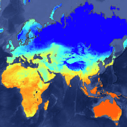
FLDAS 데이터 세트 (McNally et al. 2017)는 데이터가 부족한 개발도상국에서 식량 안보 평가를 지원하도록 설계되었습니다. FLDAS 데이터 세트에는 습도, 증발산, 평균 토양 온도, 총 강수량 등 다양한 기후 관련 변수에 관한 정보가 포함되어 있습니다. FLDAS 데이터 세트는 여러 가지가 있습니다. … 기후 cryosphere evapotranspiration humidity ldas monthly -
GLDAS-2.1: 글로벌 토지 데이터 동화 시스템
NASA 글로벌 지상 데이터 동화 시스템 버전 2 (GLDAS-2)에는 GLDAS-2.0, GLDAS-2.1, GLDAS-2.2라는 세 가지 구성요소가 있습니다. GLDAS-2.0은 프린스턴 기상 강제 입력 데이터로 완전히 강제되며 1948년부터 2014년까지 시간적으로 일관된 계열을 제공합니다. GLDAS-2.1은 모델 조합으로 강제됩니다. 3시간 간격 기후 cryosphere evaporation forcing geophysical -
GLDAS-2.2: 글로벌 토지 데이터 동화 시스템
NASA 글로벌 지상 데이터 동화 시스템 버전 2 (GLDAS-2)에는 GLDAS-2.0, GLDAS-2.1, GLDAS-2.2라는 세 가지 구성요소가 있습니다. GLDAS-2.0은 프린스턴 기상 강제 입력 데이터로 완전히 강제되며 1948년부터 2014년까지 시간적으로 일관된 계열을 제공합니다. GLDAS-2.1은 모델 조합으로 강제됩니다. 3시간 간격 기후 cryosphere evaporation forcing geophysical -
NLDAS-2: 북미 토지 데이터 동화 시스템 강제 필드
LDAS (Land Data Assimilation System)는 여러 관측 소스 (예: 강우량 측정기 데이터, 위성 데이터, 레이더 강우량 측정)를 결합하여 지구 표면 또는 그 근처의 기후학적 속성을 추정합니다. 이 데이터 세트는 … 단계의 기본 (기본값) 강제 파일 (파일 A)입니다. climate evaporation forcing geophysical hourly humidity -
재처리된 GLDAS-2.0: 글로벌 토지 데이터 동화 시스템
NASA 글로벌 지상 데이터 동화 시스템 버전 2 (GLDAS-2)에는 GLDAS-2.0, GLDAS-2.1, GLDAS-2.2라는 세 가지 구성요소가 있습니다. GLDAS-2.0은 프린스턴 기상 강제 입력 데이터로 완전히 강제되며 1948년부터 2014년까지 시간적으로 일관된 계열을 제공합니다. GLDAS-2.1은 모델 조합으로 강제됩니다. 3시간 간격 기후 cryosphere evaporation forcing geophysical
Datasets tagged ldas in Earth Engine
[null,null,[],[[["\u003cp\u003eThis collection provides access to various Land Data Assimilation System (LDAS) datasets, including FLDAS, GLDAS, and NLDAS.\u003c/p\u003e\n"],["\u003cp\u003eThese datasets offer insights into climate-related variables like moisture content, humidity, evapotranspiration, temperature, and precipitation.\u003c/p\u003e\n"],["\u003cp\u003eGLDAS datasets are available in different versions (GLDAS-2.0, GLDAS-2.1, and GLDAS-2.2) with varying temporal ranges and forcing data.\u003c/p\u003e\n"],["\u003cp\u003eFLDAS is specifically designed to support food security assessments, particularly in data-sparse regions.\u003c/p\u003e\n"],["\u003cp\u003eLDAS datasets combine observations from various sources to estimate climatological properties near the Earth's surface.\u003c/p\u003e\n"]]],[],null,["# Datasets tagged ldas in Earth Engine\n\n-\n\n |---------------------------------------------------------------------------------------------------------------------------------------------------------------------------------------------------------------------------------------------------------------------------------------------------------------------------------------------------------------------------|\n | [### FLDAS: Famine Early Warning Systems Network (FEWS NET) Land Data Assimilation System](/earth-engine/datasets/catalog/NASA_FLDAS_NOAH01_C_GL_M_V001) |\n | The FLDAS dataset (McNally et al. 2017), was designed to assist with food security assessments in data-sparse, developing country settings. It includes information on many climate-related variables including moisture content, humidity, evapotranspiration, average soil temperature, total precipitation rate, etc. There are multiple different FLDAS datasets; ... |\n | [climate](/earth-engine/datasets/tags/climate) [cryosphere](/earth-engine/datasets/tags/cryosphere) [evapotranspiration](/earth-engine/datasets/tags/evapotranspiration) [humidity](/earth-engine/datasets/tags/humidity) [ldas](/earth-engine/datasets/tags/ldas) [monthly](/earth-engine/datasets/tags/monthly) |\n\n-\n\n |------------------------------------------------------------------------------------------------------------------------------------------------------------------------------------------------------------------------------------------------------------------------------------------------------------------------------------|\n | [### GLDAS-2.1: Global Land Data Assimilation System](/earth-engine/datasets/catalog/NASA_GLDAS_V021_NOAH_G025_T3H) |\n | NASA Global Land Data Assimilation System Version 2 (GLDAS-2) has three components: GLDAS-2.0, GLDAS-2.1, and GLDAS-2.2. GLDAS-2.0 is forced entirely with the Princeton meteorological forcing input data and provides a temporally consistent series from 1948 through 2014. GLDAS-2.1 is forced with a combination of model ... |\n | [3-hourly](/earth-engine/datasets/tags/3-hourly) [climate](/earth-engine/datasets/tags/climate) [cryosphere](/earth-engine/datasets/tags/cryosphere) [evaporation](/earth-engine/datasets/tags/evaporation) [forcing](/earth-engine/datasets/tags/forcing) [geophysical](/earth-engine/datasets/tags/geophysical) |\n\n-\n\n |------------------------------------------------------------------------------------------------------------------------------------------------------------------------------------------------------------------------------------------------------------------------------------------------------------------------------------|\n | [### GLDAS-2.2: Global Land Data Assimilation System](/earth-engine/datasets/catalog/NASA_GLDAS_V022_CLSM_G025_DA1D) |\n | NASA Global Land Data Assimilation System Version 2 (GLDAS-2) has three components: GLDAS-2.0, GLDAS-2.1, and GLDAS-2.2. GLDAS-2.0 is forced entirely with the Princeton meteorological forcing input data and provides a temporally consistent series from 1948 through 2014. GLDAS-2.1 is forced with a combination of model ... |\n | [3-hourly](/earth-engine/datasets/tags/3-hourly) [climate](/earth-engine/datasets/tags/climate) [cryosphere](/earth-engine/datasets/tags/cryosphere) [evaporation](/earth-engine/datasets/tags/evaporation) [forcing](/earth-engine/datasets/tags/forcing) [geophysical](/earth-engine/datasets/tags/geophysical) |\n\n-\n\n |--------------------------------------------------------------------------------------------------------------------------------------------------------------------------------------------------------------------------------------------------------------------------------------------------------------------------------------|\n | [### NLDAS-2: North American Land Data Assimilation System Forcing Fields](/earth-engine/datasets/catalog/NASA_NLDAS_FORA0125_H002) |\n | Land Data Assimilation System (LDAS) combines multiple sources of observations (such as precipitation gauge data, satellite data, and radar precipitation measurements) to produce estimates of climatological properties at or near the Earth''s surface. This dataset is the primary (default) forcing file (File A) for Phase ... |\n | [climate](/earth-engine/datasets/tags/climate) [evaporation](/earth-engine/datasets/tags/evaporation) [forcing](/earth-engine/datasets/tags/forcing) [geophysical](/earth-engine/datasets/tags/geophysical) [hourly](/earth-engine/datasets/tags/hourly) [humidity](/earth-engine/datasets/tags/humidity) |\n\n-\n\n |------------------------------------------------------------------------------------------------------------------------------------------------------------------------------------------------------------------------------------------------------------------------------------------------------------------------------------|\n | [### Reprocessed GLDAS-2.0: Global Land Data Assimilation System](/earth-engine/datasets/catalog/NASA_GLDAS_V20_NOAH_G025_T3H) |\n | NASA Global Land Data Assimilation System Version 2 (GLDAS-2) has three components: GLDAS-2.0, GLDAS-2.1, and GLDAS-2.2. GLDAS-2.0 is forced entirely with the Princeton meteorological forcing input data and provides a temporally consistent series from 1948 through 2014. GLDAS-2.1 is forced with a combination of model ... |\n | [3-hourly](/earth-engine/datasets/tags/3-hourly) [climate](/earth-engine/datasets/tags/climate) [cryosphere](/earth-engine/datasets/tags/cryosphere) [evaporation](/earth-engine/datasets/tags/evaporation) [forcing](/earth-engine/datasets/tags/forcing) [geophysical](/earth-engine/datasets/tags/geophysical) |"]]