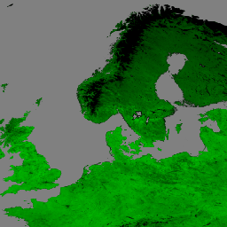
Suomi National Polar-Orbiting Partnership(S-NPP)NASA 可視赤外撮像機放射計(VIIRS)植生指数(VNP13A1)データ プロダクトは、500 メートルの解像度で 16 日間の取得期間に利用可能な最適なピクセルを選択するプロセスによって植生指数を提供します。VNP13 データ プロダクトは、中分解能撮像分光放射計(MODIS)Terra および Aqua 植生指数プロダクト スイートに準拠して設計されており、地球観測システム(EOS)ミッションの継続性を促進します。
VNP13 アルゴリズム プロセスでは、(1) 正規化植生指標(NDVI)、(2) 拡張植生指標(EVI)、(3) 拡張植生指標 2(EVI2)の 3 つの植生指標が生成されます。(1)NDVI は、赤色バンドと近赤外線(NIR)バンドの両方を使用して、最も長く継続的にリモート センシングされた時系列観測の一つです。(2)EVI は NDVI よりも樹冠被覆率に敏感な、わずかに異なる植生指数です。NDVI はクロロフィルに敏感です。(3)EVI2 は、赤色バンドと NIR バンドを使用して標準の 3 バンド EVI を再構成したものです。この再編成により、VIIRS EVI を青色バンドを含まない他の EVI モデルと比較する際に発生する問題に対処します。EVI2 は最終的に標準の EVI になります。
[null,null,[],[[["\u003cp\u003eThe NASA VIIRS VNP13A1 dataset provides vegetation indices (NDVI, EVI, EVI2) and reflectance data at 500m resolution over 16-day periods.\u003c/p\u003e\n"],["\u003cp\u003eThis dataset, available from 2012-01-17 to 2024-11-24, is designed for continuity with MODIS vegetation indices products.\u003c/p\u003e\n"],["\u003cp\u003eVNP13A1 includes quality assessment layers for pixel reliability, view and sun angles, and potential cloud or snow/ice presence.\u003c/p\u003e\n"],["\u003cp\u003eThe dataset is freely accessible through NASA LP DAAC and is easily integrated into Google Earth Engine for analysis.\u003c/p\u003e\n"],["\u003cp\u003eUsers are requested to cite the dataset appropriately in publications using data derived from this product.\u003c/p\u003e\n"]]],[],null,["Dataset Availability\n: 2012-01-17T00:00:00Z--2025-08-05T00:00:00Z\n\nDataset Provider\n:\n\n\n [NASA LP DAAC at the USGS EROS Center](https://doi.org/10.5067/VIIRS/VNP13A1.002)\n\nCadence\n: 8 Days\n\nTags\n:\n [16-day](/earth-engine/datasets/tags/16-day) [evi](/earth-engine/datasets/tags/evi) [nasa](/earth-engine/datasets/tags/nasa) [ndvi](/earth-engine/datasets/tags/ndvi) [noaa](/earth-engine/datasets/tags/noaa) [npp](/earth-engine/datasets/tags/npp) [vegetation](/earth-engine/datasets/tags/vegetation) [vegetation-indices](/earth-engine/datasets/tags/vegetation-indices) [viirs](/earth-engine/datasets/tags/viirs) \nvnp13a1 \n\nDescription \nThe Suomi National Polar-Orbiting Partnership (S-NPP) NASA Visible\nInfrared Imaging Radiometer Suite (VIIRS) Vegetation Indices (VNP13A1)\ndata product provides vegetation indices by a process of\nselecting the best available pixel over a 16-day acquisition period\nat 500 meter resolution. The VNP13 data products are designed\nafter the Moderate Resolution Imaging Spectroradiometer (MODIS)\nTerra and Aqua Vegetation Indices product suite to promote the\ncontinuity of the Earth Observation System (EOS) mission.\n\nThe VNP13 algorithm process produces three vegetation indices: (1)\nNormalized Difference Vegetation Index (NDVI), (2) the Enhanced\nVegetation Index (EVI), and (3) Enhanced Vegetation Index-2 (EVI2).\n(1) NDVI is one of the longest continual remotely sensed time series\nobservations, using both the red and near-infrared (NIR) bands.\n(2) EVI is a slightly different vegetation index that is more sensitive\nto canopy cover, while NDVI is more sensitive to chlorophyll. (3) EVI2\nis a reformation of the standard 3-band EVI, using the red band and\nNIR band. This reformation addresses arising issues when comparing\nVIIRS EVI to other EVI models that do not include a blue band. EVI2\nwill eventually become the standard EVI.\n\nAlong with the three Vegetation Indices layers, this product also\nincludes layers for near-infrared (NIR) reflectance; three shortwave\ninfrared (SWIR) reflectance-red, blue, and green reflectance; composite\nday of year; pixel reliability; view and sun angles, and a quality layer.\n\nFor additional information, visit the VIIRS [Land Product Quality\nAssessment website](https://landweb.modaps.eosdis.nasa.gov/browse?sensor=VIIRS&sat=SNPP) and see\nthe [User Guide](https://lpdaac.usgs.gov/documents/1372/VNP13_User_Guide_ATBD_V2.1.2.pdf).\n\nDocumentation:\n\n- [General Documentation](https://ladsweb.modaps.eosdis.nasa.gov/filespec/VIIRS/1/VNP13A1)\n\nBands\n\n\n**Pixel Size**\n\n500 meters\n\n**Bands**\n\n| Name | Units | Pixel Size | Wavelength | Description |\n|-----------------------------|-------|------------|-------------|--------------------------------------------|---|---|---|---|---|---|---|---|---|---|---|---|---|---|---|---|---|---|---|---|---|---|---|---|---|---|---|---|---|---|---|---|---|---|---|---|---|---|---|---|---|---|---|---|---|---|---|---|---|---|---|---|---|---|---|---|---|---|---|---|---|---|---|---|---|---|---|---|---|---|---|---|---|---|---|---|---|---|---|---|---|---|---|---|---|---|---|---|---|---|---|---|---|---|---|\n| `EVI` | | meters | None | 3 band Enhanced Vegetation Index |\n| `EVI2` | | meters | None | 2 band Enhanced Vegetation Index |\n| `NDVI` | | meters | None | Normalized Difference Vegetation Index |\n| `NIR_reflectance` | | meters | 846-885nm | Near-infrared Radiation reflectance |\n| `SWIR1_reflectance` | | meters | 1230-1250nm | Shortwave Infrared Radiation reflectance |\n| `SWIR2_reflectance` | | meters | 1580-1640nm | Shortwave Infrared Radiation reflectance |\n| `SWIR3_reflectance` | | meters | 2225-2275nm | Shortwave Infrared Radiation reflectance |\n| `VI_Quality` | | meters | None | Quality Assessment (QA) bit-field. |\n| Bitmask for VI_Quality - Bits 0-1: MODLAND_QA - 0: VI produced, good quality - 1: VI produced, but check other QA - 2: Pixel produced, but probably cloudy - 3: Pixel not produced due to other reason than clouds - Bits 2-5: VI Usefulness, higher values are worse. - 0: Highest Quality - 1: Lower quality - 2: Decreasing quality - 3: Decreasing quality - 4: Decreasing quality - 5: Decreasing quality - 6: Decreasing quality - 7: Decreasing quality - 8: Decreasing quality - 9: Decreasing quality - 10: Decreasing quality - 11: Decreasing quality - 12: Worst quality - 13: Quality so low that it is not useful - 14: L1B data faulty - 15: Not useful for any reason/not processed - Bits 6-7: Aerosol quantity - 0: Climatology - 1: Low - 2: Average - 3: High - Bit 8: Adjacent cloud detected - 0: No - 1: Yes - Bit 9: Adjacent BRDF correction performed - 0: No - 1: Yes - Bit 10: Mixed clouds - 0: No - 1: Yes - Bits 11-13: Land/Water Flag - 0: land \\& desert - 1: land no desert - 2: inland water - 3: sea_water - 5: coastal - Bit 14: Possible snow/ice - 0: No - 1: Yes - Bit 15: Possible shadow - 0: No - 1: Yes ||||||||||||||||||||||||||||||||||||||||||||||||||||||||||||||||||||||||||||||||||||||||||||||||||||\n| `red_reflectance` | | meters | 600-680nm | Red band reflectance |\n| `green_reflectance` | | meters | 545-656nm | Green band reflectance |\n| `blue_reflectance` | | meters | 478-498nm | Blue band reflectance |\n| `composite_day_of_the_year` | d | meters | None | Julian day of year |\n| `pixel_reliability` | | meters | None | Pixel usefulness using a simple rank class |\n| `relative_azimuth_angle` | deg | meters | None | Relative azimuth angle for each pixel |\n| `sun_zenith_angle` | deg | meters | None | Sun zenith angle for each pixel |\n| `view_zenith_angle` | deg | meters | None | View zenith angle for each pixel |\n\n**pixel_reliability Class Table**\n\n| Value | Color | Description |\n|-------|-------|-----------------------------|\n| 0 | None | Excellent |\n| 1 | None | Good |\n| 2 | None | Acceptable |\n| 3 | None | Marginal |\n| 4 | None | Pass |\n| 5 | None | Questionable |\n| 6 | None | Poor |\n| 7 | None | Cloud Shadow |\n| 8 | None | Snow/Ice |\n| 9 | None | Cloud |\n| 10 | None | Estimated |\n| 11 | None | LTAVG (taken from database) |\n\nTerms of Use\n\n**Terms of Use**\n\nLP DAAC NASA data are freely accessible; however, when an author\npublishes these data or works based on the data, it is requested that the\nauthor cite the datasets within the text of the publication and include a\nreference to them in the reference list.\n\nCitations \nCitations:\n\n- Please visit [LP DAAC 'Citing Our Data' page](https://lpdaac.usgs.gov/citing_our_data)\n for information on citing LP DAAC datasets.\n\nDOIs\n\n- \u003chttps://doi.org/10.5067/VIIRS/VNP13A1.002\u003e\n\nExplore with Earth Engine **Important:** Earth Engine is a platform for petabyte-scale scientific analysis and visualization of geospatial datasets, both for public benefit and for business and government users. Earth Engine is free to use for research, education, and nonprofit use. To get started, please [register for Earth Engine access.](https://console.cloud.google.com/earth-engine)\n\nCode Editor (JavaScript) \n\n```javascript\nvar dataset = ee.ImageCollection('NASA/VIIRS/002/VNP13A1')\n .filter(ee.Filter.date('2017-05-01', '2017-06-30'));\nvar rgb = dataset.select(['EVI']);\nvar rgbVis = {\n min: 0.0,\n max: 1.0,\n palette: ['000000', '004400', '008800', '00bb00', '00ff00'],\n};\nMap.setCenter(17.93, 7.71, 6);\nMap.addLayer(rgb, rgbVis, 'RGB');\n```\n[Open in Code Editor](https://code.earthengine.google.com/?scriptPath=Examples:Datasets/NASA/NASA_VIIRS_002_VNP13A1) \n[VNP13A1.002: VIIRS Vegetation Indices 16-Day 500m](/earth-engine/datasets/catalog/NASA_VIIRS_002_VNP13A1) \nThe Suomi National Polar-Orbiting Partnership (S-NPP) NASA Visible Infrared Imaging Radiometer Suite (VIIRS) Vegetation Indices (VNP13A1) data product provides vegetation indices by a process of selecting the best available pixel over a 16-day acquisition period at 500 meter resolution. The VNP13 data products are designed after the Moderate Resolution Imaging ... \nNASA/VIIRS/002/VNP13A1, 16-day,evi,nasa,ndvi,noaa,npp,vegetation,vegetation-indices,viirs \n2012-01-17T00:00:00Z/2025-08-05T00:00:00Z \n-90 -180 90 180 \nGoogle Earth Engine \nhttps://developers.google.com/earth-engine/datasets\n\n- [https://doi.org/10.5067/VIIRS/VNP13A1.002](https://doi.org/https://doi.org/10.5067/VIIRS/VNP13A1.002)\n- [https://doi.org/10.5067/VIIRS/VNP13A1.002](https://doi.org/https://developers.google.com/earth-engine/datasets/catalog/NASA_VIIRS_002_VNP13A1)"]]