Page Summary
-
The NOAA Optimum Interpolation Sea Surface Temperature (OISST) dataset provides daily ocean temperature fields on a global grid.
-
The dataset is constructed using bias-adjusted observations from satellites (primarily AVHRR), ships, and buoys, with gaps filled by interpolation.
-
Data is available from September 1, 1981, and updated daily with both near real-time and final versions.
-
The dataset includes bands for sea surface temperature, temperature anomaly, sea ice concentration, and estimated error.
-
This dataset is publicly available with no restrictions on use, following U.S. open data policies.
- Dataset Availability
- 1981-09-01T00:00:00Z–2026-07-20T00:00:00Z
- Dataset Producer
- NOAA
- Cadence
- 1 Day
- Tags
Description
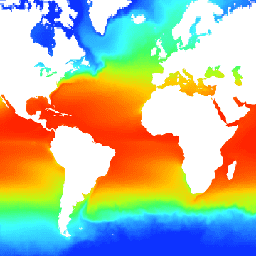
The NOAA 1/4 degree daily Optimum Interpolation Sea Surface Temperature (OISST) provides complete ocean temperature fields constructed by combining bias-adjusted observations from different platforms (satellite, ships, buoys) on a regular global grid, with gaps filled in by interpolation. Satellite data from the Advanced Very High Resolution Radiometer (AVHRR) provides the main input which permits the high temporal-spatial coverage beginning in late 1981 to the present.
The OISST dataset has a single day's data processed twice. First a near real-time preliminary version is released with a lag of 1 day, and a final version with a lag of 14 days. The final version uses extra days for smoothing, and zonal bias correction in addition to replacing the preliminary version.
Bands
Bands
Pixel size: 27830 meters (all bands)
| Name | Units | Min | Max | Scale | Pixel Size | Description |
|---|---|---|---|---|---|---|
sst |
°C | -180* | 3764* | 0.01 | 27830 meters | Daily sea surface temperature |
anom |
°C | -1887* | 1902* | 0.01 | 27830 meters | Temperature anomaly; the daily OISST minus a 30-year climatological mean. |
ice |
% | 1* | 100* | 0.01 | 27830 meters | Seven-day median of daily sea ice concentrations. |
err |
°C | 11* | 171* | 0.01 | 27830 meters | Estimated error; standard deviation of analyzed sea surface temperature. |
Image Properties
Image Properties
| Name | Type | Description |
|---|---|---|
| status | STRING | 'provisional' or 'permanent' |
Terms of Use
Terms of Use
The NOAA CDR Program's official distribution point for CDRs is NOAA's National Climatic Data Center which provides sustained, open access and active data management of the CDR packages and related information in keeping with the United States' open data policies and practices as described in the President's Memorandum on "Open Data Policy" and pursuant to the Executive Order of May 9, 2013, "Making Open and Machine Readable the New Default for Government Information". In line with these policies, the CDR data sets are nonproprietary, publicly available, and no restrictions are placed upon their use. For more information, see the Fair Use of NOAA's CDR Data Sets, Algorithms and Documentation pdf.
Citations
Richard W. Reynolds, Viva F. Banzon, and NOAA CDR Program (2008): NOAA Optimum Interpolation 1/4 Degree Daily Sea Surface Temperature (OISST) Analysis, Version 2. [indicate subset used]. NOAA National Centers for Environmental Information. doi:10.7289/V5SQ8XB5 [access date].
DOIs
Explore with Earth Engine
Code Editor (JavaScript)
var dataset = ee.ImageCollection('NOAA/CDR/OISST/V2_1')
                  .filter(ee.Filter.date('2017-05-01', '2017-05-14'));
var seaSurfaceTemperature = dataset.select('sst');
var visParams = {
  min: -180.0,
  max: 3000.0,
  palette: [
    '040274', '040281', '0502a3', '0502b8', '0502ce', '0502e6',
    '0602ff', '235cb1', '307ef3', '269db1', '30c8e2', '32d3ef',
    '3be285', '3ff38f', '86e26f', '3ae237', 'b5e22e', 'd6e21f',
    'fff705', 'ffd611', 'ffb613', 'ff8b13', 'ff6e08', 'ff500d',
    'ff0000', 'de0101', 'c21301', 'a71001', '911003'
  ],
};
Map.setCenter(20.3, -20.39, 2);
Map.addLayer(seaSurfaceTemperature, visParams, 'Sea Surface Temperature');