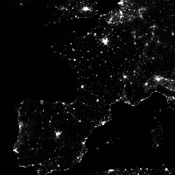
가시광선 적외선 이미징 방사계 스위트 (VIIRS) 주간/야간 밴드 (DNB)의 야간 데이터를 사용하는 월별 평균 복사 휘도 합성 이미지입니다.
이러한 데이터는 매월 합성되므로 해당 월에 양질의 데이터 범위를 확보할 수 없는 지역이 전 세계에 많이 있습니다.
이는 특히 열대 지역에서 구름이 덮여 있거나 각 극지방의 여름철에 태양 조명으로 인해 발생할 수 있습니다. 따라서 이러한 데이터를 사용하는 사용자는 평균 복사 휘도 이미지에서 값이 0이라고 관찰된 조명이 없다고 가정하지 말고 'cf_cvg' 대역을 사용하는 것이 좋습니다.
구름량은 VIIRS Cloud Mask 제품 (VCM)을 사용하여 결정됩니다. 또한 스와스의 가장자리 근처에 있는 데이터는 컴포지트에 포함되지 않습니다 (집계 영역 29~32). 버전 1은 오로라, 불, 보트, 기타 일시적인 조명에서 나오는 빛을 차단하도록 필터링되지 않았습니다. 이 분리는 개발 중이며 이 시계열의 향후 버전에 포함될 예정입니다. 또한 빛을 배경 (빛이 아닌) 값과 분리하는 방법도 개발 중입니다.
이 제품은 미광을 보정하는 절차를 사용하여 VIIRS DNB를 대체 구성한 것입니다. 보정 절차는 보이는 영역을 극에 더 가깝게 확장하고 다이내믹 레인지를 개선합니다. 일부 아티팩트는 황혼 지역에서 사용되는 절차로 인해 도입됩니다. 자세한 내용은 참고 논문을 참고하세요. 이 제품은 구름으로 인해 영향을 받는 데이터를 제외합니다.
대역
픽셀 크기 463.83미터
대역
이름
단위
최소
최대
픽셀 크기
설명
avg_rad
nanoWatts/sr/cm^2
-1.5*
193565*
미터
평균 DNB 복사 휘도 값입니다.
cf_cvg
0*
84*
미터
구름이 없는 커버리지입니다. 각 픽셀에 사용된 총 관측 횟수입니다. 이 대역은 품질이 저하된 관측 횟수가 적은 영역을 식별하는 데 사용할 수 있습니다.
* 예상 최솟값 또는 최댓값
이용약관
이용약관
콜로라도 광산 대학의 데이터, 정보, 제품은 전달 방법에 관계없이 저작권의 적용을 받지 않으며 일반인의 후속 사용에 제한이 없습니다. 획득한 후에는 합법적인 용도로 사용할 수 있습니다. 위의 데이터는 퍼블릭 도메인에 속하며 사용 및 배포에 제한 없이 제공됩니다.
가시광선 적외선 이미징 방사계 스위트 (VIIRS) 주간/야간 대역 (DNB)의 야간 데이터를 사용하는 월별 평균 복사 휘도 합성 이미지입니다. 이러한 데이터는 매월 합성되므로 해당 월에 양질의 데이터 범위를 확보할 수 없는 지역이 전 세계에 많이 있습니다. 이러한 문제는 다음과 같은 이유로 발생할 수 있습니다.
[null,null,[],[[["\u003cp\u003eThe dataset provides monthly average radiance composite images using nighttime data from the Visible Infrared Imaging Radiometer Suite (VIIRS) Day/Night Band (DNB).\u003c/p\u003e\n"],["\u003cp\u003eIt includes a stray light correction procedure that extends visible areas closer to the poles and improves dynamic range, but may introduce artifacts in twilight regions.\u003c/p\u003e\n"],["\u003cp\u003eUsers should utilize the 'cf_cvg' band to identify areas with potential low-quality data due to cloud cover or solar illumination.\u003c/p\u003e\n"],["\u003cp\u003eThe dataset has not been filtered to screen out lights from aurora, fires, boats, and other temporal lights, which will be addressed in a later version.\u003c/p\u003e\n"],["\u003cp\u003eThe data is provided by the Colorado School of Mines and is in the public domain, free for any lawful use without restriction.\u003c/p\u003e\n"]]],["The dataset provides monthly average radiance composite images from the VIIRS Day/Night Band (DNB), spanning January 1, 2014, to October 1, 2024. It utilizes nighttime data corrected for stray light and excludes cloud-covered areas. Users are advised to check the 'cf_cvg' band for data quality due to potential cloud cover or solar illumination issues. The data, provided by the Colorado School of Mines, is available without usage restrictions and can be accessed via Earth Engine using the provided snippet and code. The images contain the average DNB radiance values and cloud-free coverage.\n"],null,["# VIIRS Stray Light Corrected Nighttime Day/Night Band Composites Version 1\n\nDataset Availability\n: 2014-01-01T00:00:00Z--2025-03-01T00:00:00Z\n\nDataset Provider\n:\n\n\n [Earth Observation Group, Payne Institute for Public Policy, Colorado School of Mines](https://eogdata.mines.edu/products/vnl/#monthly)\n\nCadence\n: 1 Month\n\nTags\n:\n [dnb](/earth-engine/datasets/tags/dnb) [eog](/earth-engine/datasets/tags/eog) [lights](/earth-engine/datasets/tags/lights) [monthly](/earth-engine/datasets/tags/monthly) [nighttime](/earth-engine/datasets/tags/nighttime) [noaa](/earth-engine/datasets/tags/noaa) [population](/earth-engine/datasets/tags/population) [viirs](/earth-engine/datasets/tags/viirs) [visible](/earth-engine/datasets/tags/visible) \nstray-light \n\n#### Description\n\nMonthly average radiance composite images using nighttime data from the\nVisible Infrared Imaging Radiometer Suite (VIIRS) Day/Night Band (DNB).\n\nAs these data are composited monthly, there are many areas of the globe\nwhere it is impossible to get good quality data coverage for that month.\nThis can be due to cloud cover, especially in the tropical regions, or due\nto solar illumination, as happens toward the poles in their respective\nsummer months. Therefore it is recommended that users of these data utilize\nthe 'cf_cvg' band and not assume a value of zero in the average radiance\nimage means that no lights were observed.\n\nCloud cover is determined using the VIIRS Cloud\nMask product (VCM). In addition, data near the edges of the swath are not\nincluded in the composites (aggregation zones 29-32). Version 1 has NOT\nbeen filtered to screen out lights from aurora, fires, boats, and other\ntemporal lights. This separation is under development and will be included\nin a later version of this time series. Also in development is a method to\nseparate lights from background (non-light) values.\n\nThis product is an alternative configuration of the VIIRS DNB using a\nprocedure to correct for stray light. The correction procedure extends\nvisible areas closer to the poles and improves dynamic range. It should be\nnoted some artifacts are introduced due to the procedure used in twilight\nregions; see\n[reference paper](https://spie.org/Publications/Proceedings/Paper/10.1117/12.2023107)\nfor more details. This product excludes data\nimpacted by cloud cover.\n\n### Bands\n\n\n**Pixel Size**\n\n463.83 meters\n\n**Bands**\n\n| Name | Units | Min | Max | Pixel Size | Description |\n|-----------|--------------------|--------|----------|------------|------------------------------------------------------------------------------------------------------------------------------------------------------------------------------------------|\n| `avg_rad` | nanoWatts/sr/cm\\^2 | -1.5\\* | 193565\\* | meters | Average DNB radiance values. |\n| `cf_cvg` | | 0\\* | 84\\* | meters | Cloud-free coverages; the total number of observations that went into each pixel. This band can be used to identify areas with low numbers of observations where the quality is reduced. |\n\n\\* estimated min or max value\n\n### Terms of Use\n\n**Terms of Use**\n\nColorado School of Mines data, information, and products,\nregardless of the method of delivery,\nare not subject to copyright and carry no restrictions on their subsequent\nuse by the public. Once obtained, they may be put to any lawful use. The\nforgoing data is in the public domain and is being provided without\nrestriction on use and distribution.\n\n### Explore with Earth Engine\n\n| **Important:** Earth Engine is a platform for petabyte-scale scientific analysis and visualization of geospatial datasets, both for public benefit and for business and government users. Earth Engine is free to use for research, education, and nonprofit use. To get started, please [register for Earth Engine access.](https://console.cloud.google.com/earth-engine)\n\n### Code Editor (JavaScript)\n\n```javascript\nvar dataset = ee.ImageCollection('NOAA/VIIRS/DNB/MONTHLY_V1/VCMSLCFG')\n .filter(ee.Filter.date('2017-05-01', '2017-05-31'));\nvar nighttime = dataset.select('avg_rad');\nvar nighttimeVis = {min: 0.0, max: 60.0};\nMap.setCenter(-77.1056, 38.8904, 8);\nMap.addLayer(nighttime, nighttimeVis, 'Nighttime');\n```\n[Open in Code Editor](https://code.earthengine.google.com/?scriptPath=Examples:Datasets/NOAA/NOAA_VIIRS_DNB_MONTHLY_V1_VCMSLCFG) \n[VIIRS Stray Light Corrected Nighttime Day/Night Band Composites Version 1](/earth-engine/datasets/catalog/NOAA_VIIRS_DNB_MONTHLY_V1_VCMSLCFG) \nMonthly average radiance composite images using nighttime data from the Visible Infrared Imaging Radiometer Suite (VIIRS) Day/Night Band (DNB). As these data are composited monthly, there are many areas of the globe where it is impossible to get good quality data coverage for that month. This can be due to ... \nNOAA/VIIRS/DNB/MONTHLY_V1/VCMSLCFG, dnb,eog,lights,monthly,nighttime,noaa,population,viirs,visible \n2014-01-01T00:00:00Z/2025-03-01T00:00:00Z \n-65 -180 75 180 \nGoogle Earth Engine \nhttps://developers.google.com/earth-engine/datasets\n\n- [](https://doi.org/https://eogdata.mines.edu/products/vnl/#monthly)\n- [](https://doi.org/https://developers.google.com/earth-engine/datasets/catalog/NOAA_VIIRS_DNB_MONTHLY_V1_VCMSLCFG)"]]