This dataset provides complete land ice and ocean
classification masks at 15 m for the Greenland ice sheet.
Ice cover was mapped using
a combination of orthorectified panchromatic (band 8)
imagery from the Landsat 7 Enhanced Thematic Mapper
Plus (ETM+), distributed by the USGS, and RADARSAT-1
Synthetic Amplitude Radar (SAR) amplitude images produced
and distributed by I. Joughin at the Applied Physics
Laboratory, University of Washington.
The Landsat imagery was acquired for the months of July
through September in 1999, 2000 and 2001 (mostly 2000)
and the RADARSAT imagery was acquired in fall of 2000.
Bands
Pixel Size 15 meters
Bands
Name
Pixel Size
Description
ocean_mask
meters
Ocean mask
ice_mask
meters
Ice mask
ocean_mask Class Table
Value
Color
Description
0
#000000
all other terrain
1
#0000ff
ocean
ice_mask Class Table
Value
Color
Description
0
#000000
not glacier ice
1
#ffffff
glacier ice
Terms of Use
Terms of Use
As a condition of using these data, you must cite the use of this
data set using the given citation.
Citations
Citations:
Howat, I.M., A. Negrete, B.E. Smith, 2014, The Greenland Ice
Mapping Project (GIMP) land classification and surface elevation
datasets, The Cryosphere, 8, 1509-1518,
doi:10.5194/tc-8-1509-2014article pdf
This dataset provides complete land ice and ocean classification masks at 15 m for the Greenland ice sheet. Ice cover was mapped using a combination of orthorectified panchromatic (band 8) imagery from the Landsat 7 Enhanced Thematic Mapper Plus (ETM+), distributed by the USGS, and RADARSAT-1 Synthetic Amplitude Radar (SAR) …
[null,null,[],[[["\u003cp\u003e
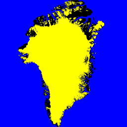
This dataset provides 15m resolution land ice and ocean classification masks for the Greenland ice sheet.\u003c/p\u003e\n"],["\u003cp\u003eIt utilizes Landsat 7 ETM+ and RADARSAT-1 SAR imagery primarily acquired between 1999 and 2001.\u003c/p\u003e\n"],["\u003cp\u003eThe dataset includes two bands: \u003ccode\u003eocean_mask\u003c/code\u003e and \u003ccode\u003eice_mask\u003c/code\u003e, identifying ocean and glacier ice respectively.\u003c/p\u003e\n"],["\u003cp\u003eUsers must cite the provided sources when using this dataset, including the Howat et al.(2014) publication.\u003c/p\u003e\n"]]],["The dataset provides 15-meter resolution land ice and ocean classification masks for the Greenland ice sheet, using Landsat 7 ETM+ imagery from July-September (1999-2001) and RADARSAT-1 SAR imagery from fall 2000. It includes `ocean_mask` (0 for other terrain, 1 for ocean) and `ice_mask` (0 for no glacier ice, 1 for glacier ice). Data is available from June 30, 1999, to September 4, 2002, with provider NASA NSIDC DAAC. Access is provided through Google Earth Engine.\n"],null,["# Greenland Ice & Ocean Mask - Greenland Mapping Project (GIMP)\n\nDataset Availability\n: 1999-06-30T00:00:00Z--2002-09-04T00:00:00Z\n\nDataset Provider\n:\n\n\n [NASA NSIDC DAAC at CIRES](https://doi.org/10.5067/B8X58MQBFUPA)\n\nTags\n:\n [arctic](/earth-engine/datasets/tags/arctic) [cryosphere](/earth-engine/datasets/tags/cryosphere) [gimp](/earth-engine/datasets/tags/gimp) [greenland](/earth-engine/datasets/tags/greenland) [ice](/earth-engine/datasets/tags/ice) [nasa](/earth-engine/datasets/tags/nasa) [polar](/earth-engine/datasets/tags/polar) \nmask \n\n#### Description\n\nThis dataset provides complete land ice and ocean\nclassification masks at 15 m for the Greenland ice sheet.\nIce cover was mapped using\na combination of orthorectified panchromatic (band 8)\nimagery from the Landsat 7 Enhanced Thematic Mapper\nPlus (ETM+), distributed by the USGS, and RADARSAT-1\nSynthetic Amplitude Radar (SAR) amplitude images produced\nand distributed by I. Joughin at the Applied Physics\nLaboratory, University of Washington.\n\nThe Landsat imagery was acquired for the months of July\nthrough September in 1999, 2000 and 2001 (mostly 2000)\nand the RADARSAT imagery was acquired in fall of 2000.\n\n### Bands\n\n\n**Pixel Size**\n\n15 meters\n\n**Bands**\n\n| Name | Pixel Size | Description |\n|--------------|------------|-------------|\n| `ocean_mask` | meters | Ocean mask |\n| `ice_mask` | meters | Ice mask |\n\n**ocean_mask Class Table**\n\n| Value | Color | Description |\n|-------|---------|-------------------|\n| 0 | #000000 | all other terrain |\n| 1 | #0000ff | ocean |\n\n**ice_mask Class Table**\n\n| Value | Color | Description |\n|-------|---------|-----------------|\n| 0 | #000000 | not glacier ice |\n| 1 | #ffffff | glacier ice |\n\n### Terms of Use\n\n**Terms of Use**\n\nAs a condition of using these data, you must cite the use of this\ndata set using the given citation.\n\n### Citations\n\nCitations:\n\n- Howat, I.M., A. Negrete, B.E. Smith, 2014, The Greenland Ice\n Mapping Project (GIMP) land classification and surface elevation\n datasets, The Cryosphere, 8, 1509-1518,\n [doi:10.5194/tc-8-1509-2014](https://doi.org/10.5194/tc-8-1509-2014)\n [article pdf](https://www.the-cryosphere.net/8/1509/2014/tc-8-1509-2014.pdf)\n\n### DOIs\n\n- \u003chttps://doi.org/10.5067/B8X58MQBFUPA\u003e\n\n### Explore with Earth Engine\n\n| **Important:** Earth Engine is a platform for petabyte-scale scientific analysis and visualization of geospatial datasets, both for public benefit and for business and government users. Earth Engine is free to use for research, education, and nonprofit use. To get started, please [register for Earth Engine access.](https://console.cloud.google.com/earth-engine)\n\n### Code Editor (JavaScript)\n\n```javascript\nvar dataset = ee.Image('OSU/GIMP/2000_ICE_OCEAN_MASK');\nvar oceanAndIceMaskVis = {\n min: 0.0,\n max: 1.0,\n bands: ['ice_mask', 'ice_mask', 'ocean_mask'],\n};\nMap.setCenter(-41.0, 74.0, 4);\nMap.addLayer(dataset, oceanAndIceMaskVis, 'Ocean and Ice Mask');\n```\n[Open in Code Editor](https://code.earthengine.google.com/?scriptPath=Examples:Datasets/OSU/OSU_GIMP_2000_ICE_OCEAN_MASK) \n[Greenland Ice \\& Ocean Mask - Greenland Mapping Project (GIMP)](/earth-engine/datasets/catalog/OSU_GIMP_2000_ICE_OCEAN_MASK) \nThis dataset provides complete land ice and ocean classification masks at 15 m for the Greenland ice sheet. Ice cover was mapped using a combination of orthorectified panchromatic (band 8) imagery from the Landsat 7 Enhanced Thematic Mapper Plus (ETM+), distributed by the USGS, and RADARSAT-1 Synthetic Amplitude Radar (SAR) ... \nOSU/GIMP/2000_ICE_OCEAN_MASK, arctic,cryosphere,gimp,greenland,ice,nasa,polar \n1999-06-30T00:00:00Z/2002-09-04T00:00:00Z \n58.79601275381146 -89.3211593425295 83.95386175580668 7.555941634834938 \nGoogle Earth Engine \nhttps://developers.google.com/earth-engine/datasets\n\n- [https://doi.org/10.5067/B8X58MQBFUPA](https://doi.org/https://doi.org/10.5067/B8X58MQBFUPA)\n- [https://doi.org/10.5067/B8X58MQBFUPA](https://doi.org/https://developers.google.com/earth-engine/datasets/catalog/OSU_GIMP_2000_ICE_OCEAN_MASK)"]]