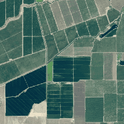
미국 농업 이미지 프로그램 (NAIP)은 미국 본토의 농업 성장기에 항공 이미지를 획득합니다.
NAIP 프로젝트는 사용 가능한 자금과 이미지 획득 주기에 따라 매년 계약됩니다. 2003년부터 NAIP는 5년 주기로 획득되었습니다. 2008년은 전환기였으며 2009년에 3년 주기가 시작되었습니다.
NAIP 이미지는 이미지 검사 중에 사용되는 사진 식별 가능 지상 제어점의 6미터 이내에 일치하는 수평 정확도로 1미터 지상 샘플 거리 (GSD)에서 획득됩니다.
이전 이미지는 3개 밴드 (빨간색, 녹색, 파란색: RGB)를 사용하여 수집되었지만 최신 이미지는 일반적으로 추가 근적외선 밴드(RGBN)를 사용하여 수집됩니다. RGB 애셋 ID는 'n'으로 시작하고, NRG 애셋 ID는 'c'으로 시작하며, RGBN 애셋 ID는 'm_'으로 시작합니다.
일부 이전 이미지의 GSD는 2미터입니다.
대역
픽셀 크기 0.6미터
대역
이름
단위
픽셀 크기
설명
R
dn
미터
빨간색
G
dn
미터
초록색
B
dn
미터
파란색
N
dn
미터
근적외선
이용약관
이용약관
FSA 웹사이트에 표시된 대부분의 정보는 퍼블릭 도메인 정보로 간주됩니다. 퍼블릭 도메인 정보는 자유롭게 배포하거나 복사할 수 있지만 적절한 이름/사진/이미지 출처를 사용하는 것이 좋습니다. 자세한 내용은 FSA 정책 및 링크 웹사이트를 참고하세요.
이 데이터 세트를 사용하거나 배포할 때는 USDA 농장 생산 및 보존 - 비즈니스 센터, 지리 공간 엔터프라이즈 운영을 인용해야 합니다.
[null,null,[],[[["\u003cp\u003eThe National Agriculture Imagery Program (NAIP) provides high-resolution aerial imagery of the continental U.S. during agricultural growing seasons.\u003c/p\u003e\n"],["\u003cp\u003eImagery is acquired at a one-meter ground sample distance (GSD) with a horizontal accuracy within six meters of ground control points.\u003c/p\u003e\n"],["\u003cp\u003eNAIP imagery is available from 2002 to 2023 and includes 3-band (RGB) and 4-band (RGBN) options, with some older images having a 2-meter GSD.\u003c/p\u003e\n"],["\u003cp\u003eThe dataset is provided by the USDA Farm Production and Conservation - Business Center, Geospatial Enterprise Operations, and is considered public domain information.\u003c/p\u003e\n"],["\u003cp\u003eUsers can access and analyze NAIP imagery using the Google Earth Engine platform.\u003c/p\u003e\n"]]],[],null,["# NAIP: National Agriculture Imagery Program\n\nDataset Availability\n: 2002-06-15T00:00:00Z--2023-11-17T00:00:00Z\n\nDataset Provider\n:\n\n\n [USDA Farm Production and Conservation - Business Center, Geospatial Enterprise Operations](https://naip-usdaonline.hub.arcgis.com/)\n\nTags\n:\n [agriculture](/earth-engine/datasets/tags/agriculture) [highres](/earth-engine/datasets/tags/highres) [imagery](/earth-engine/datasets/tags/imagery) [orthophotos](/earth-engine/datasets/tags/orthophotos) [usda](/earth-engine/datasets/tags/usda) \n aerial \n fpac \nnaip \n\n#### Description\n\nThe National Agriculture Imagery Program (NAIP) acquires aerial imagery\nduring the agricultural growing seasons in the continental U.S.\n\nNAIP projects are contracted each year based upon available funding and the\nimagery acquisition cycle. Beginning in 2003, NAIP was acquired on\na 5-year cycle. 2008 was a transition year, and a three-year cycle began\nin 2009.\n\nNAIP imagery is acquired at a one-meter ground sample distance (GSD) with a\nhorizontal accuracy that matches within six meters of photo-identifiable\nground control points, which are used during image inspection.\n\nOlder images were collected using 3 bands (Red, Green, and Blue: RGB), but\nnewer imagery is usually collected with an additional near-infrared band\n(RGBN). RGB asset ids begin with 'n*', NRG asset ids begin with 'c*', RGBN\nasset ids begin with 'm_'.\n\nSome older images have GSD of 2 meters.\n\n### Bands\n\n\n**Pixel Size**\n\n0.6 meters\n\n**Bands**\n\n| Name | Units | Pixel Size | Description |\n|------|-------|------------|---------------|\n| `R` | dn | meters | Red |\n| `G` | dn | meters | Green |\n| `B` | dn | meters | Blue |\n| `N` | dn | meters | Near infrared |\n\n### Terms of Use\n\n**Terms of Use**\n\nMost information presented on the FSA Web site is considered public domain\ninformation. Public domain information may be freely distributed or copied,\nbut use of appropriate byline/photo/image credits is requested. For more\ninformation visit the\n[FSA Policies and Links](https://www.fsa.usda.gov/help/policies-and-links)\nwebsite.\n\nUsers should acknowledge USDA Farm Production and Conservation -\nBusiness Center, Geospatial Enterprise Operations when using or\ndistributing this data set.\n\n### Citations\n\nCitations:\n\n- USDA Farm Production and Conservation - Business Center, Geospatial Enterprise Operations\n\n### Explore with Earth Engine\n\n| **Important:** Earth Engine is a platform for petabyte-scale scientific analysis and visualization of geospatial datasets, both for public benefit and for business and government users. Earth Engine is free to use for research, education, and nonprofit use. To get started, please [register for Earth Engine access.](https://console.cloud.google.com/earth-engine)\n\n### Code Editor (JavaScript)\n\n```javascript\nvar dataset = ee.ImageCollection('USDA/NAIP/DOQQ')\n .filter(ee.Filter.date('2017-01-01', '2018-12-31'));\nvar trueColor = dataset.select(['R', 'G', 'B']);\nvar trueColorVis = {\n min: 0,\n max: 255,\n};\nMap.setCenter(-73.9958, 40.7278, 15);\nMap.addLayer(trueColor, trueColorVis, 'True Color');\n```\n[Open in Code Editor](https://code.earthengine.google.com/?scriptPath=Examples:Datasets/USDA/USDA_NAIP_DOQQ) \n[NAIP: National Agriculture Imagery Program](/earth-engine/datasets/catalog/USDA_NAIP_DOQQ) \nThe National Agriculture Imagery Program (NAIP) acquires aerial imagery during the agricultural growing seasons in the continental U.S. NAIP projects are contracted each year based upon available funding and the imagery acquisition cycle. Beginning in 2003, NAIP was acquired on a 5-year cycle. 2008 was a transition year, and a ... \nUSDA/NAIP/DOQQ, agriculture,highres,imagery,orthophotos,usda \n2002-06-15T00:00:00Z/2023-11-17T00:00:00Z \n24.42 -124.84 49.72 -64.82 \nGoogle Earth Engine \nhttps://developers.google.com/earth-engine/datasets\n\n- [](https://doi.org/https://naip-usdaonline.hub.arcgis.com/)\n- [](https://doi.org/https://developers.google.com/earth-engine/datasets/catalog/USDA_NAIP_DOQQ)"]]