- 데이터 세트 사용 가능 기간
- 1998-08-16T00:00:00Z–2020-05-06T00:00:00Z
- 데이터 세트 제공업체
- United States Geological Survey
- 태그
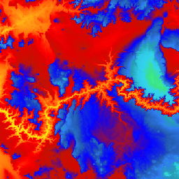
설명
미국을 위한 원활한 3DEP DEM 데이터 세트이며, 48개의 인접한 주, 하와이, 미국 영토를 완전히 포함합니다. 알래스카 지역은 현재 부분적으로 제공되며, 알래스카 지도 제작 이니셔티브의 일환으로 주 전역으로 확대될 예정입니다. 지상 간격은 남북으로 약 10m이지만, 위도에 따른 자오선의 수렴으로 인해 동서로 가변적입니다.
1m 데이터세트는 USGS_3DEP_1m으로 인제스트됩니다.
Farmers Business Network에서 업로드한 데이터 세트입니다.
대역
대역
| 이름 | 단위 | 픽셀 크기 | 설명 |
|---|---|---|---|
elevation |
m | 10.2미터 | 고도 |
이용약관
이용약관
대부분의 미국 지질조사국 (USGS) 정보는 퍼블릭 도메인에 있으며 제한 없이 사용할 수 있습니다. 정보 소스로 USGS를 인용 또는 표시에 관한 추가 정보를 확인할 수 있습니다.
인용
인용:
U.S. Geological Survey, 3D Elevation Program 10-Meter Resolution Digital Elevation Model.
Earth Engine으로 탐색하기
코드 편집기(JavaScript)
var dataset = ee.ImageCollection('USGS/3DEP/10m_collection')
var elevation = dataset.select('elevation');

Map.setCenter(-112.8598, 36.2841, 7);
Map.addLayer(elevation, {min: 0, max: 3000,   palette: [
    '3ae237', 'b5e22e', 'd6e21f', 'fff705', 'ffd611', 'ffb613', 'ff8b13',
    'ff6e08', 'ff500d', 'ff0000', 'de0101', 'c21301', '0602ff', '235cb1',
    '307ef3', '269db1', '30c8e2', '32d3ef', '3be285', '3ff38f', '86e26f'
  ],
}, 'elevation');