WRI 참고: WRI는 FORMA 알림 업데이트를 중단하기로 결정했습니다. 목표는 Global Forest Watch 사용자 환경을 간소화하고 중복을 줄이는 것이었습니다.
Terra-i와 GLAD가 더 자주 사용되는 것으로 확인되었습니다.
또한 GLAD를 표준으로 사용하여 Terra-i가 전 세계적으로 FORMA보다 성능이 우수함을 확인했습니다.
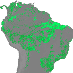
FORMA 알림은 NDVI (정규 식생 지수)와 FIRMS(자원 관리 시스템용 화재 정보)라는 두 가지 MODIS 제품을 조합하여 감지됩니다. NDVI 업데이트는 16일마다 처리되고 화재 업데이트는 매일 처리됩니다. 모델은 각 생태 그룹에 대해 개별적으로 개발되어 두 입력을 벌채 지역과 연결하며, Hansen 연간 나무 덮개 손실 데이터를 사용하여 모델을 학습시킵니다. 경고로 간주되는 최소 기준점은 픽셀의 25% 가 지워진 경우입니다. 하지만 오탐을 최소화하기 위해 기준점은 ecogroup에 따라 다릅니다.
다음은 FORMA 데이터 세트를 간략하게 소개하는 예시 스크립트입니다.
이 ImageCollection의 이미지는 새로운 MODIS FIRMS 데이터를 사용할 수 있게 된 후 계산된 원시 FORMA 데이터를 포함하며, 이는 거의 매일 발생합니다.
각 대역은 다양한 누적 기간에 대한 소거 비율 (0~100)을 나타냅니다. 'N'은 최신 FIRMS 업데이트와 이전 NDVI 업데이트 사이의 일수입니다. N은 'date_delta' 속성으로 제공됩니다.
대역
픽셀 크기 250미터
대역
이름
단위
최소
최대
픽셀 크기
설명
nday
%
0
100
미터
지난 N일 동안의 결제 비율
delta_nday
%
0
100
미터
지난 96+N일 동안의 결제 비율
near_term_delta_nday
%
0
100
미터
지난 32+N일 동안의 결제 비율
이미지 속성
이미지 속성
이름
유형
설명
년
INT
데이터 세트에 포함된 가장 최근 데이터의 연도
날짜
문자열
이 데이터 세트에 포함된 마지막 MODIS FIRMS 데이터의 날짜입니다('YYYY-MM-DD' 형식).
date_delta
INT
날짜와 previous_biweekly_date 사이의 일수
previous_biweekly
INT
최신 MODIS NDVI와 관련된 연도의 격주 (16일마다) 기간
previous_biweekly_date
문자열
최신 MODIS NDVI 업데이트와 관련된 날짜
이용약관
이용약관
FORMA 데이터 세트는 사용 또는 배포에 제한이 없습니다. WRI는 사용자가 적절한 저작자 표시를 제공하고 해당되는 경우 WRI와 GFW를 데이터 소스로 식별하도록 요청합니다.
WRI 참고: WRI는 FORMA 알림 업데이트를 중단하기로 결정했습니다. 목표는 Global Forest Watch 사용자 환경을 간소화하고 중복을 줄이는 것이었습니다. Terra-i와 GLAD가 더 자주 사용되는 것으로 확인되었습니다. 또한 GLAD를 표준으로 사용하여 Terra-i가 전 세계적으로 FORMA보다 성능이 우수함을 확인했습니다. FORMA 알림이 감지됨 …
[null,null,[],[[["\u003cp\u003eThe FORMA dataset provides daily near real-time deforestation alerts, derived from MODIS NDVI and FIRMS data, by showing the percentage of forest clearing within different time periods.\u003c/p\u003e\n"],["\u003cp\u003eWRI has discontinued updating FORMA alerts, recommending Terra-i and GLAD as preferred alternatives due to higher usage and performance.\u003c/p\u003e\n"],["\u003cp\u003eFORMA alerts are triggered when the clearing threshold reaches 25% of a pixel, but this threshold varies across different ecological groups to minimize false positives.\u003c/p\u003e\n"],["\u003cp\u003eThe dataset offers bands representing the percentage of clearing within the last N days, the last 96+N days, and the last 32+N days, where N represents the days between the latest FIRMS and previous NDVI updates.\u003c/p\u003e\n"],["\u003cp\u003eWhile no longer updated, the FORMA dataset remains available for use and distribution with proper attribution to WRI and GFW.\u003c/p\u003e\n"]]],[],null,["# FORMA Raw Output FIRMS\n\nDataset Availability\n: 2017-04-08T00:00:00Z--2019-05-18T00:00:00Z\n\nDataset Provider\n:\n\n\n [World Resources Institute / Global Forest Watch](https://www.globalforestwatch.org/)\n\nTags\n:\n[daily](/earth-engine/datasets/tags/daily) [deforestation](/earth-engine/datasets/tags/deforestation) [fire](/earth-engine/datasets/tags/fire) [forest](/earth-engine/datasets/tags/forest) [forma](/earth-engine/datasets/tags/forma) [gfw](/earth-engine/datasets/tags/gfw) [modis](/earth-engine/datasets/tags/modis) [monitoring](/earth-engine/datasets/tags/monitoring) [wri](/earth-engine/datasets/tags/wri) \n\n#### Description\n\n**NOTE from WRI** : WRI decided to stop updating FORMA alerts. The goal was\nto simplify the [Global Forest Watch](https://www.globalforestwatch.org)\nuser experience and reduce redundancy.\nWe found that [Terra-i](http://www.terra-i.org/terra-i.html) and\n[GLAD](https://glad-forest-alert.appspot.com/) were more frequently used.\nMoreover, using GLAD as a standard, found that Terra-i outperformed\nFORMA globally.\n\nFORMA alerts are detected using a combination of two MODIS\nproducts: NDVI (Normalized Difference Vegetation Index) and FIRMS\n(Fires Information for Resource Management System). NDVI updates are\nprocessed every 16 days, while fire updates are processed daily. Models\nare developed individually for each ecogroup to relate the two inputs to\nthe area of clearing, using the Hansen annual tree cover loss data to train\nthe model. The minimum threshold to qualify as an alert is 25% of the pixel\ncleared, though thresholds vary by ecogroup to minimize false positives.\nHere is an [example script](https://code.earthengine.google.com/f29b1e4360f3fc36847bd789ceeb20f6)\nfor a quick introduction to the FORMA datasets.\n\nThe images in this ImageCollection contain the raw FORMA data calculated after new\nMODIS FIRMS data becomes available, approximately every day.\n\nEach band gives a percentage of clearing (from 0 to 100) for\ndifferent accumulation periods. \"N\" is the number of days between the latest FIRMS update\nand the previous NDVI update. N is given by the 'date_delta' property.\n\n### Bands\n\n\n**Pixel Size**\n\n250 meters\n\n**Bands**\n\n| Name | Units | Min | Max | Pixel Size | Description |\n|------------------------|-------|-----|-----|------------|----------------------------------------------|\n| `nday` | % | 0 | 100 | meters | Percentage of clearing in the last N days |\n| `delta_nday` | % | 0 | 100 | meters | Percentage of clearing in the last 96+N days |\n| `near_term_delta_nday` | % | 0 | 100 | meters | Percentage of clearing in the last 32+N days |\n\n### Image Properties\n\n**Image Properties**\n\n| Name | Type | Description |\n|------------------------|--------|---------------------------------------------------------------------------------------|\n| year | INT | Year of the most recent data included in the dataset |\n| date | STRING | Date, in \"YYYY-MM-DD\" format, of the last MODIS FIRMS data included in this dataset |\n| date_delta | INT | The number of days between date and previous_biweekly_date |\n| previous_biweekly | INT | The biweekly (every 16 days) period of the year associated with the latest MODIS NDVI |\n| previous_biweekly_date | STRING | The date associated with the latest MODIS NDVI update |\n\n### Terms of Use\n\n**Terms of Use**\n\nThe FORMA datasets are available without restriction\non use or distribution. WRI does request that the\nuser give proper attribution and identify WRI and GFW, where applicable,\nas the source of the data.\n\n### Explore with Earth Engine\n\n| **Important:** Earth Engine is a platform for petabyte-scale scientific analysis and visualization of geospatial datasets, both for public benefit and for business and government users. Earth Engine is free to use for research, education, and nonprofit use. To get started, please [register for Earth Engine access.](https://console.cloud.google.com/earth-engine)\n\n### Code Editor (JavaScript)\n\n```javascript\nvar dataset = ee.ImageCollection('WRI/GFW/FORMA/raw_output_firms')\n .filter(ee.Filter.date('2018-08-01', '2018-08-15'));\nvar percentageOfClearing = dataset.select('nday');\nvar visParams = {\n min: 0.0,\n max: 0.01,\n};\nMap.setCenter(26, -8, 3);\nMap.addLayer(percentageOfClearing, visParams, 'Percentage of clearing');\n```\n[Open in Code Editor](https://code.earthengine.google.com/?scriptPath=Examples:Datasets/WRI/WRI_GFW_FORMA_raw_output_firms) \n[FORMA Raw Output FIRMS](/earth-engine/datasets/catalog/WRI_GFW_FORMA_raw_output_firms) \nNOTE from WRI: WRI decided to stop updating FORMA alerts. The goal was to simplify the Global Forest Watch user experience and reduce redundancy. We found that Terra-i and GLAD were more frequently used. Moreover, using GLAD as a standard, found that Terra-i outperformed FORMA globally. FORMA alerts are detected ... \nWRI/GFW/FORMA/raw_output_firms, daily,deforestation,fire,forest,forma,gfw,modis,monitoring,wri \n2017-04-08T00:00:00Z/2019-05-18T00:00:00Z \n-50 -120 40 180 \nGoogle Earth Engine \nhttps://developers.google.com/earth-engine/datasets\n\n- [](https://doi.org/https://www.globalforestwatch.org/)\n- [](https://doi.org/https://developers.google.com/earth-engine/datasets/catalog/WRI_GFW_FORMA_raw_output_firms)"]]