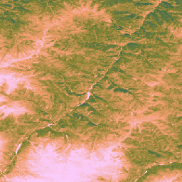
이 데이터 세트는 2000년부터 30m 공간 해상도로 관측한 전 세계 보정되지 않은 EO 기반 총 일차 생산량을 제공합니다.
Land & Carbon Lab Global Pasture Watch 이니셔티브에서 제작한 현재 데이터 세트는 2000년부터 30m 공간 해상도로 전 세계의 총 일차 생산량 (GPP) 값을 제공합니다.
GPP 값은 경량 사용 효율성 (LUE) 접근 방식을 통해 모델링됩니다. 여기서 GLAD Landsat ARD (컬렉션 2)는 2개월마다 집계됩니다(Consoli 외, 2024년)와 결합하고 1km MODIS 온도 데이터와 1° CERES 광합성 활성 방사선 (PAR)을 결합했습니다.
데이터 세트의 유연성을 유지하기 위해 최대 광 이용 효율 (LUEmax)은 모든 토지 피복 유형에 대해 1gC/m²/day/MJ로 설정되어 사용자가 나중에 특정 토지 피복 지도 또는 지역 조건에 따라 GPP 값을 보정할 수 있습니다.
2개월마다 보정되지 않은 총 기본 생산성 (uGPP) 값 (OpenLandMap STAC에서 사용 가능)은 연도별로 평균을 내고 전체 365일 기간에 걸쳐 누적되어 gC/m²/year 단위로 표현되는 전 세계 연간 uGPP 값을 생성합니다.
입력 데이터 해상도 불일치: 데이터 세트는 30m 해상도로 제공되지만 온도 (MOD11A1) 및 광합성 활성 방사 (CERES PAR)의 주요 입력 변수는 훨씬 더 거친 제품 (각각 1km 및 ~111km)에서 파생되었습니다.
이 정보를 다운스케일링하면 불확실성이 발생할 수 있으며 식물 생산성에 영향을 미치는 미세한 미기후 조건을 포착하지 못할 수 있습니다.
데이터 아티팩트: 데이터 세트에는 일부 영역의 세로 줄무늬 ('줄무늬 효과')를 비롯한 알려진 시각적 아티팩트가 포함되어 있습니다. 이는 Landsat 7 센서 (스캔 라인 수정기 오류)의 문제와 기본 반사율 보관 파일을 만드는 데 사용된 후속 간격 채우기 프로세스 (Consoli et al., 2024). 이러한 아티팩트는 흐린 날씨와 눈 덮임 기간 동안 GPP 추정치의 공간 연속성을 방해할 수 있습니다.
시간 해상도: 데이터는 격월 시간 해상도로 생성됩니다. 이 기간은 주요 성장 기간이나 환경 변화에 대한 식물의 빠른 반응 (강우량)을 포착하기에 충분하지 않을 수 있으므로 생산성 최고치와 계절적 변화를 정확하게 포착하기가 어렵습니다.
초지 보정: 초지 GPP 값은 MOD17 알고리즘을 기반으로 모든 전 세계 초지에 단일 최대 광 이용 효율 (LUEmax) 매개변수 (0.86gC/m²/year/MJ)를 사용하여 계산됩니다. 이 값은 특정 초원 유형이나 지역 조건에 최적화되어 있지 않습니다. 따라서 모델은 지상 기반 플럭스 타워 측정과 비교할 때 GPP를 과소평가하는 경향을 보입니다.
초원 지도 정확도에 대한 의존성: 초원 GPP 값의 정확도는 기본 GPW 초원 지도의 정확도에 따라 달라집니다.
소스 지도에서 토지 피복이 잘못 분류되면 (예: 관목지 또는 농경지가 초지로 식별됨) 해당 위치의 GPP 추정치에 상응하는 오류가 발생합니다.
Isik, M. S., Mesquita, V., Parente, L., & Consoli, D. (2025).
Global Pasture Watch - 30m에서 전역 보정되지 않은 EO 기반 GPP 및 초지 GPP 지도의 소스 코드입니다. Zenodo
[소스 코드]. Zenodo
doi:https://doi.org/10.5281/zenodo.15675358
Isik MS, Parente L, Consoli D, et al. (2025).
Light use efficiency (LUE) based bimonthly gross primary
productivity (GPP) for global grasslands at 30 m spatial
resolution (2000–2022), PeerJ.
doi: https://doi.org/10.7717/peerj.19774
이 데이터 세트는 2000년부터 30m 공간 해상도로 제공되는 전 세계 보정되지 않은 EO 기반 총 일차 생산량을 제공합니다. Land & Carbon Lab Global Pasture Watch 이니셔티브에서 제작한 현재 데이터 세트는 2000년부터 30m 공간 해상도로 전 세계의 총 일차 생산량 (GPP) 값을 제공합니다. GPP 값은 가벼운 사용을 통해 모델링됩니다.
[null,null,[],[],[],null,["# GPW Annual uncalibrated Gross Primary Productivity (uGPP) v1\n\ninfo\n\n\nThis dataset is part of a Publisher Catalog, and not managed by Google Earth Engine.\n\nContact [Land \\& Carbon Lab](https://landcarbonlab.org/subscribe)\n\nfor bugs or [view more datasets](https://developers.google.com/earth-engine/datasets/publisher/global-pasture-watch)\nfrom the Global Pasture Watch Catalog. [Learn more about Publisher datasets](/earth-engine/datasets/publisher). \n[](https://landcarbonlab.org/data/global-grassland-and-livestock-monitoring) \n\nCatalog Owner\n: Global Pasture Watch\n\nDataset Availability\n: 2000-01-01T00:00:00Z--2024-01-01T00:00:00Z\n\nDataset Provider\n:\n\n\n [Land and Carbon Lab Global Pasture Watch](https://landcarbonlab.org/data/global-grassland-and-livestock-monitoring)\n\nContact\n: [Land \\& Carbon Lab](https://landcarbonlab.org/subscribe)\n\nCadence\n: 1 Year\n\nTags\n:\n[global](/earth-engine/datasets/tags/global) [global-pasture-watch](/earth-engine/datasets/tags/global-pasture-watch) [land](/earth-engine/datasets/tags/land) [landcover](/earth-engine/datasets/tags/landcover) [landuse](/earth-engine/datasets/tags/landuse) [plant-productivity](/earth-engine/datasets/tags/plant-productivity) [publisher-dataset](/earth-engine/datasets/tags/publisher-dataset) [vegetation](/earth-engine/datasets/tags/vegetation) \n\n#### Description\n\nThis dataset provides global uncalibrated EO-based Gross Primary Productivity\nfrom 2000 at 30-m spatial resolution.\nProduced by Land \\& Carbon Lab Global Pasture Watch initiative, the current dataset provides\nGross Primary Productivity (GPP) values globally at 30-m spatial resolution from 2000 onwards.\nGPP values are modeled via a **light use efficiency (LUE)** approach,\nwhere [**GLAD Landsat ARD** (collection-2)](https://glad.umd.edu/ard/home) are aggregated every two months\n([Consoli et al., 2024](https://peerj.com/articles/18585/)) and combined with 1-km **MODIS\ntemperature** data and 1° **CERES Photosynthetically Active Radiation** (PAR).\n\nTo keep the dataset flexible, the maximum light use efficiency (LUEmax) is set to 1 gC/m²/day/MJ\nfor **all land cover types**, allowing the users to later calibrate the\nGPP values according to specific land cover maps or regional conditions.\n\n**Bi-monthly uncalibrated Gross Primary Productivity (uGPP)** values (available in [OpenLandMap STAC](https://stac.openlandmap.org/gpw_ugpp.daily-30m/collection.json)) are averaged by each year and accumulated over the full 365-day period to produce\nglobal annual uGPP values, expressed in units of gC/m²/year.\n\n**Grassland GPP** values are computed on-the-fly using [GEE App](https://global-pasture-watch.projects.earthengine.app/view/ggpp-30m).\n\n**Limitations:**\n\n- **Input data resolution mismatch**: The dataset is provided at 30 m resolution, but key input variables for temperature (MOD11A1)\n and photosynthetically active radiation (CERES PAR) were derived from much coarser products (1 km and \\~111 km, respectively).\n The downscaling of this information can introduce uncertainty and may not capture fine-scale microclimatic conditions affecting plant productivity.\n\n- **Data artifacts** : The dataset contains known visual artifacts, including vertical stripes (\"stripe effect\") in some areas, which are a result\n of issues with the Landsat 7 sensor (Scan Line Corrector failure) and the subsequent gap-filling process used to create the underlying\n reflectance archive ([Consoli et al., 2024](https://peerj.com/articles/18585/)). These artifacts can disrupt the spatial continuity\n of GPP estimates during cloudy and snow cover periods\n\n- **Temporal resolution**: The data is produced at a bimonthly temporal resolution. This timeframe may not be sufficient\n to capture key growth periods or a plant's rapid responses (intense rainfall) to environmental changes, making\n it difficult to accurately capture productivity peaks and seasonal variation.\n\n- **Grassland calibration**: Grassland GPP values are calculated using a single maximum light use efficiency (LUEmax)\n parameter (0.86 gC/m²/year/MJ) for all global grasslands, based on the MOD17 algorithm. This value is not optimized\n for specific grassland types or local conditions. As a result, the model shows a tendency to underestimate GPP when\n compared to ground-based flux tower measurements.\n\n- **Dependence on grassland maps accuracy** : The accuracy of the grassland GPP values is contingent on the accuracy of the\n underlying [GPW grassland maps](https://developers.google.com/earth-engine/datasets/catalog/projects_global-pasture-watch_assets_ggc-30m_v1_grassland_c).\n Any misclassification of land cover in the source maps (e.g., shrublands or croplands identified as grassland) will\n lead to corresponding errors in the GPP estimates for those locations.\n\n**For more information see [Isik et. al, 2025](https://doi.org/10.7717/peerj.19774),\n[Zenodo](https://doi.org/10.5281/zenodo.15675358) and\n[Global Pasture Watch GitHub site](https://github.com/wri/global-pasture-watch)**\n\n### Bands\n\n**Bands**\n\n| Name | Min | Max | Pixel Size | Description |\n|---------|-----|------|------------|--------------------------------------------------------|\n| `gc_m2` | 0 | 4000 | 30 meters | Grams of carbon per square meter per year (gC/m²/year) |\n\n### Image Properties\n\n**Image Properties**\n\n| Name | Type | Description |\n|---------|------|-----------------|\n| version | INT | Product version |\n\n### Terms of Use\n\n**Terms of Use**\n\n[CC-BY-4.0](https://spdx.org/licenses/CC-BY-4.0.html)\n\n### Citations\n\nCitations:\n\n- Isik, M. S., Mesquita, V., Parente, L., \\& Consoli, D. (2025).\n Global Pasture Watch - Source Code of the Global Uncalibrated EO-based GPP and\n Grassland GPP Maps at 30m. Zenodo.\n \\[Source code\\]. Zenodo\n [doi:https://doi.org/10.5281/zenodo.15675358](https://doi.org/10.5281/zenodo.15675358)\n- Isik MS, Parente L, Consoli D, et al. (2025).\n Light use efficiency (LUE) based bimonthly gross primary\n productivity (GPP) for global grasslands at 30 m spatial\n resolution (2000--2022), PeerJ.\n [doi: https://doi.org/10.7717/peerj.19774](https://doi.org/10.7717/peerj.19774)\n\n### DOIs\n\n- \u003chttps://doi.org/10.5281/zenodo.13890401\u003e\n- \u003chttps://doi.org/10.7717/peerj.19774\u003e\n\n### Explore with Earth Engine\n\n| **Important:** Earth Engine is a platform for petabyte-scale scientific analysis and visualization of geospatial datasets, both for public benefit and for business and government users. Earth Engine is free to use for research, education, and nonprofit use. To get started, please [register for Earth Engine access.](https://console.cloud.google.com/earth-engine)\n\n### Code Editor (JavaScript)\n\n```javascript\nMap.setCenter(-49.265188, -16.602052, 4);\n\nvar ugppVis = {min: 0, max: 4000, palette: \"faccfa,f19d6b,828232,226061,011959\"}\nvar ugpp = ee.ImageCollection(\n \"projects/global-pasture-watch/assets/ggpp-30m/v1/ugpp_m\"\n)\n\nvar ugpp2024 = ugpp.filterDate('2024-01-01', '2025-01-01').first();\nMap.addLayer(ugpp2024, ugppVis, 'Uncalibrated GPP (2024)');\n\nvar ugpp2000 = ugpp.filterDate('2000-01-01', '2001-01-01').first();\nMap.addLayer(ugpp2000, ugppVis, 'Uncalibrated GPP (2000)');\n```\n[Open in Code Editor](https://code.earthengine.google.com/?scriptPath=Examples:Datasets/global-pasture-watch/projects_global-pasture-watch_assets_ggpp-30m_v1_ugpp_m) \n[GPW Annual uncalibrated Gross Primary Productivity (uGPP) v1](/earth-engine/datasets/catalog/projects_global-pasture-watch_assets_ggpp-30m_v1_ugpp_m) \nThis dataset provides global uncalibrated EO-based Gross Primary Productivity from 2000 at 30-m spatial resolution. Produced by Land \\& Carbon Lab Global Pasture Watch initiative, the current dataset provides Gross Primary Productivity (GPP) values globally at 30-m spatial resolution from 2000 onwards. GPP values are modeled via a light use ... \nprojects/global-pasture-watch/assets/ggpp-30m/v1/ugpp_m, global,global-pasture-watch,land,landcover,landuse,plant-productivity,publisher-dataset,vegetation \n2000-01-01T00:00:00Z/2024-01-01T00:00:00Z \n-90 -180 90 180 \nGoogle Earth Engine \nhttps://developers.google.com/earth-engine/datasets\n\n- [https://doi.org/10.7717/peerj.19774](https://doi.org/https://landcarbonlab.org/data/global-grassland-and-livestock-monitoring)\n- [https://doi.org/10.7717/peerj.19774](https://doi.org/https://developers.google.com/earth-engine/datasets/catalog/projects_global-pasture-watch_assets_ggpp-30m_v1_ugpp_m)"]]