-
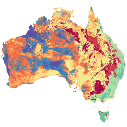
오스트레일리아의 실제 증발산량 (CMRSET Landsat V2.2)
이 데이터 세트는 CMRSET 알고리즘을 사용하여 오스트레일리아의 정확한 실제 증발산량 (AET 또는 ETa)을 제공합니다. AET 밴드 (이름: 'ETa')에는 해당 월의 모든 클라우드가 없는 Landsat 관측에 대한 CMRSET 모델의 평균 일일 값이 포함됩니다 (AET 데이터에서 값 3으로 표시됨). 농업 오스트레일리아 CSIRO 증발 증발산 랜드샛 파생 -
오스트레일리아 5M DEM
LiDAR 모델에서 파생된 오스트레일리아의 디지털 표고 모델 (DEM) 5미터 그리드는 2001년부터 2015년 사이에 245,000제곱킬로미터가 넘는 면적을 대상으로 실시된 약 236건의 개별 LiDAR 측정에서 파생된 국가 5미터 (지형지물 노출) DEM을 나타냅니다. … 오스트레일리아 dem elevation elevation-topography ga geophysical -
DEM-H: 오스트레일리아 SRTM 수문학적 적용 디지털 고도 모델
수문학적 적용 디지털 표고 모델 (DEM-H)은 2000년 2월 NASA에서 획득한 SRTM 데이터에서 파생되었습니다. 모델에 수문학적 조건이 적용되고 배수가 시행되었습니다. DEM-H는 SRTM 고도 및 매핑된 유로선을 기반으로 흐름 경로를 캡처하고 … 오스트레일리아 dem elevation elevation-topography ga geophysical -
DEM-S: 오스트레일리아의 보간된 디지털 고도 모델
평면화된 디지털 고도 모델 (DEM-S)은 2000년 2월에 NASA에서 획득한 SRTM 데이터에서 파생되었습니다. DEM-S는 지상 표면 지형지물 (식생 지형지물 제외)을 나타내며 노이즈를 줄이고 표면 도형의 표현을 개선하기 위해 평면화되었습니다. 적응형 프로세스는 더 많은 … 오스트레일리아 dem elevation elevation-topography ga geophysical -
국가 간조 디지털 표고 모델 25m 1.0.0 미리보기
국가 간조 디지털 고도 모델 (NIDEM, Bishop-Taylor 외 2018, 2019)은 오스트레일리아의 노출된 간조 지역에 대한 대륙 규모의 고도 데이터 세트입니다. NIDEM은 25m 깊이에서 오스트레일리아의 조간대 모래 해변과 해안, 갯벌, 암석 해안, 암초를 처음으로 3차원으로 … australia dem elevation-topography ga -
SLGA: 오스트레일리아의 토양 및 경관 그리드 (토양 속성)
오스트레일리아의 토양 및 경관 그리드 (SLGA)는 오스트레일리아 전역의 토양 속성을 3초 (~90m픽셀) 해상도로 포괄적으로 보여주는 데이터 세트입니다. 표면은 기존 토양 데이터와 환경 데이터를 사용하여 토양 속성의 공간적 분포를 설명하는 모델링의 결과입니다. 오스트레일리아 CSIRO soil tern
Datasets tagged australia in Earth Engine
[null,null,[],[[["\u003cp\u003eThis collection provides access to a variety of geospatial datasets focusing on Australia, including elevation models, land cover classifications, and water observations.\u003c/p\u003e\n"],["\u003cp\u003eDatasets are derived from various sources like LiDAR, SRTM, Landsat, and CMRSET, offering different resolutions and temporal coverage.\u003c/p\u003e\n"],["\u003cp\u003eGeoscience Australia and CSIRO are key providers of data, enabling analysis of Australia's terrain, soil, and water resources.\u003c/p\u003e\n"],["\u003cp\u003eDEA products offer insights into long-term environmental changes and conditions by leveraging extensive satellite imagery archives.\u003c/p\u003e\n"],["\u003cp\u003eUsers can explore Australia's intertidal zones through NIDEM, a detailed elevation model, and soil properties through SLGA, a comprehensive soil attribute dataset.\u003c/p\u003e\n"]]],["Several datasets provide detailed geographic and environmental information about Australia. Digital Elevation Models (DEMs) include a 5-meter grid from LiDAR surveys, a hydrologically enforced model, and a smoothed model from SRTM data, as well as a national intertidal DEM. Additional data includes the Soil and Landscape Grid of Australia (SLGA) with soil attributes. Landsat data is processed to show actual evapotranspiration (AET), land cover, water observations, and statistical analysis.\n"],null,["# Datasets tagged australia in Earth Engine\n\n-\n\n |-------------------------------------------------------------------------------------------------------------------------------------------------------------------------------------------------------------------------------------------------------------------------------------------------------------------------------------------------|\n | [### Actual Evapotranspiration for Australia (CMRSET Landsat V2.2)](/earth-engine/datasets/catalog/TERN_AET_CMRSET_LANDSAT_V2_2) |\n | This dataset provides accurate actual evapotranspiration (AET or ETa) for Australia using the CMRSET algorithm. The AET band (named 'ETa') contains the average daily value from the CMRSET model for all cloud-free Landsat observations in that month (indicated with value 3 in the AET Data ... |\n | [agriculture](/earth-engine/datasets/tags/agriculture) [australia](/earth-engine/datasets/tags/australia) [csiro](/earth-engine/datasets/tags/csiro) [evaporation](/earth-engine/datasets/tags/evaporation) [evapotranspiration](/earth-engine/datasets/tags/evapotranspiration) [landsat-derived](/earth-engine/datasets/tags/landsat-derived) |\n\n-\n\n |-------------------------------------------------------------------------------------------------------------------------------------------------------------------------------------------------------------------------------------------------------------------------------------------------------------------|\n | [### Australian 5M DEM](/earth-engine/datasets/catalog/AU_GA_AUSTRALIA_5M_DEM) |\n | The Digital Elevation Model (DEM) 5 meter Grid of Australia derived from LiDAR model represents a National 5 meter (bare earth) DEM which has been derived from some 236 individual LiDAR surveys between 2001 and 2015 covering an area in excess of 245,000 square kilometers. ... |\n | [australia](/earth-engine/datasets/tags/australia) [dem](/earth-engine/datasets/tags/dem) [elevation](/earth-engine/datasets/tags/elevation) [elevation-topography](/earth-engine/datasets/tags/elevation-topography) [ga](/earth-engine/datasets/tags/ga) [geophysical](/earth-engine/datasets/tags/geophysical) |\n\n-\n\n |--------------------------------------------------------------------------------------------------------------------------------------------------------------------------------------------------------------------------------------------------------------------------------------------------------------------|\n | [### DEM-H: Australian SRTM Hydrologically Enforced Digital Elevation Model](/earth-engine/datasets/catalog/AU_GA_DEM_1SEC_v10_DEM-H) |\n | The Hydrologically Enforced Digital Elevation Model (DEM-H) was derived from the SRTM data acquired by NASA in February 2000. The model has been hydrologically conditioned and drainage enforced. The DEM-H captures flow paths based on SRTM elevations and mapped stream lines, and supports delineation of ... |\n | [australia](/earth-engine/datasets/tags/australia) [dem](/earth-engine/datasets/tags/dem) [elevation](/earth-engine/datasets/tags/elevation) [elevation-topography](/earth-engine/datasets/tags/elevation-topography) [ga](/earth-engine/datasets/tags/ga) [geophysical](/earth-engine/datasets/tags/geophysical) |\n\n-\n\n |-----------------------------------------------------------------------------------------------------------------------------------------------------------------------------------------------------------------------------------------------------------------------------------------------------------------------|\n | [### DEM-S: Australian Smoothed Digital Elevation Model](/earth-engine/datasets/catalog/AU_GA_DEM_1SEC_v10_DEM-S) |\n | The Smoothed Digital Elevation Model (DEM-S) was derived from the SRTM data acquired by NASA in February 2000. DEM-S represents ground surface topography (excluding vegetation features) and has been smoothed to reduce noise and improve the representation of surface shape. An adaptive process applied more ... |\n | [australia](/earth-engine/datasets/tags/australia) [dem](/earth-engine/datasets/tags/dem) [elevation](/earth-engine/datasets/tags/elevation) [elevation-topography](/earth-engine/datasets/tags/elevation-topography) [ga](/earth-engine/datasets/tags/ga) [geophysical](/earth-engine/datasets/tags/geophysical) |\n\n-\n\n |---------------------------------------------------------------------------------------------------------------------------------------------------------------------------------------------------------------------------------------------------------------------------------------------------------------------------------------------|\n | [### Preview National Intertidal Digital Elevation Model 25m 1.0.0](/earth-engine/datasets/catalog/projects_ngis-cat_assets_DEA_NIDEM) |\n | The National Intertidal Digital Elevation Model (NIDEM; Bishop-Taylor et al. 2018, 2019) is a continental-scale elevation dataset for Australia's exposed intertidal zone. NIDEM provides the first three-dimensional representation of Australia's intertidal sandy beaches and shores, tidal flats and rocky shores and reefs at 25 m ... |\n | [australia](/earth-engine/datasets/tags/australia) [dem](/earth-engine/datasets/tags/dem) [elevation-topography](/earth-engine/datasets/tags/elevation-topography) [ga](/earth-engine/datasets/tags/ga) |\n\n-\n\n |---------------------------------------------------------------------------------------------------------------------------------------------------------------------------------------------------------------------------------------------------------------------------------------------------------------------|\n | [### SLGA: Soil and Landscape Grid of Australia (Soil Attributes)](/earth-engine/datasets/catalog/CSIRO_SLGA) |\n | The Soil and Landscape Grid of Australia (SLGA) is a comprehensive dataset of soil attributes across Australia at 3 arc-second resolution (\\~90m pixels). The surfaces are the outcomes from modelling that describe the spatial distribution of the soil attributes using existing soil data and environmental ... |\n | [australia](/earth-engine/datasets/tags/australia) [csiro](/earth-engine/datasets/tags/csiro) [soil](/earth-engine/datasets/tags/soil) [tern](/earth-engine/datasets/tags/tern) |"]]