Page Summary
-
The global Human Modification dataset provides a cumulative measure of human impact on terrestrial lands at 1 square-kilometer resolution with values ranging from 0.0 to 1.0.
-
Several global and US-specific datasets derived from ALOS, SRTM, and NED DEMs are available, providing data on Continuous Heat-Insolation Load Index (CHILI), landforms, topographic and physiographic diversity, and Multi-Scale Topographic Position Index (mTPI).
-
CHILI serves as a surrogate for the effects of insolation and topographic shading on evapotranspiration.
-
Landform datasets are created by combining CHILI and mTPI datasets, while Physiography data for the US is the spatial intersection of landforms and lithology layers.
-
Topographic diversity and Physiographic Diversity are indices that represent the variety of temperature/moisture conditions and physiographic types, respectively.
-
CSP gHM: Global Human Modification
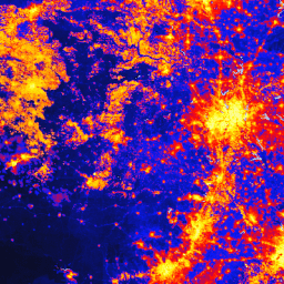
The global Human Modification dataset (gHM) provides a cumulative measure of human modification of terrestrial lands globally at 1 square-kilometer resolution. The gHM values range from 0.0-1.0 and are calculated by estimating the proportion of a given location (pixel) that is modified, the estimated intensity … csp fragmentation human-modification landcover landscape-gradient population -
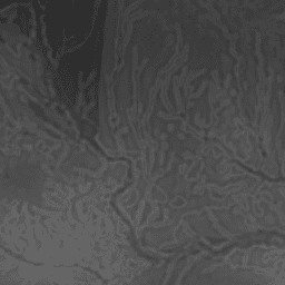
Global ALOS CHILI (Continuous Heat-Insolation Load Index)

CHILI is a surrogate for effects of insolation and topographic shading on evapotranspiration represented by calculating insolation at early afternoon, sun altitude equivalent to equinox. It is based on the 30m "AVE" band of JAXA's ALOS DEM (available in EE as JAXA/ALOS/AW3D30_V1_1). The Conservation Science … aspect csp elevation elevation-topography ergo geophysical -
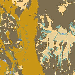
Global ALOS Landforms
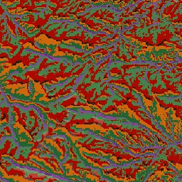
The ALOS Landform dataset provides landform classes created by combining the Continuous Heat-Insolation Load Index (ALOS CHILI) and the multi-scale Topographic Position Index (ALOS mTPI) datasets. It is based on the 30m "AVE" band of JAXA's ALOS DEM (available in EE as JAXA/ALOS/AW3D30_V1_1). The Conservation … aspect csp elevation elevation-topography ergo geophysical -
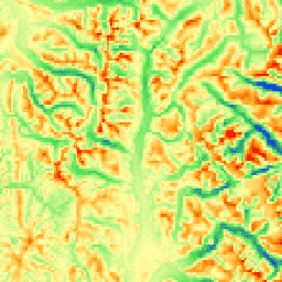
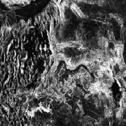
Global ALOS Topographic Diversity

Topographic diversity (D) is a surrogate variable that represents the variety of temperature and moisture conditions available to species as local habitats. It expresses the logic that a higher variety of topo-climate niches should support higher diversity (especially plant) and support species persistence given climatic … aspect csp elevation elevation-topography ergo geophysical -
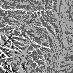
Global ALOS mTPI (Multi-Scale Topographic Position Index)

The mTPI distinguishes ridge from valley forms. It is calculated using elevation data for each location subtracted by the mean elevation within a neighborhood. mTPI uses moving windows of radius (km): 115.8, 89.9, 35.5, 13.1, 5.6, 2.8, and 1.2. It is based on the 30m … aspect csp elevation elevation-topography ergo geophysical -
Global SRTM CHILI (Continuous Heat-Insolation Load Index)
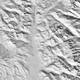
CHILI is a surrogate for effects of insolation and topographic shading on evapotranspiration represented by calculating insolation at early afternoon, sun altitude equivalent to equinox. It is based on the 30m SRTM DEM (available in EE as USGS/SRTMGL1_003). The Conservation Science Partners (CSP) Ecologically Relevant … aspect csp elevation elevation-topography ergo geophysical -
Global SRTM Landforms

The SRTM Landform dataset provides landform classes created by combining the Continuous Heat-Insolation Load Index (SRTM CHILI) and the multi-scale Topographic Position Index (SRTM mTPI) datasets. It is based on the 30m SRTM DEM (available in EE as USGS/SRTMGL1_003). The Conservation Science Partners (CSP) Ecologically … aspect csp elevation elevation-topography ergo geophysical -
Global SRTM Topographic Diversity

Topographic diversity (D) is a surrogate variable that represents the variety of temperature and moisture conditions available to species as local habitats. It expresses the logic that a higher variety of topo-climate niches should support higher diversity (especially plant) and support species persistence given climatic … aspect csp elevation elevation-topography ergo geophysical -
Global SRTM mTPI (Multi-Scale Topographic Position Index)
The mTPI distinguishes ridge from valley forms. It is calculated using elevation data for each location subtracted by the mean elevation within a neighborhood. mTPI uses moving windows of radius (km): 115.8, 89.9, 35.5, 13.1, 5.6, 2.8, and 1.2. It is based on the 30m … aspect csp elevation elevation-topography ergo geophysical -
US Lithology
The Lithology dataset provides classes of the general types of parent material of soil on the surface. It is not derived from any DEM. The Conservation Science Partners (CSP) Ecologically Relevant Geomorphology (ERGo) Datasets, Landforms and Physiography contain detailed, multi-scale data on landforms and physiographic … aspect csp elevation elevation-topography ergo geophysical -
US NED CHILI (Continuous Heat-Insolation Load Index)

CHILI is a surrogate for effects of insolation and topographic shading on evapotranspiration represented by calculating insolation at early afternoon, sun altitude equivalent to equinox. It is based on the USGS's 10m NED DEM (available in EE as USGS/NED). The Conservation Science Partners (CSP) Ecologically … aspect csp elevation elevation-topography ergo geophysical -
US NED Landforms

The ALOS Landform dataset provides landform classes created by combining the Continuous Heat-Insolation Load Index (CHILI) and the multi-scale Topographic Position Index (mTPI) datasets. It is based on the USGS's 10m NED DEM (available in EE as USGS/NED). The Conservation Science Partners (CSP) Ecologically Relevant … aspect csp elevation elevation-topography ergo geophysical -
US NED Physiographic Diversity
The Physiographic Diversity dataset provides an index of the diversity of physiographic types. It was calculated using the Shannon diversity index at multiple scales (km): 115.8, 89.9, 35.5, 13.1, 5.6, 2.8, and 1.2. It is based on the USGS's 10m NED DEM (available in EE … aspect csp elevation elevation-topography ergo geophysical -
US NED Topographic Diversity
Topographic diversity (D) is a surrogate variable that represents the variety of temperature and moisture conditions available to species as local habitats. It expresses the logic that a higher variety of topo-climate niches should support higher diversity (especially plant) and support species persistence given climatic … aspect csp elevation elevation-topography ergo geophysical -
US NED mTPI (Multi-Scale Topographic Position Index)

The mTPI distinguishes ridge from valley forms. It is calculated using elevation data for each location subtracted by the mean elevation within a neighborhood. mTPI uses moving windows of radius (km): 115.8, 89.9, 35.5, 13.1, 5.6, 2.8, and 1.2. It is based on the USGS's … aspect csp elevation elevation-topography ergo geophysical -
US Physiography
The Physiography dataset represents the spatial intersection of landforms (available in EE as ERGo/1_0/US/landforms) and lithology (available in EE as ERGo/1_0/US/lithology) data layers. It provides 247 unique combinations out of a possible 270. The values for each type are formed by concatenating the landform and … aspect csp elevation elevation-topography ergo geophysical