-
Landsat Image Mosaic of Antarctica(LIMA)- 処理済み Landsat シーン(16 ビット)
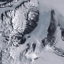
南極のランドサット画像モザイク(LIMA)は、処理されたランドサット 7 ETM+ シーンから作成された、シームレスで実質的に雲のないモザイクです。処理済みの Landsat シーン(16 ビット)は、16 ビットに変換され、太陽角補正で処理され、反射率値に変換されたレベル 1Gt NLAPS シーンです(Bindschadler … antarctica ice landsat-derived lima mosaic satellite-imagery -
Landsat Image Mosaic of Antarctica(LIMA)- 処理済み Landsat シーン(16 ビット)のメタデータ
南極のランドサット画像モザイク(LIMA)は、処理されたランドサット 7 ETM+ シーンから作成された、シームレスで実質的に雲のないモザイクです。処理済みの Landsat シーン(16 ビット)は、16 ビットに変換され、太陽角補正で処理され、反射率値に変換されたレベル 1Gt NLAPS シーンです(Bindschadler … antarctica ice landsat-derived lima mosaic satellite-imagery -
Landsat Image Mosaic of Antarctica(LIMA)16 ビット パンシャープ モザイク

南極のランドサット画像モザイク(LIMA)は、処理されたランドサット 7 ETM+ シーンから作成された、シームレスで実質的に雲のないモザイクです。この LIMA データセットは 16 ビットの中間 LIMA です。モザイクは、パンシャープ処理された正規化された地表反射率シーン(Landsat ETM+ バンド 1、2、3、… antarctica ice landsat-derived lima mosaic satellite-imagery
Datasets tagged lima in Earth Engine
[null,null,[],[],[]]