-
OpenLandMap 長期地表温度月間昼夜差
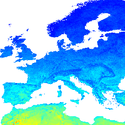
2000 ~ 2017 年の時系列に基づく、1 km での長期的な MODIS LST 昼間と夜間の差異。R の data.table パッケージと分位関数を使用して導出されました。MODIS LST プロダクトの詳細については、こちらのページをご覧ください。南極は対象外です。以下にアクセスして可視化できます。 climate day envirometrix lst mod11a2 modis -
VNP21A1N.002: 夜間地表面温度と日射吸収率(1 日 1 km)
NASA Suomi National Polar-Orbiting Partnership(Suomi NPP)の Visible Infrared Imaging Radiometer Suite(VIIRS)地表面温度と放射率(LST&E)夜間バージョン 1 プロダクト(VNP21A1N)は、夜間のレベル 2 グリッド化(L2G)中間プロダクトから毎日コンパイルされます。L2G プロセスは、1 日あたりの VNP21 スワス グラニュールをマッピングします。 気候 1 日間 陸地 NASA 夜間 NOAA
Datasets tagged night in Earth Engine
[null,null,[],[[["\u003cp\u003eThe NASA VIIRS Land Surface Temperature and Emissivity Night product (VNP21A1N) provides daily nighttime land surface temperature and emissivity data derived from Suomi NPP satellite observations.\u003c/p\u003e\n"],["\u003cp\u003eThe OpenLandMap Long-term Land Surface Temperature dataset offers monthly differences between day and nighttime land surface temperatures based on MODIS data from 2000-2017.\u003c/p\u003e\n"]]],[],null,["# Datasets tagged night in Earth Engine\n\n-\n\n |--------------------------------------------------------------------------------------------------------------------------------------------------------------------------------------------------------------------------------------------------------------------------------------|\n | [### OpenLandMap Long-term Land Surface Temperature Monthly Day-Night Difference](/earth-engine/datasets/catalog/OpenLandMap_CLM_CLM_LST_MOD11A2-DAYNIGHT_M_v01) |\n | Long-term MODIS LST day-time and night-time differences at 1 km based on the 2000-2017 time series Derived using the data.table package and quantile function in R. For more info about the MODIS LST product see this page. Antarctica is not included. To access and visualize ... |\n | [climate](/earth-engine/datasets/tags/climate) [day](/earth-engine/datasets/tags/day) [envirometrix](/earth-engine/datasets/tags/envirometrix) [lst](/earth-engine/datasets/tags/lst) [mod11a2](/earth-engine/datasets/tags/mod11a2) [modis](/earth-engine/datasets/tags/modis) |\n\n-\n\n |--------------------------------------------------------------------------------------------------------------------------------------------------------------------------------------------------------------------------------------------------------------------------------------------------------------------------------------------|\n | [### VNP21A1N.002: Night Land Surface Temperature and Emissivity Daily 1km](/earth-engine/datasets/catalog/NASA_VIIRS_002_VNP21A1N) |\n | The NASA Suomi National Polar-Orbiting Partnership (Suomi NPP) Visible Infrared Imaging Radiometer Suite (VIIRS) Land Surface Temperature and Emissivity (LST\\&E) Night Version 1 product (VNP21A1N) is compiled daily from nighttime Level 2 Gridded (L2G) intermediate products. The L2G process maps the daily VNP21 swath granules ... |\n | [climate](/earth-engine/datasets/tags/climate) [daily](/earth-engine/datasets/tags/daily) [land](/earth-engine/datasets/tags/land) [nasa](/earth-engine/datasets/tags/nasa) [night](/earth-engine/datasets/tags/night) [noaa](/earth-engine/datasets/tags/noaa) |"]]