-
Google ストリートビューの大気質: カリフォルニア州の高解像度大気汚染マッピング
この大規模なベクター データセットには、2015 年 6 月から 2019 年 6 月までのカリフォルニア州における NO、NO2、O3、CH4、CO2、BC、PN2.5、UFP の濃度に関する高解像度大気汚染マッピングが含まれています。このデータセットは、Aclima … air-quality atmosphere nitrogen-dioxide pollution table -
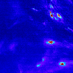
Sentinel-5P NRTI NO2: 準リアルタイムの二酸化窒素
NRTI/L3_NO2 このデータセットは、NO2 濃度の高解像度画像をほぼリアルタイムで提供します。窒素酸化物(NO2 と NO)は、地球の大気中に存在する重要な微量ガスで、対流圏と成層圏の両方に存在します。これらのガスは、人間活動(特に化石燃料の燃焼)の結果として大気中に放出されます。 air-quality atmosphere copernicus esa eu knmi -
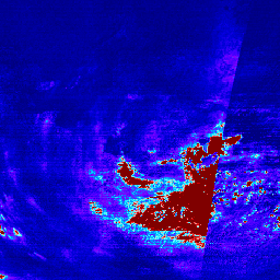
Sentinel-5P OFFL NO2: オフラインの二酸化窒素
OFFL/L3_NO2 このデータセットは、NO2 濃度の高解像度のオフライン画像を提供します。窒素酸化物(NO2 と NO)は、地球の大気中に存在する重要な微量ガスで、対流圏と成層圏の両方に存在します。これらの物質は、人間活動(特に化石燃料の燃焼)の結果として大気中に放出されます。 air-quality atmosphere copernicus esa eu knmi -
TEMPO グリッド化 NO2(QA フィルタ済み)成層圏と対流圏の列 V03
二酸化窒素レベル 3 ファイルは、標準の TEMPO 観測の TEMPO 対象領域をカバーする正規グリッド上の微量ガス情報を提供します。レベル 3 ファイルは、TEMPO の東西スキャン サイクルを構成するすべてのレベル 2 ファイルの情報が結合されて生成されます。ラスターには次のものがあります。 air-quality nasa nitrogen-dioxide pollution satellite-imagery tropomi -
TEMPO グリッド状の NO2 成層圏と対流圏の列 V03
二酸化窒素レベル 3 ファイルは、標準の TEMPO 観測の TEMPO 対象領域をカバーする正規グリッド上の微量ガス情報を提供します。レベル 3 ファイルは、TEMPO の東西スキャン サイクルを構成するすべてのレベル 2 ファイルの情報が結合されて生成されます。ラスターには次のものがあります。 air-quality nasa nitrogen-dioxide pollution satellite-imagery tropomi
Datasets tagged nitrogen-dioxide in Earth Engine
[null,null,[],[[["\u003cp\u003eThis page provides access to datasets related to nitrogen dioxide (NO2) and air quality, including near real-time and offline imagery from Sentinel-5P.\u003c/p\u003e\n"],["\u003cp\u003eThe datasets offer high-resolution insights into NO2 concentrations, an important trace gas influenced by human activities like fossil fuel combustion.\u003c/p\u003e\n"],["\u003cp\u003eGoogle Street View Air Quality data provides detailed air pollution mapping of various pollutants, including NO2, across California from 2015 to 2019.\u003c/p\u003e\n"]]],[],null,["# Datasets tagged nitrogen-dioxide in Earth Engine\n\n-\n\n |--------------------------------------------------------------------------------------------------------------------------------------------------------------------------------------------------------------------------------------------------------------------------------------------------------|\n | [### Google Street View Air Quality: High Resolution Air Pollution Mapping in California](/earth-engine/datasets/catalog/GOOGLE_AirView_California_Unified_2015_2019) |\n | This large vector dataset contains high resolution air pollution mapping of NO, NO2, O3, CH4, CO2, BC, PN2.5, and UFP concentrations in California between June 2015 and June 2019. The dataset consists of measurements collected using four Google Street View vehicles equipped with the Aclima ... |\n | [air-quality](/earth-engine/datasets/tags/air-quality) [atmosphere](/earth-engine/datasets/tags/atmosphere) [nitrogen-dioxide](/earth-engine/datasets/tags/nitrogen-dioxide) [pollution](/earth-engine/datasets/tags/pollution) [table](/earth-engine/datasets/tags/table) |\n\n-\n\n |------------------------------------------------------------------------------------------------------------------------------------------------------------------------------------------------------------------------------------------------------------------------------------------------------------------------------------|\n | [### Sentinel-5P NRTI NO2: Near Real-Time Nitrogen Dioxide](/earth-engine/datasets/catalog/COPERNICUS_S5P_NRTI_L3_NO2) |\n | NRTI/L3_NO2 This dataset provides near real-time high-resolution imagery of NO2 concentrations. Nitrogen oxides (NO2 and NO) are important trace gases in the Earth's atmosphere, present in both the troposphere and the stratosphere. They enter the atmosphere as a result of anthropogenic activities (notably fossil fuel ... |\n | [air-quality](/earth-engine/datasets/tags/air-quality) [atmosphere](/earth-engine/datasets/tags/atmosphere) [copernicus](/earth-engine/datasets/tags/copernicus) [esa](/earth-engine/datasets/tags/esa) [eu](/earth-engine/datasets/tags/eu) [knmi](/earth-engine/datasets/tags/knmi) |\n\n-\n\n |----------------------------------------------------------------------------------------------------------------------------------------------------------------------------------------------------------------------------------------------------------------------------------------------------------------------------------------|\n | [### Sentinel-5P OFFL NO2: Offline Nitrogen Dioxide](/earth-engine/datasets/catalog/COPERNICUS_S5P_OFFL_L3_NO2) |\n | OFFL/L3_NO2 This dataset provides offline high-resolution imagery of NO2 concentrations. Nitrogen oxides (NO2 and NO) are important trace gases in the Earth's atmosphere, present in both the troposphere and the stratosphere. They enter the atmosphere as a result of anthropogenic activities (notably fossil fuel combustion ... |\n | [air-quality](/earth-engine/datasets/tags/air-quality) [atmosphere](/earth-engine/datasets/tags/atmosphere) [copernicus](/earth-engine/datasets/tags/copernicus) [esa](/earth-engine/datasets/tags/esa) [eu](/earth-engine/datasets/tags/eu) [knmi](/earth-engine/datasets/tags/knmi) |\n\n-\n\n |---------------------------------------------------------------------------------------------------------------------------------------------------------------------------------------------------------------------------------------------------------------------------------------------------------------------------------------|\n | [### TEMPO gridded NO2 (QA filtered) tropospheric and stratospheric columns V03](/earth-engine/datasets/catalog/NASA_TEMPO_NO2_L3_QA) |\n | Nitrogen dioxide Level 3 files provide trace gas information on a regular grid covering the TEMPO field of regard for nominal TEMPO observations. Level 3 files are derived by combining information from all Level 2 files constituting a TEMPO East-West scan cycle. The rasters contain ... |\n | [air-quality](/earth-engine/datasets/tags/air-quality) [nasa](/earth-engine/datasets/tags/nasa) [nitrogen-dioxide](/earth-engine/datasets/tags/nitrogen-dioxide) [pollution](/earth-engine/datasets/tags/pollution) [satellite-imagery](/earth-engine/datasets/tags/satellite-imagery) [tropomi](/earth-engine/datasets/tags/tropomi) |\n\n-\n\n |---------------------------------------------------------------------------------------------------------------------------------------------------------------------------------------------------------------------------------------------------------------------------------------------------------------------------------------|\n | [### TEMPO gridded NO2 tropospheric and stratospheric columns V03](/earth-engine/datasets/catalog/NASA_TEMPO_NO2_L3) |\n | Nitrogen dioxide Level 3 files provide trace gas information on a regular grid covering the TEMPO field of regard for nominal TEMPO observations. Level 3 files are derived by combining information from all Level 2 files constituting a TEMPO East-West scan cycle. The rasters contain ... |\n | [air-quality](/earth-engine/datasets/tags/air-quality) [nasa](/earth-engine/datasets/tags/nasa) [nitrogen-dioxide](/earth-engine/datasets/tags/nitrogen-dioxide) [pollution](/earth-engine/datasets/tags/pollution) [satellite-imagery](/earth-engine/datasets/tags/satellite-imagery) [tropomi](/earth-engine/datasets/tags/tropomi) |"]]