
Özelleştirebileceğiniz harita özellikleri bir hiyerarşi içinde düzenlenir ve her harita özelliğinde özelleştirebileceğiniz bir veya daha fazla stil öğesi bulunur. Çoğu üst düzey özelliğin bir veya daha fazla alt harita özelliği vardır. Harita stillerini özelleştirirken kullanabileceğiniz çeşitli seçenekler vardır:
Temel harita stilinden devralma: Bir harita özelliğinin stil öğesini özelleştirmezseniz bu öğe, temel haritadaki varsayılan stili devralır.
Üst öğelerden devralma: Bir üst harita özelliğindeki stil öğesini özelleştirerek altındaki tüm özelleştirilmemiş alt harita özelliklerinin stilleri üst öğelerinden devralmasını sağlayın.
Üst stili geçersiz kılma: Bir alt harita özelliğindeki stil öğesini özelleştirerek bu öğenin üst stilini geçersiz kılabilirsiniz.
Yakınlaştırma seviyelerini özelleştirme: Bazı harita özelliklerinde, farklı yakınlaştırma seviyeleri için stil öğelerini özelleştirebilirsiniz. Ayrıntılı bilgi için Stil yakınlaştırma düzeyleri başlıklı makaleyi inceleyin.
Her harita özelliği için stilini değiştirebileceğiniz öğeler
Harita özelliklerinde, harita özelliğinin türüne bağlı olarak özelleştirebileceğiniz aşağıdaki stil öğelerinden biri veya daha fazlası bulunabilir:
Görünürlük: Bu özelliğin haritada gösterilip gösterilmeyeceği.
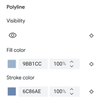
Dolgu rengi: Poligonlar ve çoklu çizgiler için dolgu rengi.
Çizgi rengi: Poligonlar ve çoklu çizgiler için dış çizgi rengi.
Çizgi genişliği: Poligonların ve çoklu çizgilerin ana hatlarının kalınlığı. Sonuçlar, yakınlaştırma seviyesine bağlı olarak değişiklik gösterebilir. Anahat istemiyorsanız Kontur rengini Dolgu rengiyle aynı yapın veya Kontur genişliğini 0 olarak ayarlayın.
Simge rengi: Öİ dışındaki simgelerin dolgu rengi.
Raptiye dış çizgi rengi: Önemli yer raptiyelerinin dış çizgi rengi.
Raptiye dolgu rengi: Önemli yer raptiyelerinin dolgu rengi.
Raptiye glif rengi: Önemli yer raptiyelerinin glif rengi.
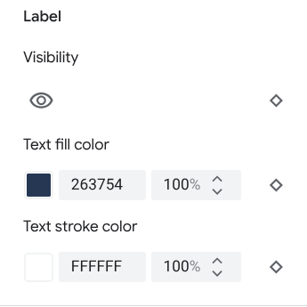
Metin dolgu rengi: Metin etiketlerinin dolgu rengi.
Metin kontur rengi: Metin etiketlerinin ana hat rengi.
Harita özelliğinin görünürlüğü
Harita özelliklerini gizlediğinizde veya şeffaf hale getirdiğinizde sınır hataları ortaya çıkabilir. Harita özelliği sınırları her zaman kesin olmayabilir ancak tüm katmanlar görünür olduğunda doğru görünmesi için ayarlanır. Harita katmanlarının birbirini nasıl etkilediği hakkında daha fazla bilgi edinmek için Çakışan stilleri yönetme başlıklı makaleyi inceleyin.
Harita özelliklerini göstermenin veya gizlemenin iki yolu vardır: görünürlük ve opaklık.
Görünürlük
Haritanızda bir harita özelliğini göstermek veya gizlemek için Görünürlük stil öğesini kullanın. Daha fazla bilgi için Hangi harita özelliklerinin gösterileceğini filtreleme başlıklı makaleyi inceleyin.
Opaklık
Ayrıca, aşağıdaki stil öğelerinin opaklığını ayarlayarak harita özelliğini şeffaf hale getirebilirsiniz: Dolgu rengi, Fırça rengi, Metin dolgu rengi ve Metin fırça rengi.
Bir harita özelliğinin opaklığını ayarladığınızda görünümü, altındaki harita özelliklerine bağlıdır. Beklenmeyen stil değişikliklerini önlemek için tüm çakışan özelliklere özel bir stil ayarlayın.
Poligonlar ve Çoklu Çizgiler
Şekille (ör. plaj, ülke ve şehir meydanı) veya çizgiyle (ör. demiryolu hattı, otoyol ve patika) gösterilen harita özelliği türlerinde genellikle şu öğeleri stilize edebilirsiniz: görünürlük, dolgu rengi, kontur rengi ve kontur genişliği.
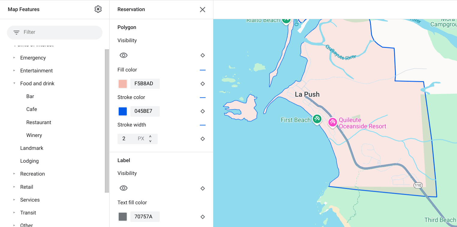
Poligon stilini özelleştirme örneği - Reservation özellik türü için
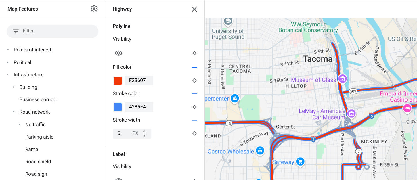
Çoklu çizgi stilini özelleştirme örneği - Otoyol birim türü için
Kontur rengi ve kontur genişliği özelleştirmeleri, aşağıdaki harita özellikleri için kullanılamaz:
Siyasi harita özellikleri: Stilleri, haritadaki anlamı aktarır. Örneğin, bölge türünü belirtir. Siyasi harita özellikleri Ülke, Sınır, Eyalet veya il ve Alt yerleşim birimi'dir.
3D tarzı binalar.
Simgeler ve Metin Etiketleri
Tamamen veya kısmen etiketle gösterilen harita özelliği türleri (ör. ulaşım ve diğer önemli yer dışı türler) için genellikle şu öğeleri stilize edebilirsiniz: görünürlük, simge rengi, metin dolgu rengi ve metin kenarlık rengi.
![]()
Simge stilini belirleme ve etiket metni özelleştirme örneği
Pinler
Önemli yer harita özelliği türlerini aşağıdaki öğelerle stilize edebilirsiniz: Görünürlük, İşaretçi ana hat rengi, İşaretçi dolgu rengi, İşaretçi glif rengi, Metin dolgu rengi ve Metin ana hat rengi.
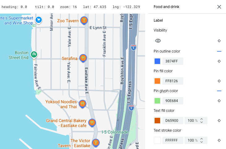
Pin stilini ve etiket metni özelleştirme örneği
Harita özellik hiyerarşisi
Üst düzey harita özellikleriyle ilgili bu tablolarda, her birinin altında hangi alt harita özelliklerinin kullanılabildiği gösterilmektedir.
Önemli yer |
||
|---|---|---|
| Acil durum | İtfaiye Hastane Eczane Polis |
|
| Eğlence | Sanat Casino Sinema Tarihi Müze Eğlence parkı Turistik yer |
|
| Yiyecek ve içecek | Bar Kafe Restoran Şaraphane |
|
| Önemli nokta | ||
| Konaklama | ||
| Eğlence ve dinlenme | Plaj Tekne gezintisi Balıkçılık Golf sahası Kaplıca Doğa koruma alanı Park Zirve Spor kompleksi Spor sahası Patika başlangıcı Hayvanat bahçesi |
|
| Perakende | Market Alışveriş |
|
| Hizmet | ATM Banka Araç kiralama Elektrikli araç şarj istasyonu Benzin istasyonu Otopark Postane Dinlenme tesisi Tuvalet |
|
| Toplu Taşıma | Havalimanı | |
| Diğer | Köprü | |
| Mezarlık | ||
| Resmi Kurumlar | ||
| Kitaplık | ||
| Askeriye | ||
| İbadethane | Budist Hıristiyan Hindu İslam Caynizm Yahudi Şintoizm Sihizm |
|
| Okul | ||
| Kent meydanı | ||
Politik |
|
|---|---|
| Ülke | |
| Kenarlık | |
| Rezervasyon | |
| Eyalet veya il | |
| Şehir | |
| Semt | |
| Mahalle | |
| Arazi parseli | |
Altyapı |
|||
|---|---|---|---|
| * Yol ayrıntısı harita özellikleri yalnızca yol seviyesinde ayrıntıların etkinleştirildiği Google Haritalar Platformu ürünlerinde kullanılabilir. Daha fazla bilgi için Google Haritalar Platformu'nda yol düzeyinde ayrıntılar başlıklı makaleyi inceleyin. | |||
| Köprü | Ticari Kapalı |
||
| İş koridoru | |||
| Yol ağı | Trafik yok | Araçsız alışveriş caddesi | |
| Patika | Asfalt Asfaltsız |
||
| Park yeri | |||
| Rampa | |||
| Yol siperliği | |||
| Yol işareti | |||
| Yol | Ana yol Otoyol Yerel Çıkış yok |
||
| Yol ayrıntısı* | Yüzey Yaya geçidi Kaldırım Kavşak Yön oku |
||
| Demiryolu hattı | Ticari Gündelik |
||
| Toplu taşıma durağı | Bisiklet paylaşımı | ||
| Otobüs durağı | |||
| Feribot iskelesi | |||
| Füniküler istasyonu | |||
| Teleferik istasyonu | |||
| Monoray | |||
| Tren istasyonu | Metro istasyonu Tramvay istasyonu |
||
| Kentsel alan | |||
Doğal |
||
|---|---|---|
| † Arazi örtüsü haritası özellikleri, uydu görüntüsü renklerine dayalı yaklaşık değerlerdir ve gerçek dünya koşullarını doğru şekilde yansıtmayabilir. | ||
| Kıta | ||
| Archipelago | ||
| Ada | ||
| Arsa | Arazi örtüsü† | Ekinler Kuru tarım Orman Buz Kum Çalı Tundra |
| Su | Okyanus Göl Nehir Diğer |
|
| Temel | ||