
এই নথিতে আপনার ম্যাপ স্টাইল সেট আপ করার সময় ঘটতে পারে এমন সাধারণ সমস্যা এবং সেগুলি সমাধানের উপায় বর্ণনা করা হয়েছে।
বাগ অথবা ফিচার রিকোয়েস্ট ফাইল করতে ক্লিক করুন।
পরিচিত সমস্যা
ক্লাউড-ভিত্তিক ম্যাপের স্টাইলিং সংক্রান্ত সর্বশেষ জ্ঞাত সমস্যাগুলো দেখতে, রিলিজ নোট দেখুন।
বার্তা
এখানে কিছু বার্তা এবং সেগুলোর সমাধান দেওয়া হলো যা আপনি দেখতে পারেন:
mapId উপস্থিত থাকলে ম্যাপের styles প্রপার্টি সেট করা যায় না।প্রিভিউ ম্যাপটি একটি ভেক্টর ম্যাপ ব্যবহার করে। যখন আপনার ওয়েব ব্রাউজারে ভেক্টর ম্যাপ লোড করা যায় না, তখন এটি একটি "নো ম্যাপ" অভিজ্ঞতায় ফিরে যায়:
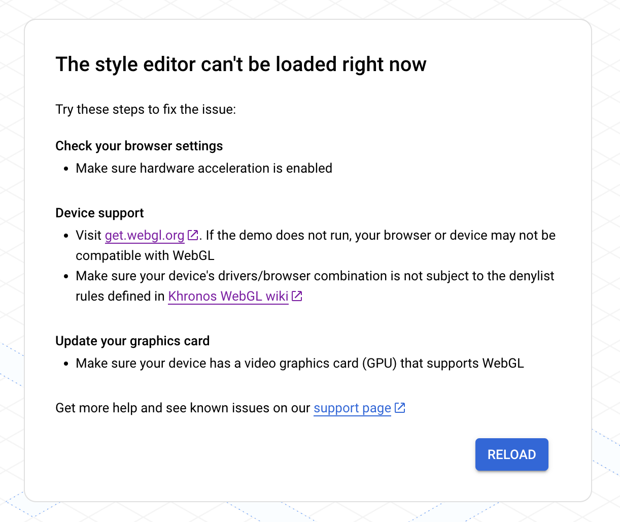
আপনি যদি এই সমস্যার সম্মুখীন হন, তাহলে নিম্নলিখিতগুলি চেষ্টা করুন:
- আপনার ব্রাউজার সেটিংস পরীক্ষা করে নিশ্চিত করুন যে হার্ডওয়্যার অ্যাক্সিলারেশন চালু আছে।
- আপনার ডিভাইসটি সমর্থিত কিনা তা জানতে get.webgl.org দেখুন। যদি ডেমোটি না চলে, তাহলে আপনার ব্রাউজার বা ডিভাইসটি WebGL-এর সাথে সামঞ্জস্যপূর্ণ নাও হতে পারে। নিশ্চিত করুন যে আপনার ডিভাইসের ড্রাইভার/ব্রাউজার সংমিশ্রণটি Khronos WebGL উইকিতে সংজ্ঞায়িত ডিনাইলিস্ট নিয়মের আওতাভুক্ত নয়।
- আপনার গ্রাফিক্স কার্ড আপডেট করুন এবং নিশ্চিত করুন যে আপনার ডিভাইসে WebGL সমর্থনকারী একটি ভিডিও গ্রাফিক্স কার্ড (GPU) রয়েছে। অ্যাপ্লিকেশন এবং ওয়েবসাইটের প্রয়োজনীয়তা দেখুন।
অতিরিক্ত সহায়তার জন্য, GMP WebGL সাপোর্ট দেখুন।
শৈলী সংক্রান্ত সমস্যা
একটি স্টাইল তৈরি বা আপডেট করার পরে আপনি নিম্নলিখিত বার্তাগুলি প্রদর্শিত হতে দেখতে পারেন।
আমার স্টাইলের পরিবর্তনগুলো অ্যাপ বা ওয়েবসাইটে আপডেট হচ্ছে না।
আপনার অ্যাপ এবং ওয়েবসাইটগুলিতে স্টাইলের পরিবর্তনগুলি কার্যকর হতে কয়েক ঘন্টা সময় লাগতে পারে, এবং ডিভাইসগুলি ইন্টারনেটের সাথে সংযুক্ত না থাকলে অ্যাপগুলিতে আরও বেশি সময় লাগতে পারে। কয়েক ঘন্টা পরেও যদি আপনি আপনার স্টাইলের পরিবর্তনগুলি দেখতে না পান, তাহলে নিম্নলিখিত বিষয়গুলি পরীক্ষা করুন:
আপনার স্টাইল আপডেটটি প্রকাশ করেছেন কিনা তা নিশ্চিত করুন।
আপনি যদি কোনো ডুপ্লিকেট স্টাইলে পরিবর্তন করে থাকেন, তাহলে নিশ্চিত করুন যে আপনি আপনার ম্যাপ আইডিটি সেই ডুপ্লিকেট স্টাইলের সাথে যুক্ত করেছেন। বিস্তারিত জানতে, আপনার স্টাইলে ম্যাপ আইডি যুক্ত করা বা অপসারণ করা দেখুন।
আমি প্রিভিউ ম্যাপে আমার স্টাইলের পরিবর্তনগুলো দেখতে পাচ্ছি না।
যদি আপনি কোনো পরিবর্তন করেন এবং প্রিভিউ ম্যাপে সেই পরিবর্তনটি দেখতে না পান, তাহলে এখানে কিছু উপায় দেওয়া হলো যা আপনি চেষ্টা করে দেখতে পারেন।
স্টাইলের ওভারল্যাপ পরীক্ষা করুন : বিস্তারিত জানতে, ওভারল্যাপ হওয়া স্টাইলগুলো পরিচালনা দেখুন।
স্টাইল ইনহেরিটেন্স ওভাররাইড পরীক্ষা করুন : আপনি যে স্টাইলটি সেট করছেন তার নিচে কোনো কাস্টম চাইল্ড স্টাইল আছে কিনা তা পরীক্ষা করে দেখুন, যা তার প্যারেন্ট স্টাইলকে ওভাররাইড করছে। স্টাইল ইনহেরিটেন্স সম্পর্কে বিস্তারিত জানতে, ‘আন্ডারস্ট্যান্ড ম্যাপ স্টাইল ইনহেরিটেন্স অ্যান্ড হায়ারার্কি’ দেখুন।
ম্যাপের জুম লেভেল পরিবর্তন করুন : এমন হতে পারে যে, আপনি যে ম্যাপ ফিচারগুলো স্টাইল করছেন, সেগুলো বর্তমান জুম লেভেলে ম্যাপে দৃশ্যমান হচ্ছে না।
জুম ইন করুন : আপনি যদি নিশ্চিত হন যে বৈশিষ্ট্যটি মানচিত্রে উপস্থিত আছে, তবে আরও বিস্তারিত দেখার জন্য জুম ইন করুন এবং এটি দেখা যেতে পারে।
জুম আউট করুন : কিছু বড় ম্যাপ ফিচারের ক্ষেত্রে, আপনার স্টাইলিং প্রদর্শিত হওয়ার আগে বিস্তারিত ফিচারগুলো অদৃশ্য না হওয়া পর্যন্ত আপনাকে জুম আউট করতে হতে পারে।
আমার লেখাটি ঝাপসা বা অস্পষ্ট দেখাচ্ছে।
টেক্সটের ফিল এবং স্ট্রোকের জন্য আপনার বেছে নেওয়া রঙগুলোর মধ্যে যথেষ্ট বৈসাদৃশ্য না থাকলে, ফন্টটি মোটা এবং ঝাপসা দেখায়, কারণ স্ট্রোক (আউটলাইন) এবং ফিল একসাথে মিশে যায়। এমন রঙ নির্বাচন করুন যেগুলোর মধ্যে যথেষ্ট বৈসাদৃশ্য রয়েছে।
আমার স্টাইলটা নিষ্প্রভ লাগছে অথবা রঙটা ভুল।
আপনি যে ম্যাপ ফিচারটি স্টাইল করছেন তা এক বা একাধিক অন্য ম্যাপ ফিচারের সাথে ওভারল্যাপ করতে পারে। সাহায্যের জন্য, ওভারল্যাপ হওয়া স্টাইলগুলো পরিচালনা দেখুন।
ভুল ম্যাপ ফিচারগুলোকে স্টাইল করা হচ্ছে
আপনি যদি আপনার সেট করা স্টাইলের সাথে মেলে এমন ম্যাপ ফিচার দেখতে পান, তাহলে হতে পারে যে সেই ফিচারগুলোর ডিফল্ট ম্যাপ স্টাইলটি আপনার সেট করা স্টাইলের মতোই। এখানে কিছু উপায় দেওয়া হলো যা আপনি চেষ্টা করে দেখতে পারেন:
যে ম্যাপ ফিচারটি মিলে যায়, সেটির ভিজিবিলিটি বন্ধ করে দিন । উদাহরণস্বরূপ, আপনি যদি ওয়াইনারিকে গাঢ় লাল রঙে সেট করতে চান এবং লক্ষ্য করেন যে ইমার্জেন্সি POI-গুলো লাল রঙের, যা আপনার ব্যবহারকারীদের জন্য বিভ্রান্তিকর হতে পারে। এই বিভ্রান্তি এড়াতে আপনি ইমার্জেন্সি POI-গুলোর ভিজিবিলিটি বন্ধ করে দিতে পারেন।
মানচিত্রের যে বৈশিষ্ট্যগুলো আপনি মেলাতে চান না, সেগুলোর স্টাইল পরিবর্তন করুন । উপরের উদাহরণে, বিভ্রান্তি এড়াতে আপনি জরুরি POI-গুলোর স্টাইল কমলা রঙে পরিবর্তন করতে পারেন।
আমার ম্যাপ স্টাইল লোড করার চেষ্টা করার সময় একটি ত্রুটি দেখাচ্ছে।
আপনি একই সাথে ম্যাপ আইডি এবং স্টাইল ব্যবহার করতে পারবেন না। আপনি নিম্নলিখিতগুলির মধ্যে একটি করতে পারেন:
সুপারিশকৃত : ম্যাপ স্টাইলটি সরিয়ে দিন এবং ক্লাউড কনসোল ব্যবহার করে ম্যাপ আইডির সাথে যুক্ত স্টাইলটি সম্পাদনা করুন। এই পদ্ধতিতে, আপনি এমন একটি স্টাইল তৈরি করতে পারবেন যা সমস্ত প্ল্যাটফর্মে প্রযোজ্য হবে। বিস্তারিত জানতে, ‘একটি ম্যাপ আইডির সাথে একটি স্টাইল যুক্ত করুন’ দেখুন।
ম্যাপ আইডিটি সরিয়ে দিন এবং 'Add a styled map' ব্যবহার করে প্রতিটি অ্যাপ প্ল্যাটফর্মের জন্য স্টাইলটি সম্পাদনা করুন। যেহেতু JSON স্টাইলিং প্ল্যাটফর্ম-নির্দিষ্ট, তাই আপনি যে প্রতিটি অ্যাপ প্ল্যাটফর্মে স্টাইল করা ম্যাপগুলো প্রদর্শন করবেন, তার জন্য আপনাকে স্টাইল তৈরি করতে হবে।
আপনার কাছে যদি আগে থেকেই কোনো JSON ম্যাপ স্টাইল থাকে যা আপনি ক্লাউড-ভিত্তিক ম্যাপের স্টাইলিংয়ের জন্য ব্যবহার করতে চান, তাহলে আপনি সেটি ইম্পোর্ট করতে পারেন। বিস্তারিত জানতে, “একটি JSON ম্যাপ স্টাইল ইম্পোর্ট করুন” দেখুন।